Maps of Saratov

Nova Et Accurata Wolgae Fluminis, olim RHA dicti Delineatio [Karte, Teil 1], in: Novus atlas absolutissimus, Bd. 1, S. 87.
1 Karte aus Atlas Janssonius Offizin
NOVA & ACCVRATA | WOLGÆ FLVMINIS
olim RHA dicti, | DELINEATIO | Auctore | ADAMO OLEARIO. [Amsterdam : Joan Blaeu]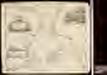
Nova et accurata Wolgæ fluminis olim Rha dicti delineatio / auctore Adamo Oleario
1 : 1300000 1 Karte in 3 Teilen : Kupferdruck ; 48 x 57 cm Olearius, Adam [Verlag nicht ermittelbar]
Nova et accurata Wolgæ fluminis olim Rha dicti delineatio / auctore Adamo Oleario
1 : 1400000 1 Karte in 2 Teilen : Kupferdruck ; 47 x 55 cm Janssonius van Waesbergen, Johannes Janssonius-Waesbergius et Moses Pitt
Otčetnaja karta pochoda Īoanna Groznago pod Kazan' v 1552 g.
Russland Khanat Kasan Kasan Krieg Iwan IV.
Obščaja geologičeskaja karta evropejskoj Rossii : List 92: Saratov - Penza
1 : 420000 sostavili I. Sintsov i S. Nikitin = Carte géologique générale de la Russie d'Europe : Feuille 92: Saratov - Pensa dressée par I. Sintzov et S. Nikitin [S.l.] : [s.n.]
Mittlerer Theil des Saratowschen Gouvernements mit den deutschen Colonieen
Russland, Saratow (Gouvernement), Wolgadeutsche
Berg- und Wiesenufer von Saratow
1 : 2000000 Saratow
Izměnenīja za stolětīe v tečenīi rěki Sury pod Penzoj : Konec XVIII věka
Russland Pensa Umland Flusslaufverlegung
Izměnenīja za stolětīe v tečenīi rěki Sury pod Penzoj : Konec XIX věka
Russland Pensa Umland Flusslaufverlegung
General'nyj plan Nižegorodskoj Makar'jevskoj Jarmorki s pokazanijem na onom gostin[n]ago dvora i vsěch vremjannych poměščenij
1 : 4000 Nižnij Novgorod (Rusko) Milanov, N. izdannyj kandidatom kommercii N. Milanovym
Plansc jarmaročnago gostinago dvora, 1833
Moskva : Lozunova
[Nižnjaja Volga]
Volha-oblast (Rusko)
Feuille 20 (F III), uit: Carte géologique internationale de l'Europe : la carte, votée au congrès géologique international de Bologne en 1881, est exécutée conformément aux décisions d'une commission internationale, avec le concours des gouvernements, sous le dir. de M.M. Beyrich et Hauchecorne
Annotatie: Blad 48 gamme des couleurs; blad 49: bladwijzer en titelblad Heinrich Ernst Beyrich 1815-1896; Wi. Hauchecorne Berlin : Reimer / (Berlin: Institut lithographique)
Ostrussland
1 : 2000000 Rusko Kartographische Anstalt Freytag-Berndt u. Artaria
Russia in Europe Part VII.
1 : 4300000 Society for the Diffusion of Useful Knowledge (Great Britain)
[Ost-Europa, Blatt 4]
Adolf Stieler's Handatlas über alle Theile der Erde und über das Weltgebäude Stieler, Adolf Justus Perthes
Partie meridionale de Moscovie / dressée par G. de L'Isle
1 : 3200000 1 Karte : Kupferdruck ; 40 x 55 cm L'Isle, Guillaume de chez Ian Barend Elwe
Le cours de la riviere de Wolga, anciennement appellée Rha selon la relation d'Olearius / a Leide p
1 : 2500000 1 Karte : Kupferdruck ; 23 x 58 cm Olearius, Adam chez J. Covens et C. Mortier
Governi di Moscovia e Woronez colle loro provincie nella Russia europea
1 Karte : Kupferdruck ; 41 x 32 cm Zatta; Zuliani; Pitteri presso Antonio Zatta
Governi di Moscovia e Woronez colle loro provincie nella Russia europea / G. Zuliani inc. ; G. Pitte
1 : 3500000 1 Karte : Kupferdruck ; 41 x 32 cm Zuliani, Giuliano presso Antonio Zatta
I governi di Moscovia e Woronez nell'impero della Russia in Europa / Gio. Ma. Cassini som.co. inc.
1 : 3500000 1 Karte : Kupferdruck ; 44 x 31 cm Cassini, Giovanni Maria Presso la Calcografia Camerale
U.S.S.R. in Europe - Central. Pergamon World Atlas.
1 : 2500000 Polish Army Topography Service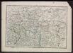
Voenno-dorožnaja karta časti Rossii i pograničnych zemelʹ
1 : 1680000 Zentralrussland, Moskau Šubert [Generalmajor]
Schema historických momentů československ. vojenských operací na Sibiři 1918-1919

Zasěčnyja čerty.
Russland Krieg
Karta srednerusskoj černozemnoj oblasti
Russland Zentralrussland Topografie
Feuille 27 (F IV), uit: Carte géologique internationale de l'Europe : la carte, votée au congrès géologique international de Bologne en 1881, est exécutée conformément aux décisions d'une commission internationale, avec le concours des gouvernements, sous le dir. de M.M. Beyrich et Hauchecorne
Annotatie: Blad 48 gamme des couleurs; blad 49: bladwijzer en titelblad Heinrich Ernst Beyrich 1815-1896; Wi. Hauchecorne Berlin : Reimer / (Berlin: Institut lithographique)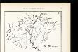
Srednerusskaja černozemnaja oblast' v IX-XIII v.v: IX-XI věka
Russland Zentralrussland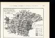
![Nova Et Accurata Wolgae Fluminis, olim RHA dicti Delineatio [Karte, Teil 1], in: Novus atlas absolutissimus, Bd. 1, S. 87.](https://images-2.georeferencer.com/images/iiif/775864236640/full/,300/0/native.jpg)

