Maps of Orenburg

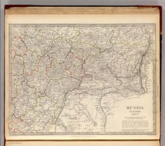
Russia in Europe Part VII.
1 : 4300000 Society for the Diffusion of Useful Knowledge (Great Britain)
Russia 7.
1 : 5068800 Letts, Son & Co.
Friedensdislokation im europäischen Russland
1 : 2800000 Rusko západní
Moscovie Meridionale.
1 : 2600000 L'Isle, Guillaume de, 1675-1726
Geologičeskaja karta Evropejskoj Rossii
1 : 2500000 Ostblatt Karpinskij, A.P. (Aleksandr Petrovič) Kartografičeskoe zavedenie A.Il'ina
Ost-Europa, No. 4: Central-Russland.
1 : 3700000 Petermann, A.
[Ost-Europa in 6 Blättern, Blatt 4]
Handatlas über alle Theile der Erde und über das Weltgebäude Stieler, Adolf Justus Perthes
[Ost-Europa in 6 Blättern, Enthaltend: Norwegen, Schweden, Russland, Kaukasien und die Türkei, Blatt 4]
Hand-Atlas über alle Theile der Erde und über das Weltgebäude Stieler, Adolf Justus Perthes
La Moscovie meridionale, suivant les nouvelles observations de Messrs. de L'Académie Royale de Scie
1 : 5800000 1 Karte : Kupferdruck ; 21 x 29 cm chez Pierre van der AA
La Moscovie meridionale, suivant les nouvelles observations de Messrs. de L'Académie Royale de Scie
1 : 5800000 1 Karte : Kupferdruck ; 21 x 29 cm chez Pierre van der AA
La Moscovie meridionale, suivant les nouvelles observations de Messrs. de L'Académie Royale de Scie
1 : 5800000 1 Karte : Kupferdruck ; 21 x 29 cm chez Covens et Mortier
La Moscovie meridionale, suivant les nouvelles observations de Messrs. de L'Académie Royale de Scie
1 : 5800000 1 Karte : Kupferdruck ; 21 x 29 cm chez Covens et Mortier
Ostrussland
1 : 2000000 Rusko Kartographische Anstalt Freytag-Berndt u. Artaria
[Ost-Europa, Blatt 4]
Adolf Stieler's Handatlas über alle Theile der Erde und über das Weltgebäude Stieler, Adolf Justus Perthes
Partie meridionale de Moscovie / dressée par G. de L'Isle
1 : 3200000 1 Karte : Kupferdruck ; 40 x 55 cm L'Isle, Guillaume de chez Ian Barend Elwe
[X], uit: Geognostische Karte des Oesterreichischen Kaiserstaates mit einem grossen Theile Deutschland's u. Italien / hauptsachlich nach ... Haidinger's geognostischer Karte dieses Staates bearb. von Josef Scheda
1 : 3000000 titelvariant: General-Karte von Europa in 25 Blättern; Annotatie: Bijlage bij: General-Karte von Europa in 25 Blättern. - 1:2.592.000. - 1845-1847 Scheda, Joseph Wien : K.K. Militär. Geografisch. Institut
Governi di Moscovia e Woronez colle loro provincie nella Russia europea
1 Karte : Kupferdruck ; 41 x 32 cm Zatta; Zuliani; Pitteri presso Antonio Zatta
Governi di Moscovia e Woronez colle loro provincie nella Russia europea / G. Zuliani inc. ; G. Pitte
1 : 3500000 1 Karte : Kupferdruck ; 41 x 32 cm Zuliani, Giuliano presso Antonio Zatta
I governi di Moscovia e Woronez nell'impero della Russia in Europa / Gio. Ma. Cassini som.co. inc.
1 : 3500000 1 Karte : Kupferdruck ; 44 x 31 cm Cassini, Giovanni Maria Presso la Calcografia Camerale
Nouvelle carte géographique du grand royaume de Moscovie représentant la partie méridionale &c. /
1 : 2600000 1 Karte : Kupferdruck ; 48 x 69 cm Visscher, Nicolas [Verlag nicht ermittelbar]
[Nižnjaja Volga]
Volha-oblast (Rusko)
Feuille 20 (F III), uit: Carte géologique internationale de l'Europe : la carte, votée au congrès géologique international de Bologne en 1881, est exécutée conformément aux décisions d'une commission internationale, avec le concours des gouvernements, sous le dir. de M.M. Beyrich et Hauchecorne
Annotatie: Blad 48 gamme des couleurs; blad 49: bladwijzer en titelblad Heinrich Ernst Beyrich 1815-1896; Wi. Hauchecorne Berlin : Reimer / (Berlin: Institut lithographique)
Imperii Moscovitici
1 : 2900000 Bělorusko Delisle, Guillaume Ioh. Michael Probst
Imperii Moscovitici
1 : 2900000 Bělorusko Delisle, Guillaume Probst, Johann Michael Ioh. Michael Probst
IMPERII MOSCOVITICI
1 : 2900000 Bělorusko Delisle, Guillaume Seutter, Matthäus a Matthaeum Seutter
Imperii Moscovitici
1 : 2900000 Bělorusko Delisle, Guillaume Seutter, Matthäus per Matthaeum Seutter
Schema podrazdělenīj srednerusskoj i okružajuščich vozvyšennostej i nizmennostej
Russland Geografie
Schema historických momentů československ. vojenských operací na Sibiři 1918-1919

Nova Et Accurata Wolgae Fluminis, olim RHA dicti Delineatio [Karte, Teil 1], in: Novus atlas absolutissimus, Bd. 1, S. 87.
1 Karte aus Atlas Janssonius Offizin