Maps of Volga Upland
Nova et accurata Wolgæ fluminis olim Rha dicti delineatio / auctore Adamo Oleario
1 : 1300000 1 Karte in 3 Teilen : Kupferdruck ; 48 x 57 cm Olearius, Adam [Verlag nicht ermittelbar]
Nova et accurata Wolgæ fluminis olim Rha dicti delineatio / auctore Adamo Oleario
1 : 1400000 1 Karte in 2 Teilen : Kupferdruck ; 47 x 55 cm Janssonius van Waesbergen, Johannes Janssonius-Waesbergius et Moses Pitt
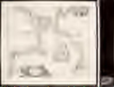
NOVA & ACCVRATA | WOLGÆ FLVMINIS
olim RHA dicti, | DELINEATIO | Auctore | ADAMO OLEARIO. [Amsterdam : Joan Blaeu]
Nova Et Accurata Wolgae Fluminis, olim RHA dicti Delineatio [Karte, Teil 2], in: Novus atlas absolutissimus, Bd. 1, S. 87.
1 Karte aus Atlas Janssonius Offizin
Obščaja geologičeskaja karta evropejskoj Rossii : List 92: Saratov - Penza
1 : 420000 sostavili I. Sintsov i S. Nikitin = Carte géologique générale de la Russie d'Europe : Feuille 92: Saratov - Pensa dressée par I. Sintzov et S. Nikitin [S.l.] : [s.n.]
Mittlerer Theil des Saratowschen Gouvernements mit den deutschen Colonieen
Russland, Saratow (Gouvernement), Wolgadeutsche
Südlicher Theil des Saratowschen Gouvernements mit dem See Elton und den Salzstrassen
Russland, Saratow (Gouvernement), Verkehrswege
Berg- und Wiesenufer von Saratow
1 : 2000000 Saratow
Der See Elton
Russland, Saratow (Gouvernement), Verkehrswege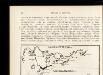
Izměnenīja za stolětīe v tečenīi rěki Sury pod Penzoj : Konec XVIII věka
Russland Pensa Umland Flusslaufverlegung
Izměnenīja za stolětīe v tečenīi rěki Sury pod Penzoj : Konec XIX věka
Russland Pensa Umland Flusslaufverlegung
Überreste der Stadt Sarai in der Nähe von Zarew, nördlich der Achtuba, eines Armes der Wolga
Sarai Archäologische Stätte, Goldene Horde
Wolga-Delta
1 : 2000000 Wolgadelta
[Nižnjaja Volga]
Volha-oblast (Rusko)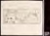
Le cours de la riviere de Wolga, anciennement appellée Rha selon la relation d'Olearius / a Leide p
1 : 2500000 1 Karte : Kupferdruck ; 23 x 58 cm Olearius, Adam chez J. Covens et C. Mortier
Governi di Moscovia e Woronez colle loro provincie nella Russia europea
1 Karte : Kupferdruck ; 41 x 32 cm Zatta; Zuliani; Pitteri presso Antonio Zatta
Governi di Moscovia e Woronez colle loro provincie nella Russia europea / G. Zuliani inc. ; G. Pitte
1 : 3500000 1 Karte : Kupferdruck ; 41 x 32 cm Zuliani, Giuliano presso Antonio Zatta
I governi di Moscovia e Woronez nell'impero della Russia in Europa / Gio. Ma. Cassini som.co. inc.
1 : 3500000 1 Karte : Kupferdruck ; 44 x 31 cm Cassini, Giovanni Maria Presso la Calcografia Camerale
Nova Et Accurata Wolgae Fluminis, olim RHA dicti Delineatio [Karte, Teil 1], in: Novus atlas absolutissimus, Bd. 1, S. 87.
1 Karte aus Atlas Janssonius Offizin
Feuille 27 (F IV), uit: Carte géologique internationale de l'Europe : la carte, votée au congrès géologique international de Bologne en 1881, est exécutée conformément aux décisions d'une commission internationale, avec le concours des gouvernements, sous le dir. de M.M. Beyrich et Hauchecorne
Annotatie: Blad 48 gamme des couleurs; blad 49: bladwijzer en titelblad Heinrich Ernst Beyrich 1815-1896; Wi. Hauchecorne Berlin : Reimer / (Berlin: Institut lithographique)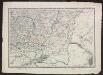
Voenno-dorožnaja karta časti Rossii i pograničnych zemelʹ
1 : 1680000 Ukraine, Don-Gebiet Šubert [Generalmajor]
Karta astrachanskoj huberniy so vključeniem' vnutrennej bukeevskoj ord'i
1 : 1680000 Astrachaň-oblast (Rusko)
Karta srednerusskoj černozemnoj oblasti
Russland Zentralrussland Topografie
Otčetnaja karta pochoda Īoanna Groznago pod Kazan' v 1552 g.
Russland Khanat Kasan Kasan Krieg Iwan IV.
Partie des Gouvernemens d'Astracan et de Woronez; le Kabarda et partie du païs des Cosaques du Don
1 : 1400000 1 Karte : Kupferdruck ; 40 x 53 cm Rizzi-Zannoni, Giovanni Antonio [Santini-Remondini]
Ostrussland
1 : 2000000 Rusko Kartographische Anstalt Freytag-Berndt u. Artaria
Partie meridionale de Moscovie / dressée par G. de L'Isle
1 : 3200000 1 Karte : Kupferdruck ; 40 x 55 cm L'Isle, Guillaume de chez Ian Barend Elwe
Moscovia, pars avstralis / auctore Isaaco Massa
1 : 3700000 1 Karte : Kupferdruck ; 36 x 48 cm Massa, Isaac Abrahamsz typis apud P. Schenk et G. Valk
Rvssiæ, vulgo Moscovia, pars australis / auctore Isaaco Massa
1 : 3910000 1 Karte : Kupferdruck ; 38 x 51 cm Blaeu, Joan Apud Johan et Cornelium Blaeu