Maps of Nigeria

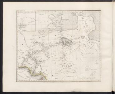
Neueste Karte von Sudan und Guinea
Grosser Hand-Atlas über alle Theile der Erde in 170 Karten Meyer, J. Verlag des Bibliographischen Instituts
Sudan, Guinea.
1 : 7250000 Radefeld, Carl Christian Franz, 1788-1874
Spezial - karte von AfricaSektion Central-Sudân (5)
1 : 4000000 1 full d'1 mapa en 10 fulls i estoig Hermann Habenicht; Justus Perthes
Spezial-Karte von Afrika
1 : 4000000 Blatt 5 Habenicht, Hermann Perthes
West Africa II.
1 : 5600000 Society for the Diffusion of Useful Knowledge (Great Britain)
Carte des découvertis faites dans le centre de l'Afrique
Afrika střední Oudeney Clapperton Gide fils
Northern Nigeria: Native Authority Areas

Map of the Colony and Protectorate of Nigeria 1929. Drawn and reproduced by the Nigeria Surveys March 1929
Nigeria Surveys
Carte de l'Afrique équatoriale française. Planche nord
1 : 5000000 Barralier, Emmanuel 18..-19.. Paris : Larose
Schutzgebiete Kamerun und Togo [in vier Blättern] Blatt 1

Dritter Deutscher Kolonialkongress 1910, Sektion IV, Karte 2

Aequatorial-West-Afrika
1 : 3000000 Kiepert, Richard ; Sprigade, Paul Geographische Verlagshandlung Dietrich Reimer
Nigeria (1907)
Outline map of Northern and Southern Nigeria, TSGS 2235. Shows major rivers, railways, boundaries and towns. Great Britain. General Staff. Topographical Section. [London] : [TSGS, War Office]
Tchad [Colonie du] (1925)
Afrique Équatoriale Française. Colonie du Tchad. Carte dressée par A. Meunier ... Échelle, 1 : 2,000,000. Paris : Union Graphique.
169. Togo, Dahomey, Nigeria. The World Atlas.
1 : 3750000 USSR (Union of Soviet Socialist Republics).
Afrique equatoriale française
1 : 2000000 Čad Meunier, Alexandre
Carte de l'Afrique occidentale française. Zinder
1 : 2000000 France. Service géographique des colonies [Paris] : Service géographique des colonies
Missions Protestantes au Cameroun.

Cameroon with Togo. Edited by Max Moisel

Kamerun
Dorsch, H.
Kamerun mit Togo 1:2 000 000
1 : 2000000 Kamerun Moisel, Max Dietrich Reimer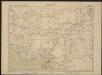
Carte de l'Afrique occidentale française. Forcados
1 : 2000000 France. Service géographique des colonies [Paris] : Service géographique des colonies
Cameroons under United Kingdom Administration

Carte du Cameroun
1 : 2000000 Kamerun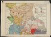
Afrique équatoriale française. Carte ethnographique. Planche nord
1 : 5000000 Paris : Larose
Lac Tchad. Afrique 22.
1 : 1641836 Vandermaelen, Philippe, 1795-1869
Vorläufige übersicht von Zintgraff's Reise von Kamerun nach dem Benuë
1 : 3500000 Kamerun C.L. Keller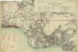
Map of the Gold Coast, Ashanti and Northern Territories
Map of the Gold Coast, Ashanti and Northern Territories, GSGS 2593. Great Britain. General Staff. Geographical Section. [London] : [GSGS, War Office]
Pays, sud du Lac Tchad. Afrique 30.
1 : 1641836 Vandermaelen, Philippe, 1795-1869