Maps of Central African Republic
Afrique équatoriale française. Carte ethnographique. Planche nord
1 : 5000000 Paris : Larose
Pays, sud du Lac Tchad. Afrique 30.
1 : 1641836 Vandermaelen, Philippe, 1795-1869
Carte du Ouadai
1 : 1000000 Čad Meunier, Alexandre Service géographique des colonies
Die Bissagos Inseln und die englischen Niederlassungen Bulama u. Riogrande auf der Westküste von Afrika
Bissagos (Guinea-Bissau) Homann, Johann Baptist Leo Africanus
[Ústí řeky Gambie]
Gambie, řeka Homann, Johann Baptist Leo Africanus
Carte du Ouadaï
1 : 1000000 Meunier, A., cartographe Paris :
Carte de l'Afrique équatoriale française. Planche nord
1 : 5000000 Barralier, Emmanuel 18..-19.. Paris : Larose
Spezial-Karte von Afrika
1 : 4000000 Blatt 5 Habenicht, Hermann Perthes
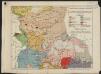
Carte géologique de l'Afrique équatoriale Franc[ai]se
1 : 5000000 Afrika střední Barralier, Emmanuel Millet
Afrique equator.le franc.se
1 : 3000000 Afrika střední Meunier, Alexandre
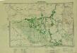
Carte du réseau fluviale navigable de l'Afrique equatoriale française
1 : 3000000 Afrika střední
Tchad [Colonie du] (1925)
Afrique Équatoriale Française. Colonie du Tchad. Carte dressée par A. Meunier ... Échelle, 1 : 2,000,000. Paris : Union Graphique.
Afrique equatoriale française
1 : 2000000 Čad Meunier, Alexandre
Schutzgebiete Kamerun und Togo [in vier Blättern] Blatt 1

Kamerun
Dorsch, H.
Cameroon with Togo. Edited by Max Moisel
Southern Sudan (1951) Seasonal Cattle Movements
Southern Sudan. Seasonal cattle movements. Corrected Nov. 1951. Topo. No. S919. Khartoum : Sudan Survey Dept.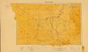
Sudan. Maṣlaḥat al-Misāḥah (1955)
[Sudan]. Sudan. Maṣlaḥat al-Misāḥah. Khartoum : Sudan Survey Department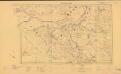
Sudan. Maṣlaḥat al-Misāḥah (1954)
Tribes [Sudan]. Sudan. Maṣlaḥat al-Misāḥah. Khartoum : Sudan Survey Department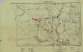
Southern Sudan (1951) Distribution of Population During Wet Season
Southern Sudan. Distribution of population during wet season. Corrected Nov. 1951. Topo. No. S. 918. Khartoum : Sudan Survey Dept.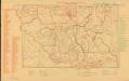
Parliamentary constituencies ― 1957 [Sudan]
Parliamentary constituencies ― 1957 [Sudan]. Sudan. Maṣlaḥat al-Misāḥah. Khartoum : Sudan Survey Department
Partie du Lac Tchad. Afrique 23.
1 : 1641836 Vandermaelen, Philippe, 1795-1869
Carta originale della Spedizione Borghese-Matteucci : nel Kordofan e Dar For secondo i rilievi del sottotenente A.M. Massari e le Esplorazioni anteriori
1 : 3000000 Cora, Guido, 1851-1917 Istituto Geografico Guido Cora
Donga. Afrique 31.
1 : 1641836 Vandermaelen, Philippe, 1795-1869
[Ohne Titel]

Pays, sud de Howssa et de Bornou. Afrique 29.
1 : 1641836 Vandermaelen, Philippe, 1795-1869
Spezial - karte von AfricaSektion Central-Sudân (5)
1 : 4000000 1 full d'1 mapa en 10 fulls i estoig Hermann Habenicht; Justus Perthes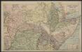
Afrique centrale. Congo-Nil
1 : 8000000 Niox, Gustave-Léon 1840-1921 Paris : Ch. Delagrave
Map of the Banso Area. Copied at the Kaiserl. Reg. St. Bamenda according to the Banso expedition map July 06. Dorsch.


