Maps of Chad

Carte de l'Afrique équatoriale française. Planche nord
1 : 5000000 Barralier, Emmanuel 18..-19.. Paris : Larose
Tchad [Colonie du] (1925)
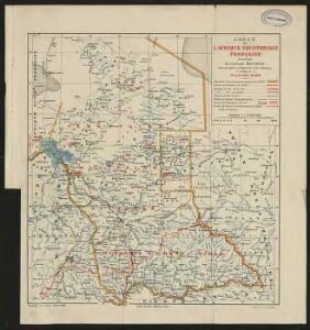
Afrique Équatoriale Française. Colonie du Tchad. Carte dressée par A. Meunier ... Échelle, 1 : 2,000,000. Paris : Union Graphique.
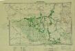
Afrique equatoriale française
1 : 2000000 Čad Meunier, Alexandre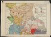
Afrique équatoriale française. Carte ethnographique. Planche nord
1 : 5000000 Paris : Larose
Pays, sud du Lac Tchad. Afrique 30.
1 : 1641836 Vandermaelen, Philippe, 1795-1869
Partie du Lac Tchad. Afrique 23.
1 : 1641836 Vandermaelen, Philippe, 1795-1869
Carte du Ouadai
1 : 1000000 Čad Meunier, Alexandre Service géographique des colonies
Carta originale della Spedizione Borghese-Matteucci : nel Kordofan e Dar For secondo i rilievi del sottotenente A.M. Massari e le Esplorazioni anteriori
1 : 3000000 Cora, Guido, 1851-1917 Istituto Geografico Guido Cora
[Ohne Titel]

Carte du Ouadaï
1 : 1000000 Meunier, A., cartographe Paris :
Die Bissagos Inseln und die englischen Niederlassungen Bulama u. Riogrande auf der Westküste von Afrika
Bissagos (Guinea-Bissau) Homann, Johann Baptist Leo Africanus
[Ústí řeky Gambie]
Gambie, řeka Homann, Johann Baptist Leo Africanus
Spezial - karte von AfricaSektion Central-Sudân (5)
1 : 4000000 1 full d'1 mapa en 10 fulls i estoig Hermann Habenicht; Justus Perthes
Afrique equator.le franc.se
1 : 3000000 Afrika střední Meunier, Alexandre
Carte du réseau fluviale navigable de l'Afrique equatoriale française
1 : 3000000 Afrika střední
Carte géologique de l'Afrique équatoriale Franc[ai]se
1 : 5000000 Afrika střední Barralier, Emmanuel Millet
Spezial-Karte von Afrika
1 : 4000000 Blatt 5 Habenicht, Hermann Perthes
Sudan, Guinea.
1 : 7250000 Radefeld, Carl Christian Franz, 1788-1874
Neueste Karte von Sudan und Guinea
Grosser Hand-Atlas über alle Theile der Erde in 170 Karten Meyer, J. Verlag des Bibliographischen Instituts
The Anglo-Egyptian Sudan
1 : 3000000 Súdán Ordnance survey office
The Anglo-Egyptian Sudan
1 : 3000000 Súdán War Office
Schutzgebiete Kamerun und Togo [in vier Blättern] Blatt 1
Carte des découvertis faites dans le centre de l'Afrique
Afrika střední Oudeney Clapperton Gide fils
Cameroon with Togo. Edited by Max Moisel

Kamerun
Dorsch, H.
Dritter Deutscher Kolonialkongress 1910, Sektion IV, Karte 2

West Africa II.
1 : 5600000 Society for the Diffusion of Useful Knowledge (Great Britain)
Missions Protestantes au Cameroun.

Kamerun mit Togo 1:2 000 000
1 : 2000000 Kamerun Moisel, Max Dietrich Reimer