Maps of Adamawa Plateau

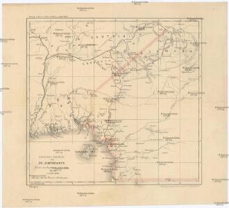
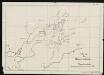
Vorläufige übersicht von Zintgraff's Reise von Kamerun nach dem Benuë
1 : 3500000 Kamerun C.L. Keller
Carte de l'Afrique occidentale française. Forcados
1 : 2000000 France. Service géographique des colonies [Paris] : Service géographique des colonies
Localisatin of ethnic groups. Southern section. Sheet XI

Nigeria
Map of the Gold Coast, Ashanti and Northern Territories
Map of the Gold Coast, Ashanti and Northern Territories, GSGS 2593. Great Britain. General Staff. Geographical Section. [London] : [GSGS, War Office]
Map of the south-western part of Cameroon (containing the Basel Mission area)
Route sketch of H. Ramsay's expedition in the southern Cameroon regions

Stationen und Arbeitsgebiete der Basler Mission im Grasland v. Kamerun
Tischhauser, G.
Karte des Kamerun-Gebiets

The Lower Niger to the Confluence

Map of Cameroon, edited by M. Moisel. E2. Banjo.
Sketch of the Bassa region.
Autenrieth
Karte des Gebiets zwischen Bali und Nyasoso, zum Reisebericht Br. Dorsch's
Dorsch, H.
The northern Bulu region according to the survey by First Lieutenant von Glisczinski, Lieutenant Nolte und Dr. Bennett in 1897 and 1898. Designed and drawn by Max Moisel. (Mittheilungen aus den deutschen Schutzgebieten)

Stationsgebiet Mangamba, entworfen nach der Karte von Dr. Esch - Die Flussgebiete des Mongo u. Unteren Wuri.
Dinkelacker, E.
Carte de Fernando Póo según Pellon / adicionada por los P.F. Misioneros Hijos del I.C. de María
1 Mapa. Pellón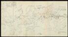
Skizzen aus meinen Reisen in Basa.
Nuevo mapa de la isla de Fernando Póo, vicariato Apostólico
1 Mapa, col. Finestra: Plano de Sta. Isabel Sucesores de Henricy y Ca.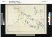
The Cameroon Basin and its feeding rivers. Sheet no. 2. The Wuri & Abo..

[kein Titel]
J. Ittmann
Karte der Pflanzungsgesellschaften (nach Moisel).

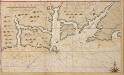
Old Calabar River; from sketch surveys 1869-90.
Old Calabar River; from sketch surveys 1869-90. Natural Scale, 1 : 137,400. [Admiralty Chart] London
Karte der Insel Fernando Póo
1 : 200000 Baumann, Oscar Eduard Hölzel
untitled
Afteekening van Rio Roijaal geleegen in Gunea beooste de bogt van Benin
Nigeria Gerard van Keulen
[kein Titel]

General overview of the new site in Douala. Copy

Sketch of the roads to Buea. With a letter by S. Keller, dated 18. September 1901.
Darthner
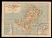
Basel Mission Plot Bali, Bamenda Divisions British Cameroon.