Maps of Nigeria

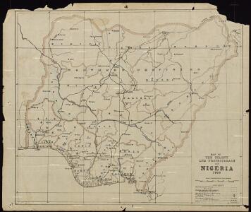
Map of the Colony and Protectorate of Nigeria 1929. Drawn and reproduced by the Nigeria Surveys March 1929
Nigeria Surveys
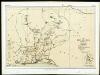
Northern Nigeria: Native Authority Areas

Nigeria (1907)
Outline map of Northern and Southern Nigeria, TSGS 2235. Shows major rivers, railways, boundaries and towns. Great Britain. General Staff. Topographical Section. [London] : [TSGS, War Office]
169. Togo, Dahomey, Nigeria. The World Atlas.
1 : 3750000 USSR (Union of Soviet Socialist Republics).
Dritter Deutscher Kolonialkongress 1910, Sektion IV, Karte 2
Carte de l'Afrique occidentale française. Forcados
1 : 2000000 France. Service géographique des colonies [Paris] : Service géographique des colonies
Missions Protestantes au Cameroun.

Cameroons under United Kingdom Administration

Carte du Cameroun
1 : 2000000 Kamerun
Vorläufige übersicht von Zintgraff's Reise von Kamerun nach dem Benuë
1 : 3500000 Kamerun C.L. Keller
Partie, la Guinee. Afrique 28.
1 : 1641836 Vandermaelen, Philippe, 1795-1869
Kolonien (Schutzgebiete) des Deutschen Reichs
1 : 6000000 Afrika jihozápadní F.A. Brockhaus Geogr.-artist. Anstalt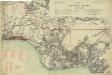
Map of the Gold Coast, Ashanti and Northern Territories
Map of the Gold Coast, Ashanti and Northern Territories, GSGS 2593. Great Britain. General Staff. Geographical Section. [London] : [GSGS, War Office]
Nigeria
Die Oku-Länder (Yoruba)

The Lower Niger to the Confluence

Pays, sud de Howssa et de Bornou. Afrique 29.
1 : 1641836 Vandermaelen, Philippe, 1795-1869
Map of the south-western part of Cameroon (containing the Basel Mission area)

Localisatin of ethnic groups. Southern section. Sheet XI

[Ohne Titel]

Mission du Commandant Decoeur entre le Dahomey et le Niger
1 : 100000 Decoeur [Paris] :
Golfe du Guinee. Afrique 36.
1 : 1641836 Vandermaelen, Philippe, 1795-1869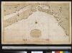
Een gedeelte van de kust van Gunea van Accara tot C. Formosa vertoonende de Bogt van Benin
Ghana Gerard van Keulen
Carte du Haut-Dahomey
1 : 1180000 Chambre de commerce internationale. Comité de l'Afrique française [Paris] : Comité de l'Afrique française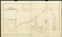
Route sketch of H. Ramsay's expedition in the southern Cameroon regions

Carte des colonies de l'A.O.F. Dosso
1 : 500000 Afrique occidentale française. Service géographique Paris : Blondel la Rougery
Stationen und Arbeitsgebiete der Basler Mission im Grasland v. Kamerun
Tischhauser, G.
Karte des Kamerun-Gebiets

Map of Cameroon, edited by M. Moisel. E2. Banjo.