Maps of Benin

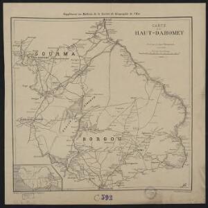
Carte du Haut-Dahomey
1 : 1180000 Chambre de commerce internationale. Comité de l'Afrique française [Paris] : Comité de l'Afrique française
Carte des colonies de l'A.O.F. Nikki
1 : 500000 Afrique occidentale française. Service géographique Paris : Blondel la Rougery
Mission du Commandant Decoeur entre le Dahomey et le Niger
1 : 100000 Decoeur [Paris] :
Partie, la Guinee. Afrique 28.
1 : 1641836 Vandermaelen, Philippe, 1795-1869
Karte von Togo
1 : 200000 Togo Sprigade, Paul Mittler & Sohn
Carte des colonies de l'A.O.F. Dosso
1 : 500000 Afrique occidentale française. Service géographique Paris : Blondel la Rougery
Map of Togo. A1. Sansane-Mangu
169. Togo, Dahomey, Nigeria. The World Atlas.
1 : 3750000 USSR (Union of Soviet Socialist Republics).
Carte de la boucle du Niger / dressée par Spicq ; Service Géographique des Colonies
1 : 1500000 Annotatie: Met Index alfabetique (76 p.) Henri Eugène Spicq; Service Géographique des Colonies Paris : Maison Andriveau-Goujon, Henri Barrère
The River Niger.
1 : 3400000 Arrowsmith, John
Carte des découvertis faites dans le centre de l'Afrique
Afrika střední Oudeney Clapperton Gide fils
West Africa II.
1 : 5600000 Society for the Diffusion of Useful Knowledge (Great Britain)
Odumase und Aussenstationen

Northern Nigeria: Native Authority Areas

Togo

Map of the Colony and Protectorate of Nigeria 1929. Drawn and reproduced by the Nigeria Surveys March 1929
Nigeria Surveys
Carte de l'Afrique occidentale française. Bingerville, Porto-Novo
1 : 2000000 France. Service géographique des colonies [Paris] : Service géographique des colonies
Nigeria (1907)
Outline map of Northern and Southern Nigeria, TSGS 2235. Shows major rivers, railways, boundaries and towns. Great Britain. General Staff. Topographical Section. [London] : [TSGS, War Office]
Die Goldküste und Togo.
Carte de l'Afrique occidentale française. Tombouctou
1 : 2000000 France. Service géographique des colonies [Paris] : Service géographique des colonies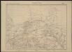
Carte de l'Afrique occidentale française. Tombouctou
1 : 2000000 France. Service géographique des colonies [Paris] : Service géographique des colonies
Die Goldküste und Togo. Uebersichtskarte mit den Missionsstationen der Basler- und der Norddeutschen Missionsgesellschaft

Timbouctou. Afrique 21.
1 : 1641836 Vandermaelen, Philippe, 1795-1869
56 Nant, Millaud.
1 : 86400 Cassini family; Cassini, Cesar-Francois, 1714-1784
The Gold Coast with Togoland under British Mandate
Huppenbauer
Die Oku-Länder (Yoruba)

Ghana Road Map (North) 1957
Road map of Ghana, GSGS 4903. Later redesignated as Series G451. Great Britain. War Office. [London] : D. Survey, War Office & Air Ministry.
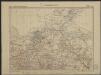
Skizze der topographischen Aufnahmen in der Umgebung von Bismarckburg durch Premierleutnant von Doering 1893 - 95

Aequatorial-West-Afrika
1 : 3000000 Kiepert, Richard ; Sprigade, Paul Geographische Verlagshandlung Dietrich Reimer