Maps of Benin

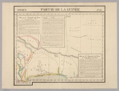
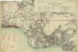
Partie, la Guinee. Afrique 28.
1 : 1641836 Vandermaelen, Philippe, 1795-1869
Mission du Commandant Decoeur entre le Dahomey et le Niger
1 : 100000 Decoeur [Paris] :
Die Oku-Länder (Yoruba)

Carte du Haut-Dahomey
1 : 1180000 Chambre de commerce internationale. Comité de l'Afrique française [Paris] : Comité de l'Afrique française
The Lower Niger to the Confluence

Karte von Togo
1 : 200000 Togo Sprigade, Paul Mittler & Sohn
Carte des colonies de l'A.O.F. Nikki
1 : 500000 Afrique occidentale française. Service géographique Paris : Blondel la Rougery
Mission au Dahomey (21 novembre-28 décembre 1889). Itinéraire suivi par M. Bayol de Kotonou à Abomey
1 : 200000 [Paris] : service géographique des colonies
Carte du Bas-Dahomey. Ouidah
1 : 100000 Afrique occidentale française. Service géographique [Dakar] : Service géographique de l'A. O. F
Afrique occidentale française-carte régulière. Grand-Popo
1 : 100000 Afrique occidentale française. Service géographique [Dakar] : Service géographique de l'A. O. F.
Afrique occidentale française-carte régulière. Cotonou
1 : 100000 Afrique occidentale française. Service géographique [Dakar] : Service géographique de l'A. O. F.
Afrique occidentale française-carte régulière. Porto-Novo
1 : 100000 Afrique occidentale française. Service géographique [Dakar] : Service géographique de l'A. O. F.
Afrique occidentale française-carte régulière. Parahoué
1 : 100000 Afrique occidentale française. Service géographique [Dakar] : Service géographique de l'A. O. F.
Afrique occidentale française-carte régulière. Allada
1 : 100000 Afrique occidentale française. Service géographique [Dakar] : Service géographique de l'A. O. F.
Afrique occidentale française-carte régulière. Pobé
1 : 100000 Afrique occidentale française. Service géographique [Dakar] : Service géographique de l'A. O. F.
Carte du Bas-Dahomey. Porto-Novo
1 : 100000 Afrique occidentale française. Service géographique [Dakar] : Service géographique de l'A. O. F
Carte du Bas-Dahomey. Grand-Popo
1 : 100000 Afrique occidentale française. Service géographique [Dakar] : Service géographique de l'A. O. F
Carte du Bas-Dahomey. Grand-Popo
1 : 100000 Afrique occidentale française. Service géographique [Dakar] : Service géographique de l'A.O.F.
Layout of Ikoyi

Skizze der topographischen Aufnahmen in der Umgebung von Bismarckburg durch Premierleutnant von Doering 1893 - 95

Karte von Togo. E1. Misahöhe.
169. Togo, Dahomey, Nigeria. The World Atlas.
1 : 3750000 USSR (Union of Soviet Socialist Republics).
Map of the Colony and Protectorate of Nigeria 1929. Drawn and reproduced by the Nigeria Surveys March 1929
Nigeria Surveys
Nigeria (1907)
Outline map of Northern and Southern Nigeria, TSGS 2235. Shows major rivers, railways, boundaries and towns. Great Britain. General Staff. Topographical Section. [London] : [TSGS, War Office]
Togo
Map of the Gold Coast, Ashanti and Northern Territories
Map of the Gold Coast, Ashanti and Northern Territories, GSGS 2593. Great Britain. General Staff. Geographical Section. [London] : [GSGS, War Office]
Carte de l'Afrique occidentale française. Forcados
1 : 2000000 France. Service géographique des colonies [Paris] : Service géographique des colonies
Odumase und Aussenstationen

Die Goldküste und Togo.