Maps of Togo

Karte von Togo
1 : 200000 Togo Sprigade, Paul Mittler & Sohn
Skizze der topographischen Aufnahmen in der Umgebung von Bismarckburg durch Premierleutnant von Doering 1893 - 95

Karte von Togo. E1. Misahöhe.

Distanzenzeiger für Anum

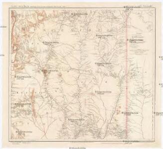
Map of Togo. A1. Sansane-Mangu

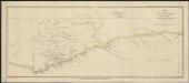
Südliches Wolta-Gebiet auf der Goldküste von West-Afrika
Atlas der evangelischen Missions-Gesellschaft zu Basel Locher; Gross, Rudolf Im Verlag des Comptoires der evangelischen Missions-Gesellschaft
Sketch Map of the Divisions in the Gold Coast Protectorate
Akuse (Gold Coast)

Anum Stationsgebiet gez. Von R. Bürki Missionar

Abokobi

Afrique occidentale française-carte régulière. Grand-Popo
1 : 100000 Afrique occidentale française. Service géographique [Dakar] : Service géographique de l'A. O. F.
Afrique occidentale française-carte régulière. Parahoué
1 : 100000 Afrique occidentale française. Service géographique [Dakar] : Service géographique de l'A. O. F.
Carte du Bas-Dahomey. Grand-Popo
1 : 100000 Afrique occidentale française. Service géographique [Dakar] : Service géographique de l'A. O. F
Carte du Bas-Dahomey. Grand-Popo
1 : 100000 Afrique occidentale française. Service géographique [Dakar] : Service géographique de l'A.O.F.
The Gold Coast - Accra
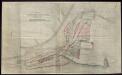
Gold Coast Colony. Plan of Christiansborg

Accra / Reference No. X2270/159 / Sheet 159
Accra Harbour Works Improvements. Proposed Improvements shown in red

Togo

Die Goldküste und Togo.

Die Goldküste und Togo. Uebersichtskarte mit den Missionsstationen der Basler- und der Norddeutschen Missionsgesellschaft

Mission du Commandant Decoeur entre le Dahomey et le Niger
1 : 100000 Decoeur [Paris] :
The Gold Coast with Togoland under British Mandate
Huppenbauer
Die Missionen auf der Gold-Küste und Sklaven-Küste

Mohamm. Händler auf der Goldküste

östlicher Teil der Gold-KüsteBasler Missions-Gebiet

Kaart van de Goud-Kust of Kust van Guinea / door Js. van den Bosch ; gegraveerd door C. van Baarsel en Zoon
C. van Baarsel en Zoon s-Gravenhage ; Amsterdam : Gebroeders van Cleef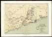
The mission fields on the Gold Coast and the western parts of the Slave Coast
Map of the Gold Coast : to accompany Dr. Madden's report
1 : 1250000 John Arrowsmith, lith. [London] : James & Luke J. Hansard, printers