Maps of Ghana

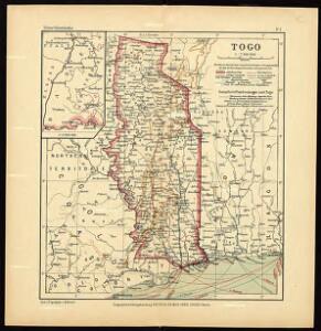
Togo

Die Goldküste und Togo.

Die Goldküste und Togo. Uebersichtskarte mit den Missionsstationen der Basler- und der Norddeutschen Missionsgesellschaft

The Gold Coast with Togoland under British Mandate
Huppenbauer
Mission du Commandant Decoeur entre le Dahomey et le Niger
1 : 100000 Decoeur [Paris] :
Die Missionen auf der Gold-Küste und Sklaven-Küste

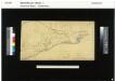
Karte von Togo
1 : 200000 Togo Sprigade, Paul Mittler & Sohn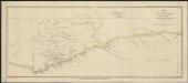
Map of the Gold Coast : to accompany Dr. Madden's report
1 : 1250000 John Arrowsmith, lith. [London] : James & Luke J. Hansard, printers
Mohamm. Händler auf der Goldküste

östlicher Teil der Gold-KüsteBasler Missions-Gebiet
The mission fields on the Gold Coast and the western parts of the Slave Coast

Kaart van de Goud-Kust of Kust van Guinea / door Js. van den Bosch ; gegraveerd door C. van Baarsel en Zoon
C. van Baarsel en Zoon s-Gravenhage ; Amsterdam : Gebroeders van Cleef
Ghana Road Map (North) 1957
Road map of Ghana, GSGS 4903. Later redesignated as Series G451. Great Britain. War Office. [London] : D. Survey, War Office & Air Ministry.
Ghana Road Map (South) 1957
Road map of Ghana, GSGS 4903. Later redesignated as Series G451. Great Britain. War Office. [London] : D. Survey, War Office & Air Ministry.
Eastern District of the Gold Coast. The Head-Stations and the Out-Stations of the Basel Mission are underlined
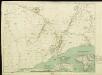
Geological Map of the Gold Coast. Southern Sheet. Showing Positions of Gold Mines and Prospects
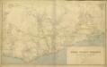
Map of the Gold Coast Colony and neighbouring territories
Map of the Gold Coast Colony and neighbouring territories, IDWO 1097. Great Britain. War Office. Intelligence Division. [London] : [War Office, Intelligence Division].
Die Goldküste und westliche Sklavenküste sowie das südliche Asante Reich in Westafrika
Atlas der evangelischen Missions-Gesellschaft zu Basel Locher; Gross, Rudolf Im Verlag des Comptoires der evangelischen Missions-Gesellschaft
Eastern-District of the Gold Coast
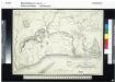
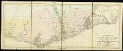
The Danish Gold Coast and Guinea
A Map of the Gold Coast and Inland Countries between and beyond the Pra and Volta by the Basel Missionaries on the Gold Coast

The Gold Coast of Africa.
Dorsch
Skizze der topographischen Aufnahmen in der Umgebung von Bismarckburg durch Premierleutnant von Doering 1893 - 95
Sketch Map of the Divisions in the Gold Coast Protectorate

Carte du Haut-Dahomey
1 : 1180000 Chambre de commerce internationale. Comité de l'Afrique française [Paris] : Comité de l'Afrique française
Carte des colonies de l'A.O.F. Tenkodogo
1 : 500000 Afrique occidentale française. Service géographique Paris : Blondel la Rougery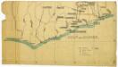
Untitled
Special map of the inland countries on the Gold Coast up to Kumasi, an Anglo-African theater of war in 1874. By A. Petermann

Distanzenzeiger für Anum