Maps of Gold Coast
The mission fields on the Gold Coast and the western parts of the Slave Coast

Kaart van de Goud-Kust of Kust van Guinea / door Js. van den Bosch ; gegraveerd door C. van Baarsel en Zoon
C. van Baarsel en Zoon s-Gravenhage ; Amsterdam : Gebroeders van Cleef
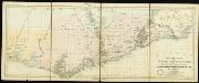
Map of the Gold Coast : to accompany Dr. Madden's report
1 : 1250000 John Arrowsmith, lith. [London] : James & Luke J. Hansard, printers
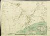
Map of the Gold Coast Colony and neighbouring territories
Map of the Gold Coast Colony and neighbouring territories, IDWO 1097. Great Britain. War Office. Intelligence Division. [London] : [War Office, Intelligence Division].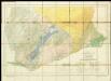
Geological Map of the Gold Coast. Southern Sheet. Showing Positions of Gold Mines and Prospects
Untitled

Mohamm. Händler auf der Goldküste

Ghana Road Map (South) 1957
Road map of Ghana, GSGS 4903. Later redesignated as Series G451. Great Britain. War Office. [London] : D. Survey, War Office & Air Ministry.
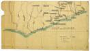
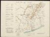
östlicher Teil der Gold-KüsteBasler Missions-Gebiet

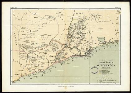
Die Goldküste und westliche Sklavenküste sowie das südliche Asante Reich in Westafrika
Atlas der evangelischen Missions-Gesellschaft zu Basel Locher; Gross, Rudolf Im Verlag des Comptoires der evangelischen Missions-Gesellschaft
Eastern-District of the Gold Coast
Special map of the inland countries on the Gold Coast up to Kumasi, an Anglo-African theater of war in 1874. By A. Petermann
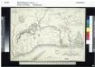
The Danish Gold Coast and Guinea
A Map of the Gold Coast and Inland Countries between and beyond the Pra and Volta by the Basel Missionaries on the Gold Coast

The Gold Coast of Africa.
Dorsch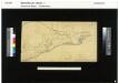
Sketch Map of the Divisions in the Gold Coast Protectorate

Distanzenzeiger für Anum

Karte von Togo. E1. Misahöhe.

Südliches Wolta-Gebiet auf der Goldküste von West-Afrika
Atlas der evangelischen Missions-Gesellschaft zu Basel Locher; Gross, Rudolf Im Verlag des Comptoires der evangelischen Missions-Gesellschaft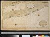
Een gedeelte van de kust van Gunea van C. Corso tot Accara vertoonende 't Oostelijkste van de Goudkust int groot
Ghana Pieter Hinke Gerard van Keulen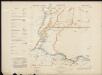
Akuse (Gold Coast)
Accra (Gold Coast)

Mission au Dahomey (21 novembre-28 décembre 1889). Itinéraire suivi par M. Bayol de Kotonou à Abomey
1 : 200000 [Paris] : service géographique des colonies
Een gedeelte van de kust van Gunea van C. Trespuntas tot C. Corso : vertoonende t Westelijkste van de Goutkust
Ghana Pieter Hinke Gerard van Keulen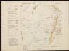
Kibbi (Kyebi) Gold Coast

Anum Stationsgebiet gez. Von R. Bürki Missionar
Gold Coast (1911)
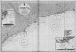
[Africa. West Coast. Gold Coast. Achowa Point to Cape Coast Castle. Surveyed ... 1837]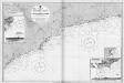
Gold Coast (1920)
[Africa. West Coast. Gold Coast. Achowa Point to Cape Coast Castle. Surveyed ... 1837]
Abokobi