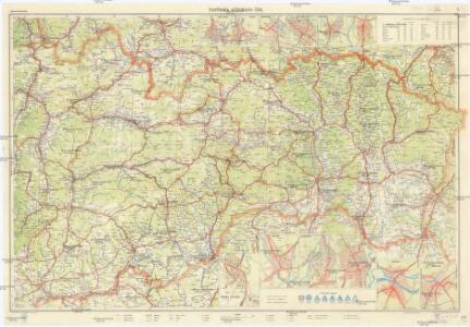
Maps of Eastern Slovakia

Východní Slovensko
1 : 300000 Banská Štiavnica (Slovensko) Fastr Eduard
Východné Slovensko
1 : 300000 Banská Štiavnica (Slovensko) Edv. Fastr
Mappa generalis regni Hungariae partiumque adnexarum Croatiae, Slavoniae...

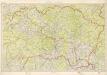
Ober Ungern
Slovensko východní Kipferling, Karl Joseph Müller, Karl im Verlage des Kunst und Industrie Comptoir's
Ober Ungern
Slovensko východní Kipferling, Karl Joseph Müller, Karl im Verlage des Kunst und Industrie Comptoir's
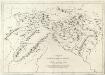
Augustissimo Romanor. Imperatori Iosepho I. Hungaria Regi Invictissimo Mappam Hanc Regni Hungariae
1 : 540000 Mollova mapová sbírka Müller, Johann Christoph
Die Donau, der Fürst aller Europaeischen Flüsse :
Mollova mapová sbírka Hoffmann, Johannes Hoffmann, Johann
Vermehrte und Verbesserte Landkarten des Königreichs Ungarn :
1 : 500000 Mollova mapová sbírka Stier, Martin Böner, Johann-Alexander Endter, Martin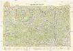
Neubertova generální automapa Republiky československé
1 : 200000 Košice (Slovensko : oblast) Soukup, Jan V. Neubert a synové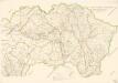
Bez titulu: mapy slovenských krajů
Kraj Košický a Prešovský
Appendix ad Mappam Mineralographicam
Mollova mapová sbírka Marsili, Luigi Ferdinando
Comitat Abaúj-Torna
1 : 290000 Košice (Slovensko : oblast)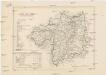
Comitat Abaúj-Torna
1 : 288000 Košice-oblast jižní (Slovensko)
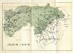
Zipser Comitat
1 : 280000 Spiš (Slovensko)
Stredoslovenský kraj

Slovensko
Stolice Zvolen a Gemer
Komitat Altsohl, Komitat Gemer, ethnische Gruppe
Československo v mapách

Die im Stadtbuch von Zipser Neudorf genannten Orte
Zips, Spišská Nová Ves, Stadtbuch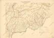
Bez titulu: mapy slovenských krajů

Kraj banskobystrický
Stolice Spiš. Stolice Šaryš
Šariš, Komitat Zips, ethnische Gruppe
Zemplén vármegye térképe
1 : 470000 Zemplín (Slovensko a Maďarsko) Kogutowicz, Manó Magyar Földrajzi Intézet
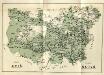
Stolice Zemplín a Užhorod
Užhorod (Ukrajina)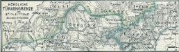
Nördliche Türkengrenze im 16ten u. 17ten Jhdt.
1 : 1850000 Osmanisches Reich / Europäischer Teil Grenze
Bez titulu: mapy slovenských krajů

Stolice Zemplín a Užhorod
Komitat Zemplín, Komitat Uschgorod, ethnische Gruppe
Kraj žilinský