Maps of Észak-Magyarország

Vermehrte und Verbesserte Landkarten des Königreichs Ungarn :
1 : 500000 Mollova mapová sbírka Stier, Martin Böner, Johann-Alexander Endter, Martin
Ober Ungern
Slovensko východní Kipferling, Karl Joseph Müller, Karl im Verlage des Kunst und Industrie Comptoir's
Ober Ungern
Slovensko východní Kipferling, Karl Joseph Müller, Karl im Verlage des Kunst und Industrie Comptoir's
Die Donau, der Fürst aller Europaeischen Flüsse :
Mollova mapová sbírka Hoffmann, Johannes Hoffmann, Johann
Sbírka map a diagramů použitých na mírových konferencích v Paříži v letech 1919 - 1920
Sbírka map a diagramů použitých na mírových konferencích v Paříži v letech 1919 - 1920

Východní Slovensko
1 : 300000 Banská Štiavnica (Slovensko) Fastr Eduard
Východné Slovensko
1 : 300000 Banská Štiavnica (Slovensko) Edv. Fastr
A szlovákok településterülete a szomszédsági mutató alapján Északkelet-Magyarországon 1941-ban
Ungarn (Nordost) Slowaken, Siedlung Bottlik, Zsolt
A szlovákok településterülete a szomszédsági mutató alapján Északkelet-Magyarországon 1880-ban
Ungarn (Nordost) Slowaken, Siedlung Bottlik, Zsolt
A szlovákok településterülete a szomszédsági mutató alapján Északkelet-Magyarországon 1980-ban
Ungarn (Nordost) Slowaken, Siedlung Bottlik, Zsolt
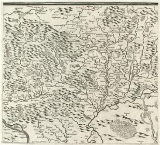
Comitat Abaúj-Torna
1 : 290000 Košice (Slovensko : oblast)
Comitat Abaúj-Torna
1 : 288000 Košice-oblast jižní (Slovensko)
Neubertova generální automapa Republiky československé
1 : 200000 Debrecín (Maďarsko : oblast) Soukup, Jan V. Neubert a synové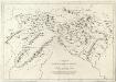
Appendix ad Mappam Mineralographicam
Mollova mapová sbírka Marsili, Luigi Ferdinando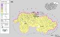
Siedlungsgebiet der Slowaken nach dem Nachbarschaftsindex für Nordost-Ungarn 1880
Ungarn (Nordost) Slowaken, Siedlung Bottlik, Zsolt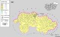
Siedlungsgebiet der Slowaken nach dem Nachbarschaftsindex für Nordost-Ungarn 1980
Ungarn (Nordost) Slowaken, Siedlung Bottlik, Zsolt
Siedlungsgebiet der Slowaken nach dem Nachbarschaftsindex für Nordost-Ungarn 1941
Ungarn (Nordost) Slowaken, Siedlung Bottlik, Zsolt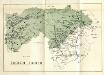
Stolice Zvolen a Gemer
Komitat Altsohl, Komitat Gemer, ethnische Gruppe
Bez titulu: mapy slovenských krajů

Gömör vármegye és a' vele törvényesen egyesült Kis-Honti kerület
1 : 240000 Gemer (Slovensko : oblast) Ráisz, Christ. Benedicti, Hieronymus Görög
Kraj banskobystrický

Rima-Szombat 135, uit: Special-Karte von Mittel-Europa / nach amtlichen Quellen bearbeitet von W. Liebenow
1 : 300000 titelvariant: W. Liebenow's Mittel-Europa; Annotatie: Titel boven de bladen: W. Liebenow's Mittel-Europa Johannes Wilhelm Liebenow 1822-1897 Frankfurt a. M. : Ludwig Ravenstein
Stolice Abauj-Torna a Boršod
Abaúj-Torna, Komitat Borsod, ethnische Gruppe

C. Borsodiensis
Ungarn Komitat Borsod

Zipser Comitat
1 : 280000 Spiš (Slovensko)
Miskolcz 136, uit: Special-Karte von Mittel-Europa / nach amtlichen Quellen bearbeitet von W. Liebenow
1 : 300000 titelvariant: W. Liebenow's Mittel-Europa; Annotatie: Titel boven de bladen: W. Liebenow's Mittel-Europa Johannes Wilhelm Liebenow 1822-1897 Frankfurt a. M. : Ludwig Ravenstein