Maps of Borsod-Abaúj-Zemplén

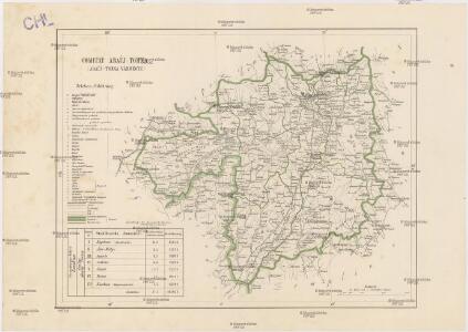
Comitat Abaúj-Torna
1 : 290000 Košice (Slovensko : oblast)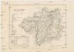
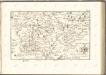
Comitat Abaúj-Torna
1 : 288000 Košice-oblast jižní (Slovensko)
Nördliche Türkengrenze im 16ten u. 17ten Jhdt.
1 : 1850000 Osmanisches Reich / Europäischer Teil Grenze
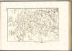
Stolice Abauj-Torna a Boršod
Abaúj-Torna, Komitat Borsod, ethnische Gruppe
Stolice Zvolen a Gemer
Komitat Altsohl, Komitat Gemer, ethnische Gruppe
Rima-Szombat 135, uit: Special-Karte von Mittel-Europa / nach amtlichen Quellen bearbeitet von W. Liebenow
1 : 300000 titelvariant: W. Liebenow's Mittel-Europa; Annotatie: Titel boven de bladen: W. Liebenow's Mittel-Europa Johannes Wilhelm Liebenow 1822-1897 Frankfurt a. M. : Ludwig Ravenstein
Zipser Comitat
1 : 280000 Spiš (Slovensko)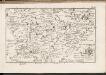
C. Tornensis
Ungarn Komitat Torna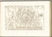

C. Gömöriensis
Slowakei Komitat Gemer
C. Abaujvár
Slowakei Ungarn Abaúj-Torna
Gömör vármegye és a' vele törvényesen egyesült Kis-Honti kerület
1 : 240000 Gemer (Slovensko : oblast) Ráisz, Christ. Benedicti, Hieronymus Görög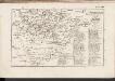
C. Zempliniensis. Tab. II
Slowakei Komitat Zemplín
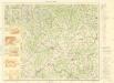
Miskolcz 136, uit: Special-Karte von Mittel-Europa / nach amtlichen Quellen bearbeitet von W. Liebenow
1 : 300000 titelvariant: W. Liebenow's Mittel-Europa; Annotatie: Titel boven de bladen: W. Liebenow's Mittel-Europa Johannes Wilhelm Liebenow 1822-1897 Frankfurt a. M. : Ludwig Ravenstein
Borsod vármegye
1 : 410000 Görög, Demeter Biller, Bernhard Görög
Borsoder Comitat
1 : 288000
Borsoder Comitat
1 : 288000
C. Borsodiensis
Ungarn Komitat Borsod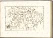

Mappa Comitatvs Neogradiensis Methodo Astronomico-Geometrica concinnata
1 : 166600 Mollova mapová sbírka Mikoviny, Sámuel Nicolaï, Georg David Christoph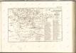

Abauj-Torna vármegye térképe
1 : 380000 Košice (Slovensko : oblast) Kogutowicz, Manó Magyar Földrajzi Intézet
Kaschau (Ungarn). Small #9918
from Spezialkarte der osterreichisch-ungarischen Monarchie.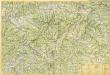
Slovenské rudohorie
Lučenec a okolie

Nagy-Rocze und Rimm-Banya (Ungarn).
from Spezialkarte der osterreichisch-ungarischen Monarchie.
Kassa (Kaschau) (Ungarn). #9916
from Spezialkarte der osterreichisch-ungarischen Monarchie.