Maps of Košický

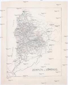
Stolice Zemplín a Užhorod
Užhorod (Ukrajina)
Stolice Zemplín a Užhorod
Komitat Zemplín, Komitat Uschgorod, ethnische Gruppe
Zemplén vármegye térképe
1 : 470000 Zemplín (Slovensko a Maďarsko) Kogutowicz, Manó Magyar Földrajzi Intézet

Comitat Ungh
1 : 285000 Užhorod (Ukrajina)
C. Ungvár
Slowakei Ukraine Komitat Uschgorod
Normální mezinárodní letecká mapa.

Kaschau 122, uit: Special-Karte von Mittel-Europa / nach amtlichen Quellen bearbeitet von W. Liebenow
1 : 300000 titelvariant: W. Liebenow's Mittel-Europa; Annotatie: Titel boven de bladen: W. Liebenow's Mittel-Europa Johannes Wilhelm Liebenow 1822-1897 Frankfurt a. M. : Ludwig Ravenstein
Sväzok dokladov... prác na štátnej hranici medzi Československou republikou a Sväzom sovietských republik, ...

Sväzok dokladov... prác na štátnej hranici medzi Československou republikou a Sväzom sovietských republik, ...

Sväzok dokladov... prác na štátnej hranici medzi Československou republikou a Sväzom sovietských republik, ...

Comitat Beregh-Ugocsa
1 : 288000 Mukačevo (Ukrajina)
Comitat Beregh-Ugocsa
1 : 290000 Berehove (Ukrajina : oblast)

Ung vármegye térképe
1 : 310000 Slovensko Kogutowicz, Manó Magyar Földrajzi Intézet
Ung-vármegye térképe
1 : 310000 Slovensko Magyar Földrajzi Intézet
Sväzok dokladov... prác na štátnej hranici medzi Československou republikou a Sväzom sovietských republik, ...

Hranice Rusů, Mad'arů a Slováků v Užhorodě
Uschhorod ethnische Gruppe
Varanno.
from Spezialkarte der osterreichisch-ungarischen Monarchie.
Ungvar.
from Spezialkarte der osterreichisch-ungarischen Monarchie.
Toketerebes und Nagyszalancz.
from Spezialkarte der osterreichisch-ungarischen Monarchie.
Saros-Nagypatak und Satoralja-Ujhely.
from Spezialkarte der osterreichisch-ungarischen Monarchie.
Giralt.
from Spezialkarte der osterreichisch-ungarischen Monarchie.
Nagyberezna.
from Spezialkarte der osterreichisch-ungarischen Monarchie.
Munkacs.
from Spezialkarte der osterreichisch-ungarischen Monarchie.

Szerednye.
from Spezialkarte der osterreichisch-ungarischen Monarchie.
Mukačevo
1 : 75000 Ukrajina Vojenský zeměpisný ústav