Maps of Europe

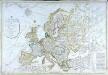
Europa recens descriptia. [Karte], in: Theatrum orbis terrarum, sive, Atlas novus, Bd. 1, S. 34.
1 Karte aus Atlas Blaeu, Joan Blaeu, Willem Janszoon
Europa recens descripta [Karte], in: Le théâtre du monde, ou, Nouvel atlas contenant les chartes et descriptions de tous les païs de la terre, Bd. 1, S. 36.
1 Karte aus Atlas Blaeu, Willem Janszoon und Blaeu, Joan Blaeu, Willem Janszoon

Dated events, World War map, by Stanley Turner
1 : 13000000 Turner, Stanley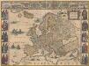
Europa recens descripta [Karte], in: Novus Atlas, das ist, Weltbeschreibung, Bd. 1, S. 22.
1 Karte aus Atlas Blaeu, Joan Blaeu, Willem Janszoon
Europa
E. von Sydow's Schul-Atlas in sechs und dreissig Karten Sydow, Emil von bei Justus Perthes
Geologie von Europa nach den Hauptverhältnissen
Erster Band, enthaltend in vier Abtheilungen die Erscheinungen der anorganischen Natur: 1. Meteorologie und Klimatographie. 2. Hydrologie und Hydrographie. 3. Geologie. 4. Tellurischer Magnetismus Humboldt, Alexander von Verlag von Justus Perthes
[Übersicht von Europa mit ethnograph. Begränzung der einzelnen Staaten, und den Völker-Sitzen in der Mitte des 19ten Jahrhunderts]
Zweiter Band, enthaltend in vier Abtheilungen die Vertheilung der Organismen: 5. Pflanzen-Geographie, 6. Thier-Geographie, 7. Anthropographie, 8. Ethnographie Humboldt, Alexander von Verlag von Justus Perthes
Europa
Schul-Atlas über alle Theile der Erde nach dem neuesten Zustande, und über das Weltgebäude Stieler, Adolf bei Justus Perthes
Karte von Europa
1 : 7500000 Berlin [etc.] : Ullstein
Europa
Atlas der Pflanzengeographie über alle Theile der Erde Rudolphi, Ludwig Verlag der Nicolaischen Buchhandlung
Europa
Hand-Atlas über alle Theile der Erde und über das Weltgebäude Stieler, Adolf Justus Perthes
Europa zur Uebersicht der Flussgebiete und Höhenzüge
Hand-Atlas über alle Theile der Erde nach dem neuesten Zustande und über das Weltgebäude Stieler, Adolf bei Justus Perthes
[Verbreitung und Vertheilung der Europäischen Vögel]
Zweiter Band, enthaltend in vier Abtheilungen die Vertheilung der Organismen: 5. Pflanzen-Geographie, 6. Thier-Geographie, 7. Anthropographie, 8. Ethnographie Humboldt, Alexander von Verlag von Justus Perthes
Europa mit politischer Begränzung der einzelnen Staaten
Hand-Atlas über alle Theile der Erde nach dem neuesten Zustande und über das Weltgebäude Stieler, Adolf bei Justus Perthes
Pas-kaart van Europa
1 Karte : Kupferdruck ; 42 x 53 cm Doncker by Hendrick Doncker inde Nieubrugsteegh
Letecká navigační mapa
Carte générale de l'Europe
1 Karte : Kupferdruck ; 52 x 76 cm Hérisson; Basset; Basset chez Basset rue Jacques au coin de celle des Mathurins no. 670
Europa
Schul-Atlas über alle Theile der Erde nach dem neuesten Zustande, und über das Weltgebäude Stieler, Adolf Justus Perthes
Europa. Bodengestalt
1 : 24000000 Europa Physische Geografie
Charte von Europa
1 Karte : Kupferdruck ; 43 x 54 cm Güssefeld bey den Homannis. Erben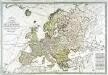
Carte générale de l'Europe
1 Karte auf 2 Blatt : Kupferdruck ; 51 x 75 cm Lotter; Lotter Lotter
[Recto], uit: Europa exactissime descripta / auctore Henrico Hondio
1 : 11500000 Annotatie: Uit: L'appendice de l'atlas de Gerard Mercator et Iudocus Hondius ... - Amsterdam : Henry Hondius, 1633; Met opdracht aan Lodewijk XIII Hondius, Henricus Amstelodami : sumptibus auctoris
Europe.
1 : 40000000 Levasseur, Victor.
Europa
E. von Sydow's Schul-Atlas in sechs und dreissig Karten Sydow, Emil von bei Justus Perthes
Europa
1 Karte : Kupferdruck ; 47 x 55 cm Walch Johann Walch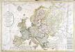
Carte générale de l'Europe
1 Karte : Kupferdruck ; 52 x 75 cm Hérisson; Basset; Basset chez Basset rue Jacques au coin de celle des Mathurins no. 670
Europa
Schul-Atlas in 36 Karten Völter, Daniel Verlag der J.M. Dannheimer'schen Buchhandlung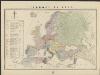
L'Europe en 1860
1 : 7800000 London : Edward Stanford
![Europa recens descriptia. [Karte], in: Theatrum orbis terrarum, sive, Atlas novus, Bd. 1, S. 34.](https://images-2.georeferencer.com/images/iiif/366381094984/full/,300/0/native.jpg)

