Maps of Europe

Europa
Schul-Atlas über alle Theile der Erde nach dem neuesten Zustande, und über das Weltgebäude Stieler, Adolf Justus Perthes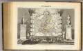
Europe.
1 : 40000000 Levasseur, Victor.
Europa mit politischer Begränzung der einzelnen Staaten
Hand-Atlas über alle Theile der Erde nach dem neuesten Zustande und über das Weltgebäude Stieler, Adolf bei Justus Perthes
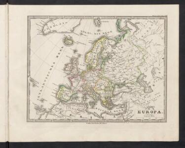
Europa
Schul-Atlas über alle Theile der Erde nach dem neuesten Zustande, und über das Weltgebäude Stieler, Adolf bei Justus Perthes
Europa mit politischer Begränzung der einzelnen Staaten
Hand-Atlas über alle Theile der Erde nach dem neuesten Zustande und über das Weltgebäude Stieler, Adolf bei Justus Perthes
[Übersicht von Europa mit ethnograph. Begränzung der einzelnen Staaten, und den Völker-Sitzen in der Mitte des 19ten Jahrhunderts]
Zweiter Band, enthaltend in vier Abtheilungen die Vertheilung der Organismen: 5. Pflanzen-Geographie, 6. Thier-Geographie, 7. Anthropographie, 8. Ethnographie Humboldt, Alexander von Verlag von Justus Perthes
Dated events, World War map, by Stanley Turner
1 : 13000000 Turner, Stanley
Europa
E. von Sydow's Schul-Atlas in sechs und dreissig Karten Sydow, Emil von bei Justus Perthes
Europa
E. von Sydow's Schul-Atlas in sechs und dreissig Karten Sydow, Emil von bei Justus Perthes
Europa
Atlas der Pflanzengeographie über alle Theile der Erde Rudolphi, Ludwig Verlag der Nicolaischen Buchhandlung
Europa
1 Karte : Kupferdruck ; 47 x 55 cm Walch Johann Walch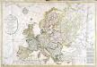
Carte générale de l'Europe
1 Karte : Kupferdruck ; 52 x 75 cm Hérisson; Basset; Basset chez Basset rue Jacques au coin de celle des Mathurins no. 670
[Verbreitung und Vertheilung der Europäischen Vögel]
Zweiter Band, enthaltend in vier Abtheilungen die Vertheilung der Organismen: 5. Pflanzen-Geographie, 6. Thier-Geographie, 7. Anthropographie, 8. Ethnographie Humboldt, Alexander von Verlag von Justus Perthes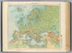
11-12. Europa fisica.
1 : 12000000 Touring club italiano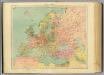
13-14. Europa politica.
1 : 12000000 Touring club italiano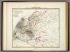
Karte von Europa.
1 : 13500000 Berghaus, Heinrich
Europa recens descripta [Karte], in: Le théâtre du monde, ou, Nouvel atlas contenant les chartes et descriptions de tous les païs de la terre, Bd. 1, S. 36.
1 Karte aus Atlas Blaeu, Willem Janszoon und Blaeu, Joan Blaeu, Willem Janszoon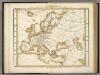
Karte Von Europa.
1 : 14500000 Berghaus, Heinrich
Handelskaart van Europa : ten dienste van het onderwijs / door J.J. ten Have
1 : 3333000 Annotatie: Met handelsprodukten en belangrijke handelsroutes J.J. ten Have 's-Gravenhage : Ykema
Verbreitung Der Wichtigsten Kultur, - Baum - Und Strauchgewachse In Europa.
1 : 15000000 Berghaus, Heinrich
Europa zur Uebersicht der Flussgebiete und Höhenzüge
Hand-Atlas über alle Theile der Erde nach dem neuesten Zustande und über das Weltgebäude Stieler, Adolf bei Justus Perthes
Europa
1 Karte : Kupferdruck ; 47 x 55 cm Walch Johann Walch
Europa
1 Karte : Kupferdruck ; 21 x 26 cm Reilly Franz J. J. von Reilly
Europe.
1 : 24000000 Darton, William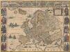
Europa recens descripta [Karte], in: Novus Atlas, das ist, Weltbeschreibung, Bd. 1, S. 22.
1 Karte aus Atlas Blaeu, Joan Blaeu, Willem Janszoon
Verbreitung und Vertheilung der Europaischen Vogel.
1 : 20000000 Berghaus, Heinrich
Charte von Europa
1 Karte : Kupferdruck ; 38 x 47 cm Güssefeld zu finden bey C. Weigel u. Schneider
Evropa
1 Karte : Kupferdruck ; 38 x 46 cm Mercator; Mercator; Hondius Henricus Hondius
Evropa
1 Karte : Kupferdruck ; 38 x 46 cm Mercator; Mercator; Hondius Henricus Hondius?