Maps of Europe
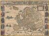
Europa recens descripta [Karte], in: Novus Atlas, das ist, Weltbeschreibung, Bd. 1, S. 22.
1 Karte aus Atlas Blaeu, Joan Blaeu, Willem Janszoon
Europa recens descripta [Karte], in: Le théâtre du monde, ou, Nouvel atlas contenant les chartes et descriptions de tous les païs de la terre, Bd. 1, S. 36.
1 Karte aus Atlas Blaeu, Willem Janszoon und Blaeu, Joan Blaeu, Willem Janszoon
Europa
Atlas der Pflanzengeographie über alle Theile der Erde Rudolphi, Ludwig Verlag der Nicolaischen Buchhandlung
Europa
E. von Sydow's Schul-Atlas in sechs und dreissig Karten Sydow, Emil von bei Justus Perthes

Europa recens descriptia. [Karte], in: Theatrum orbis terrarum, sive, Atlas novus, Bd. 1, S. 34.
1 Karte aus Atlas Blaeu, Joan Blaeu, Willem Janszoon
Europa
Schul-Atlas über alle Theile der Erde nach dem neuesten Zustande, und über das Weltgebäude Stieler, Adolf bei Justus Perthes
Europa mit politischer Begränzung der einzelnen Staaten
Hand-Atlas über alle Theile der Erde nach dem neuesten Zustande und über das Weltgebäude Stieler, Adolf bei Justus Perthes
[Recto], uit: Europa exactissime descripta / auctore Henrico Hondio
1 : 11500000 Annotatie: Uit: L'appendice de l'atlas de Gerard Mercator et Iudocus Hondius ... - Amsterdam : Henry Hondius, 1633; Met opdracht aan Lodewijk XIII Hondius, Henricus Amstelodami : sumptibus auctoris
Dated events, World War map, by Stanley Turner
1 : 13000000 Turner, Stanley
[Übersicht von Europa mit ethnograph. Begränzung der einzelnen Staaten, und den Völker-Sitzen in der Mitte des 19ten Jahrhunderts]
Zweiter Band, enthaltend in vier Abtheilungen die Vertheilung der Organismen: 5. Pflanzen-Geographie, 6. Thier-Geographie, 7. Anthropographie, 8. Ethnographie Humboldt, Alexander von Verlag von Justus Perthes
Charte von Europa
1 Karte : Kupferdruck ; 43 x 54 cm Güssefeld bey den Homannis. Erben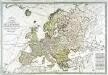
Carte générale de l'Europe
1 Karte auf 2 Blatt : Kupferdruck ; 51 x 75 cm Lotter; Lotter Lotter
Hyetographic or Rain Map of Europe
The physical atlas Johnston, Alexander Keith William Blackwood & Sons
Europa
Schul-Atlas über alle Theile der Erde nach dem neuesten Zustande, und über das Weltgebäude Stieler, Adolf Justus Perthes
General Karte von Europa
1 Karte : Kupferdruck ; 50 x 58 cm von der kön. privileg: Schneider und Weigelschen Kunst und Buchhandlung
L'Europe dans son etat actuel
1 Karte : Kupferdruck ; 47 x 61 cm Hérisson; Desray; Glot; Picquet chez Desray libraire rue Hautefeuille no. 4, chez Picquet géog.he graveur du cab. topographique de S. M. l'empereur et roi et de S. M. le roi de Hollande quai Malaquais no. 15
Europa. Bodengestalt
1 : 24000000 Europa Physische Geografie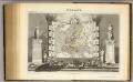
Europe.
1 : 40000000 Levasseur, Victor.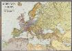
Karte von Europa
1 : 7500000 Berlin [etc.] : Ullstein
Europa
Hand-Atlas über alle Theile der Erde und über das Weltgebäude Stieler, Adolf Justus Perthes
Europe.
1 : 21542400 Lucas, Fielding Jr.
Geologie von Europa nach den Hauptverhältnissen
Erster Band, enthaltend in vier Abtheilungen die Erscheinungen der anorganischen Natur: 1. Meteorologie und Klimatographie. 2. Hydrologie und Hydrographie. 3. Geologie. 4. Tellurischer Magnetismus Humboldt, Alexander von Verlag von Justus Perthes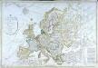
Carte générale de l'Europe
1 Karte : Kupferdruck ; 52 x 76 cm Hérisson; Basset; Basset chez Basset rue Jacques au coin de celle des Mathurins no. 670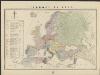
L'Europe en 1860
1 : 7800000 London : Edward Stanford
Europa zur Uebersicht der Flussgebiete und Höhenzüge
Hand-Atlas über alle Theile der Erde nach dem neuesten Zustande und über das Weltgebäude Stieler, Adolf bei Justus Perthes
Europa
E. von Sydow's Schul-Atlas in sechs und dreissig Karten Sydow, Emil von bei Justus Perthes
Europa ad magnae Europae Gerardi Mercatoris P. imitationem [...] [Karte], in: Atlas, sive, Cosmographicae meditationes de fabrica mundi et fabricati figura, S. 65.
1 Karte aus Atlas Mercator, Gerhard
Europa
Geographischer Atlas über alle Theile der Erde Ziegler, Jakob Melchior Verlag von Dietrich Reimer
![Europa recens descripta [Karte], in: Novus Atlas, das ist, Weltbeschreibung, Bd. 1, S. 22.](https://images-2.georeferencer.com/images/iiif/640508577453/full/,300/0/native.jpg)

