Maps of Europe

Letecká navigační mapa

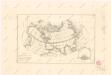
State of Nations at the Christian aera From Pinkerton on the Goths.
1 : 40000000 Finley, Anthony
Europe.
from New & accurate description of the earth in all its empires, kingdoms and states
Discoveries made by Captains Cook & Clerke.
1 : 43000000 Carey, Mathew
Map of the Discoveries made by Captn Cook & Clerke.
1 : 42000000 Carey, Mathew
Map of the Discoveries made by Capts. Cook & Clarke in the Years 1778 & 1779.
1 : 43000000 Carey, Mathew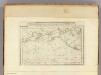
Map of the Discoveries made by Capts. Cook & Clerke.
1 : 43000000 Carey, Mathew
Map of the Discoveries made by Capts. Cook & Clerke.
1 : 43000000 Carey, Mathew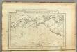
Map of the Discoveries made by Capts. Cook & Clerk.
1 : 30000000 Carey, Mathew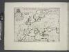
Europe.
from A new sett of maps both of antient and present geography : wherein not only the latitude and longitude of many places are corrected according to the latest observations, but also the most remarkable differences of antient and present geography may be quickly discern'd by a bare inspection or comparing of correspondent maps, which seems to be the most natural and easy method to lead young students (for whose use the work is principally intended) unto a competent knowledge of the geographical science : together with a geographical treatise particularly adapted to the use and design of these maps / by Edward Wells, M.A. and student of Christ-Church, Oxon.
E. Asia, W. North America.
1 : 41000000 Seaman, James V.
Carte des nouvelles decouvertes au nord de la mer du Sud
1 Karte : Kupferdruck ; 37 x 62 cm Santini; Remondini chez François Santini rue S.te Justine près de l'eglise, chez M. Remondini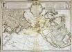
Carte des nouvelles découvertes au nord de la mer du Sud
1 Karte : Kupferdruck ; 37 x 62 cm Delisle; L'Isle; Buache s.n.
Carte de l'océan Pacifique au nord de l'equateur, et des côtes qui le bornent des deux côtés
1 Karte : Kupferdruck ; 36 x 50 cm Lotter publiée par Tobie Conrad Lotter
Map of Europe, showing its gt. political divisions.
from New general atlas.
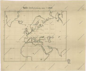
Ubersicht von Europa; mit ethnograph.
1 : 19008000 Berghaus, Heinrich
Nuove scoperte de'russi al nord del mare del Sud sí nell'Asia, che nell'America
1 Karte : Kupferdruck ; 30 x 39 cm Zatta presso Antonio Zatta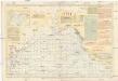
Pilot chart of the North Pacific Ocean
1 : 14300000 Tichý oceán (severní oblast) Maury, Matthew Fontaine Hydrographic Office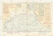
Pilot chart of the North Pacific Ocean
1 : 14300000 Tichý oceán (severní oblast) Maury, Matthew Fontaine Hydrographic Office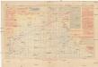
Pilot chart of the North Pacific Ocean
1 : 14300000 Tichý oceán (severní oblast) Maury, Matthew Fontaine Hydrographic Office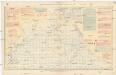
Pilot chart of the North Pacific Ocean
1 : 14300000 Tichý oceán (severní oblast) Maury, Matthew Fontaine Hydrographic Office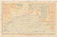
Pilot chart of the North Pacific Ocean
1 : 14300000 Tichý oceán (severní oblast) Maury, Matthew Fontaine Hydrographic Office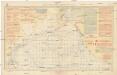
Pilot chart of the North Pacific Ocean
1 : 14300000 Tichý oceán (severní oblast) Maury, Matthew Fontaine Hydrographic Office
[Übersicht von Europa mit ethnograph. Begränzung der einzelnen Staaten, und den Völker-Sitzen in der Mitte des 19ten Jahrhunderts]
Zweiter Band, enthaltend in vier Abtheilungen die Vertheilung der Organismen: 5. Pflanzen-Geographie, 6. Thier-Geographie, 7. Anthropographie, 8. Ethnographie Humboldt, Alexander von Verlag von Justus Perthes
Dated events, World War map, by Stanley Turner
1 : 13000000 Turner, Stanley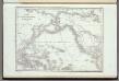
Carte De L'Ocean Pacifique Au Nord De L'Equateur.
1 : 54000000 Duflot de Mofras, Eugene
Europa zur Uebersicht der Flussgebiete und Höhenzüge
Hand-Atlas über alle Theile der Erde nach dem neuesten Zustande und über das Weltgebäude Stieler, Adolf bei Justus Perthes
Der noerdliche Theil des grossen Welt Meeres / von C. G. Reichard im Jahre 1804 ; Nach des Herrn von
1 : 11100000 1 Karte : Kupferdruck ; 49 x 67 cm Reichard, Christian Gottlieb Theophil im Verlage des Geograph. Instituts
Der noerdliche Theil des grossen Welt Meeres
1 Karte : Kupferdruck ; 48 x 65 cm Reichard im Verlage d. Industrie Comptoirs