Maps of Europe

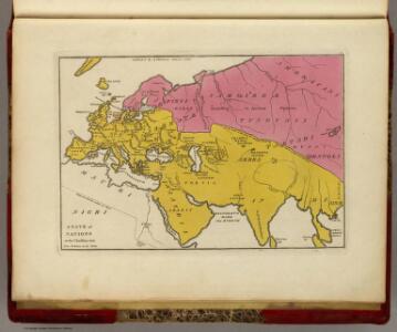
State of Nations at the Christian aera From Pinkerton on the Goths.
1 : 40000000 Finley, Anthony
E. Asia, W. North America.
1 : 41000000 Seaman, James V.
Discoveries made by Captains Cook & Clerke.
1 : 43000000 Carey, Mathew
Map of the Discoveries made by Captn Cook & Clerke.
1 : 42000000 Carey, Mathew
Map of the Discoveries made by Capts. Cook & Clarke in the Years 1778 & 1779.
1 : 43000000 Carey, Mathew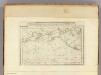
Map of the Discoveries made by Capts. Cook & Clerke.
1 : 43000000 Carey, Mathew
Map of the Discoveries made by Capts. Cook & Clerke.
1 : 43000000 Carey, Mathew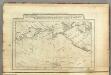
Map of the Discoveries made by Capts. Cook & Clerk.
1 : 30000000 Carey, Mathew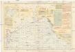
Pilot chart of the North Pacific Ocean
1 : 14300000 Tichý oceán (severní oblast) Maury, Matthew Fontaine Hydrographic Office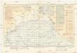
Pilot chart of the North Pacific Ocean
1 : 14300000 Tichý oceán (severní oblast) Maury, Matthew Fontaine Hydrographic Office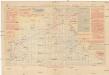
Pilot chart of the North Pacific Ocean
1 : 14300000 Tichý oceán (severní oblast) Maury, Matthew Fontaine Hydrographic Office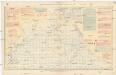
Pilot chart of the North Pacific Ocean
1 : 14300000 Tichý oceán (severní oblast) Maury, Matthew Fontaine Hydrographic Office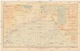
Pilot chart of the North Pacific Ocean
1 : 14300000 Tichý oceán (severní oblast) Maury, Matthew Fontaine Hydrographic Office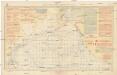
Pilot chart of the North Pacific Ocean
1 : 14300000 Tichý oceán (severní oblast) Maury, Matthew Fontaine Hydrographic Office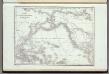
Carte De L'Ocean Pacifique Au Nord De L'Equateur.
1 : 54000000 Duflot de Mofras, Eugene
Map of Europe, showing its gt. political divisions.
from New general atlas.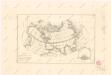
Calculus Eclipsis Solis Observatae die 19. Novemberis 1816
Arabia.
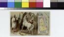
From [Series of advertising cards issued by Arbuckle Bros. Coffee Company, each consisting of a map of a country of the world with related illustrations.]
Letecká navigační mapa

Europe.
from New & accurate description of the earth in all its empires, kingdoms and states
Carte de l'océan Pacifique au nord de l'equateur, et des côtes qui le bornent des deux côtés
1 Karte : Kupferdruck ; 36 x 50 cm Lotter publiée par Tobie Conrad Lotter
Meteorological chart of the North Pacific Ocean
1 : 11000000 Tichý oceán (severní oblast) Secretary of Agriculture
Meteorological chart of the North Pacific Ocean
1 : 11000000 Tichý oceán (severní oblast) Secretary of Agriculture
Meteorological chart of the North Pacific Ocean
1 : 11000000 Tichý oceán (severní oblast) Secretary of Agriculture
Meteorological chart of the North Pacific Ocean
1 : 11000000 Tichý oceán (severní oblast) Secretary of Agriculture
Nuove scoperte de'russi al nord del mare del Sud sí nell'Asia, che nell'America
1 Karte : Kupferdruck ; 30 x 39 cm Zatta presso Antonio Zatta
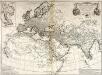
Terra Veteribus Nota.
1 : 47000000 Finley, Anthony
Der noerdliche Theil des grossen Welt Meeres
1 Karte : Kupferdruck ; 48 x 65 cm Reichard im Verlage d. Industrie Comptoirs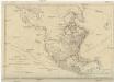
NORTH AMERICA, AS DIVIDED amongst THE EUROPEAN POWERS
Severní Amerika Dunn, Samuel