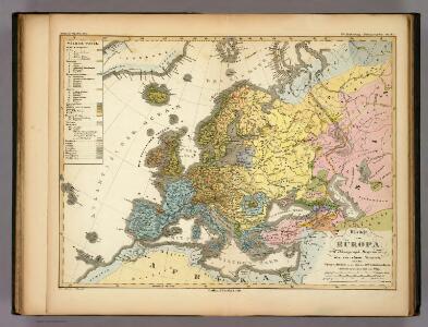
Maps of Europe

Ubersicht von Europa; mit ethnograph.
1 : 19008000 Berghaus, Heinrich
Moscovia.
from A new systeme of the mathematicks: containing I. Arithmetick, as well natural and decimal, as in species, or the principles of algebra. II. Practical geometry, together with the first six books of Euclid's Elements, as also the eleventh and twelfth, symbo
Letecká navigační mapa
Europe.
1 : 29000000 Moll, Herman, d. 1732
Nuove scoperte de'russi al nord del mare del Sud sí nell'Asia, che nell'America
1 Karte : Kupferdruck ; 30 x 39 cm Zatta presso Antonio Zatta
Nova Et Accurata Poli Arctici et terrarum Circum Iacentium Descriptio. [Karte], in: Novus atlas absolutissimus, Bd. 1, S. 22.
1 Karte aus Atlas Janssonius Offizin
Europa
1 Karte : Kupferdruck ; 47 x 55 cm Walch Johann Walch
Europa
1 Karte : Kupferdruck ; 21 x 26 cm Reilly Franz J. J. von Reilly
Cotes, l'Amerique, l'Asie.
1 : 25000000 La Perouse, Jean-Francois de Galaup, comte de, 1741-1788
[Übersicht von Europa mit ethnograph. Begränzung der einzelnen Staaten, und den Völker-Sitzen in der Mitte des 19ten Jahrhunderts]
Zweiter Band, enthaltend in vier Abtheilungen die Vertheilung der Organismen: 5. Pflanzen-Geographie, 6. Thier-Geographie, 7. Anthropographie, 8. Ethnographie Humboldt, Alexander von Verlag von Justus Perthes
Evropa
1 Karte : Kupferdruck ; 38 x 46 cm Mercator; Mercator; Hondius Henricus Hondius
Evropa
1 Karte : Kupferdruck ; 38 x 46 cm Mercator; Mercator; Hondius Henricus Hondius?
Evropa
1 Karte : Kupferdruck ; 38 x 46 cm Mercator; Mercator; Hondius Jodocus Hondius
Verbreitung und Vertheilung der Europaischen Vogel.
1 : 20000000 Berghaus, Heinrich
Carta etnográfica dell' Europa / dir. G.Marinelli ; Francesco Vallardi
1 : 20000000 G. Marinelli Francesco Vallardi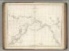
Chart of the Coasts of America and Asia.
1 : 19500000 La Perouse, Jean-Francois de Galaup, comte de, 1741-1788
Europa
E. von Sydow's Schul-Atlas in sechs und dreissig Karten Sydow, Emil von bei Justus Perthes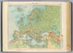
11-12. Europa fisica.
1 : 12000000 Touring club italiano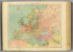
13-14. Europa politica.
1 : 12000000 Touring club italiano
Europa mit politischer Begränzung der einzelnen Staaten
Hand-Atlas über alle Theile der Erde nach dem neuesten Zustande und über das Weltgebäude Stieler, Adolf bei Justus Perthes
Europe.
1 : 20275200 Melish, John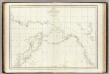
Cotes, l'Amerique, l'Asie.
1 : 25000000 La Perouse, Jean-Francois de Galaup, comte de, 1741-1788
Europa
Schul-Atlas über alle Theile der Erde nach dem neuesten Zustande, und über das Weltgebäude Stieler, Adolf bei Justus Perthes
Dated events, World War map, by Stanley Turner
1 : 13000000 Turner, Stanley
State of Nations at the Christian aera From Pinkerton on the Goths.
1 : 40000000 Finley, Anthony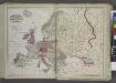
Europe
from New topographical atlas and gazetteer of New York, comprising a topographical view of the several counties of the state, ... including ... map of the United States and territories ... Compiled from the latest astronomical observations, official surveys and records of the United States and territories ...
Europa
1 : 30000 Evropa
Europa
1 Karte : Kupferdruck ; 47 x 55 cm Walch Johann Walch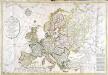
Carte générale de l'Europe
1 Karte : Kupferdruck ; 52 x 75 cm Hérisson; Basset; Basset chez Basset rue Jacques au coin de celle des Mathurins no. 670