Maps of Alaska
Cotes, l'Amerique, l'Asie.
1 : 25000000 La Perouse, Jean-Francois de Galaup, comte de, 1741-1788
Cotes, l'Amerique, l'Asie.
1 : 25000000 La Perouse, Jean-Francois de Galaup, comte de, 1741-1788
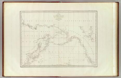
Chart of the Coasts of America and Asia.
1 : 19500000 La Perouse, Jean-Francois de Galaup, comte de, 1741-1788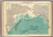
North Pacific Ocean.
1 : 25000000 John Bartholomew & Co.
Der noerdliche Theil des grossen Welt Meeres
1 Karte : Kupferdruck ; 48 x 65 cm Reichard im Verlage d. Industrie Comptoirs
Nova Et Accurata Poli Arctici et terrarum Circum Iacentium Descriptio. [Karte], in: Novus atlas absolutissimus, Bd. 1, S. 22.
1 Karte aus Atlas Janssonius Offizin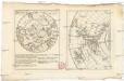
Neue Charte über die Durchfarth gegen Nord-Ost zwischen Asien und America samt den nahegelegenen Inslen [sic] und Ländern
Asie východní Marianus, Joseph
Der noerdliche Theil des grossen Welt Meeres / von C. G. Reichard im Jahre 1804 ; Nach des Herrn von
1 : 11100000 1 Karte : Kupferdruck ; 49 x 67 cm Reichard, Christian Gottlieb Theophil im Verlage des Geograph. Instituts
Regiones Sub Polo Arctico. [Karte], in: Le théâtre du monde, ou, Nouvel atlas contenant les chartes et descriptions de tous les païs de la terre, Bd. 1, S. 33.
1 Karte aus Atlas Blaeu, Willem Janszoon und Blaeu, Joan Blaeu, Willem Janszoon
Map of Europe, showing its gt. political divisions.
from New general atlas.
Mapa pozemků dvora Borek
1 : 4801
Carte de l'océan Pacifique au nord de l'equateur, et des côtes qui le bornent des deux côtés
1 Karte : Kupferdruck ; 36 x 50 cm Lotter publiée par Tobie Conrad Lotter
Tartariæ maioris sive Asiaticæ tabvla / ex recentissimis et probatissimis monumentis et relationib
1 : 17000000 1 Karte : Kupferdruck ; 46 x 53 cm Haas, Johann Matthias [Homännische Erben]
Imperii Russici et Tatariae universae tam majoris et asiaticae quam minoris et europaeae tabula / ex
1 : 17000000 1 Karte : Kupferdruck ; 46 x 53 cm Haas, Johann Matthias [Homännische Erben]
Etats de Moscovie / dediés a Monseig.nr le comte de Maurepas ministre et secretaire d'etat par son
1 : 17000000 1 Karte : Kupferdruck ; 46 x 53 cm Le Rouge, Georges-Louis [Le Rouge] rue des Augustins
Tartariae maioris sive Asiaticae tabula / ex recentissimis et probatissimis monumentis et relationib
1 : 17000000 1 Karte : Kupferdruck ; 46 x 53 cm Haas, Johann Matthias [Homännische Erben]
Imperii Russici et Tatariae universae tam majoris et asiaticæ quam minoris et europææ tabvla / ex
1 : 17000000 1 Karte : Kupferdruck ; 46 x 53 cm Haas, Johann Matthias Homännische Erben
Imperii Russici et Tatariae universae tam majoris et asiaticae quam minoris et europaeae tabula / ex
1 : 17000000 1 Karte : Kupferdruck ; 46 x 54 cm Haas, Johann Matthias [Homännische Erben]
E. Asia, W. North America.
1 : 41000000 Seaman, James V.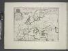
Europe.
from A new sett of maps both of antient and present geography : wherein not only the latitude and longitude of many places are corrected according to the latest observations, but also the most remarkable differences of antient and present geography may be quickly discern'd by a bare inspection or comparing of correspondent maps, which seems to be the most natural and easy method to lead young students (for whose use the work is principally intended) unto a competent knowledge of the geographical science : together with a geographical treatise particularly adapted to the use and design of these maps / by Edward Wells, M.A. and student of Christ-Church, Oxon.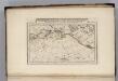
Discoveries made by Captains Cook & Clerke.
1 : 43000000 Carey, Mathew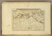
Map of the Discoveries made by Captn Cook & Clerke.
1 : 42000000 Carey, Mathew
Map of the Discoveries made by Capts. Cook & Clarke in the Years 1778 & 1779.
1 : 43000000 Carey, Mathew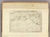
Map of the Discoveries made by Capts. Cook & Clerke.
1 : 43000000 Carey, Mathew
Map of the Discoveries made by Capts. Cook & Clerke.
1 : 43000000 Carey, Mathew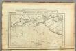
Map of the Discoveries made by Capts. Cook & Clerk.
1 : 30000000 Carey, Mathew
Nuove scoperte de'russi al nord del mare del Sud sí nell'Asia, che nell'America
1 Karte : Kupferdruck ; 30 x 39 cm Zatta presso Antonio Zatta
Moscovia.
from A new systeme of the mathematicks: containing I. Arithmetick, as well natural and decimal, as in species, or the principles of algebra. II. Practical geometry, together with the first six books of Euclid's Elements, as also the eleventh and twelfth, symbo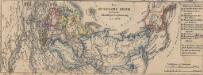
Das russische Reich nach seiner allmähligen Vergrösserung seit 1462
1 : 72000000 Russland / Asiatischer Teil