Maps of North America

Nova Et Accurata Poli Arctici et terrarum Circum Iacentium Descriptio. [Karte], in: Novus atlas absolutissimus, Bd. 1, S. 22.
1 Karte aus Atlas Janssonius Offizin
Regiones Sub Polo Arctico. [Karte], in: Le théâtre du monde, ou, Nouvel atlas contenant les chartes et descriptions de tous les païs de la terre, Bd. 1, S. 33.
1 Karte aus Atlas Blaeu, Willem Janszoon und Blaeu, Joan Blaeu, Willem Janszoon
Europe.
from A new sett of maps both of antient and present geography : wherein not only the latitude and longitude of many places are corrected according to the latest observations, but also the most remarkable differences of antient and present geography may be quickly discern'd by a bare inspection or comparing of correspondent maps, which seems to be the most natural and easy method to lead young students (for whose use the work is principally intended) unto a competent knowledge of the geographical science : together with a geographical treatise particularly adapted to the use and design of these maps / by Edward Wells, M.A. and student of Christ-Church, Oxon.
Tartariæ maioris sive Asiaticæ tabvla / ex recentissimis et probatissimis monumentis et relationib
1 : 17000000 1 Karte : Kupferdruck ; 46 x 53 cm Haas, Johann Matthias [Homännische Erben]
Imperii Russici et Tatariae universae tam majoris et asiaticae quam minoris et europaeae tabula / ex
1 : 17000000 1 Karte : Kupferdruck ; 46 x 53 cm Haas, Johann Matthias [Homännische Erben]
Etats de Moscovie / dediés a Monseig.nr le comte de Maurepas ministre et secretaire d'etat par son
1 : 17000000 1 Karte : Kupferdruck ; 46 x 53 cm Le Rouge, Georges-Louis [Le Rouge] rue des Augustins
Tartariae maioris sive Asiaticae tabula / ex recentissimis et probatissimis monumentis et relationib
1 : 17000000 1 Karte : Kupferdruck ; 46 x 53 cm Haas, Johann Matthias [Homännische Erben]
Imperii Russici et Tatariae universae tam majoris et asiaticæ quam minoris et europææ tabvla / ex
1 : 17000000 1 Karte : Kupferdruck ; 46 x 53 cm Haas, Johann Matthias Homännische Erben
Imperii Russici et Tatariae universae tam majoris et asiaticae quam minoris et europaeae tabula / ex
1 : 17000000 1 Karte : Kupferdruck ; 46 x 54 cm Haas, Johann Matthias [Homännische Erben]
North America.
1 : 20000000 Andree, Richard; Times (London, England)
Cotes, l'Amerique, l'Asie.
1 : 25000000 La Perouse, Jean-Francois de Galaup, comte de, 1741-1788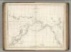
Chart of the Coasts of America and Asia.
1 : 19500000 La Perouse, Jean-Francois de Galaup, comte de, 1741-1788
[Ergänzungen und Berichtungen]
Geographischer Atlas über alle Theile der Erde Ziegler, Jakob Melchior Verlag von Dietrich Reimer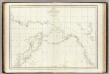
Cotes, l'Amerique, l'Asie.
1 : 25000000 La Perouse, Jean-Francois de Galaup, comte de, 1741-1788
Neue Charte über die Durchfarth gegen Nord-Ost zwischen Asien und America samt den nahegelegenen Inslen [sic] und Ländern
Asie východní Marianus, Joseph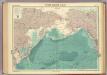
North Pacific Ocean.
1 : 25000000 John Bartholomew & Co.
Regiones Sub Polo Arctico. [Karte], in: Novus Atlas, das ist, Weltbeschreibung, Bd. 1, S. 19.
1 Karte aus Atlas Blaeu, Joan Blaeu, Willem Janszoon
Tartary.
1 : 23000000 Lucas, Fielding Jr.
Poli Arctici, Et Circumiacentium Terrarum Descriptio Novissima. [Karte], in: Gerardi Mercatoris et I. Hondii Newer Atlas, oder, Grosses Weltbuch, Bd. 1, S. 42.
1 Karte aus Atlas Mercator, Gerhard und Hondius, Jodocus Jansson, Jan
Ice Chart, Northern Hemisphere, October.
U.S. Navy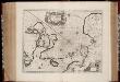
Nova et accvrata Poli Arctici et terrarum circum iacentium descriptio
1 : 17500000 Annotatie: Rechtsboven: IV; Origineel is Blad 148 in atlas factice Amstelodami : apud Ioannem Ianßonium
Ice Chart, Northern Hemisphere, April.
U.S. Navy
River Ice in Relation to Navigation, Average Annual Number of Days with Ice.
U.S. Navy
L'Asie 2.
1 : 9500000 Brue, Adrien Hubert, 1786-1832
Nova Et Accurata Poli Arctici et terrarum Circum Iacentium Descriptio. [Karte], in: Het vijfde Deel Des Grooten Atlas : Vervatende De Water-Weereld, S. 53.
1 Karte aus Atlas Jansson, Jan Jansson, Jan
Northern Asia, from the Himalaya Mountains to the Arctic Ocean.
1 : 10771200 Arrowsmith, John
Die allmaehlige Bildung des Russichen Reiches seit der MItte des XVten Jahrhundert's
1 : 40000000 Russland Expansion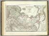
Russische Reich.
1 : 14300000 Weiland, C. F. (Carl Ferdinand), d. 1847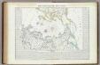
Carta generale del Polo Artico.
1 : 22500000 Marzolla, Benedetto
![Nova Et Accurata Poli Arctici et terrarum Circum Iacentium Descriptio. [Karte], in: Novus atlas absolutissimus, Bd. 1, S. 22.](https://images-2.georeferencer.com/images/iiif/179947209992/full/,300/0/native.jpg)

