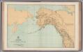
Maps of Alaska

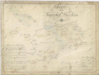
Mapa pozemků dvora Borek
1 : 4801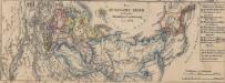
Das russische Reich nach seiner allmähligen Vergrösserung seit 1462
1 : 72000000 Russland / Asiatischer Teil
Der noerdliche Theil des grossen Welt Meeres
1 Karte : Kupferdruck ; 48 x 65 cm Reichard im Verlage d. Industrie Comptoirs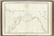
Cotes, l'Amerique, l'Asie.
1 : 25000000 La Perouse, Jean-Francois de Galaup, comte de, 1741-1788
Map of Europe, showing its gt. political divisions.
from New general atlas.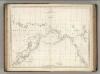
Chart of the Coasts of America and Asia.
1 : 19500000 La Perouse, Jean-Francois de Galaup, comte de, 1741-1788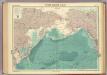
North Pacific Ocean.
1 : 25000000 John Bartholomew & Co.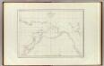
Cotes, l'Amerique, l'Asie.
1 : 25000000 La Perouse, Jean-Francois de Galaup, comte de, 1741-1788
Die allmaehlige Bildung des Russichen Reiches seit der MItte des XVten Jahrhundert's
1 : 40000000 Russland Expansion
Mappa geographica regni Bohemiae in duodecim circulos divisae ...
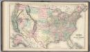
United States.
1 : 7240000 Gray, Ormando Willis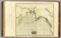
Northern Passage.
1 : 18000000 Thomson, John
Facsimile: Spanish Admiralty World in Mercator (portion).
1 : 15200000 Alaskan Boundary Tribunal
Der noerdliche Theil des grossen Welt Meeres / von C. G. Reichard im Jahre 1804 ; Nach des Herrn von
1 : 11100000 1 Karte : Kupferdruck ; 49 x 67 cm Reichard, Christian Gottlieb Theophil im Verlage des Geograph. Instituts
E. Asia, W. North America.
1 : 41000000 Seaman, James V.
Carte marine entre Californie et une partie de l'Asie la plus orientale
1 Karte : Kupferdruck ; 41 x 48 cm Königliche Akademie der Wissenschaften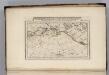
Discoveries made by Captains Cook & Clerke.
1 : 43000000 Carey, Mathew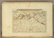
Map of the Discoveries made by Captn Cook & Clerke.
1 : 42000000 Carey, Mathew
Map of the Discoveries made by Capts. Cook & Clarke in the Years 1778 & 1779.
1 : 43000000 Carey, Mathew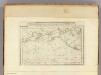
Map of the Discoveries made by Capts. Cook & Clerke.
1 : 43000000 Carey, Mathew
Map of the Discoveries made by Capts. Cook & Clerke.
1 : 43000000 Carey, Mathew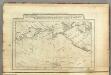
Map of the Discoveries made by Capts. Cook & Clerk.
1 : 30000000 Carey, Mathew
Nuove scoperte de'russi al nord del mare del Sud sí nell'Asia, che nell'America
1 Karte : Kupferdruck ; 30 x 39 cm Zatta presso Antonio Zatta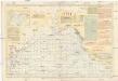
Pilot chart of the North Pacific Ocean
1 : 14300000 Tichý oceán (severní oblast) Maury, Matthew Fontaine Hydrographic Office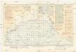
Pilot chart of the North Pacific Ocean
1 : 14300000 Tichý oceán (severní oblast) Maury, Matthew Fontaine Hydrographic Office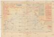
Pilot chart of the North Pacific Ocean
1 : 14300000 Tichý oceán (severní oblast) Maury, Matthew Fontaine Hydrographic Office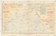
Pilot chart of the North Pacific Ocean
1 : 14300000 Tichý oceán (severní oblast) Maury, Matthew Fontaine Hydrographic Office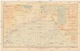
Pilot chart of the North Pacific Ocean
1 : 14300000 Tichý oceán (severní oblast) Maury, Matthew Fontaine Hydrographic Office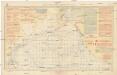
Pilot chart of the North Pacific Ocean
1 : 14300000 Tichý oceán (severní oblast) Maury, Matthew Fontaine Hydrographic Office