Maps of Czech Republic
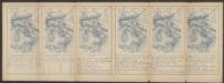
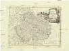
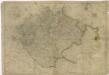
Bohemia Nova Descriptio Tabula XVII. [Karte], in: Claud. Ptolemaeus. Geographia lat. cum mappis [...], S. 407.
1 Karte aus Atlas Münster, Sebastian [und Ptolemaeus, Claudius]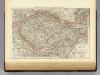
Bohemia, Moravia, Austrian Silesia.
1 : 1500000 Andree, Richard; Times (London, England)
[Böhmen, Mähren, Herzth Schleisien, Prov: Schlesien, Königr: Sachsen]
Schul-Atlas in 36 Karten Völter, Daniel Verlag der J.M. Dannheimer'schen Buchhandlung
Bojíště [sic]
Evropa střední Farský
Böhmisch-mährisches Stufenland
Tschechische Republik
La Boheme
1 : 1600000 Česko Slaart, Pieter van der Pierre Vander
Karten - Skizzen für die Schul - Praxis

Mezinárodní světová mapa: Praha
Das Königreich Böhmen
Přehledná mapa meteorologických stanic v Čechách, na Moravě a ve Slezsku
Regno di Boemia, ducato di Silesia, e marchesati di Moravia, e Lusazia
1 : 1800000 Lužice (Německo) Pitteri, Marco Alvise Antonio Zatta
Železniční a národopisná mapa zemí koruny české a rakouska-uherska s vyznačením hranic dicésáních a obvodů obchodních komor
Karte mehrer Eisenbahnen Oesterreichs & Deutschlands
Německo jižní
Geologische Übersichtskarte des Österreichischen Monarchie
1 : 576000 Rakousko-Uhersko Hauer, Franz Beck'schen Universitäts Buchhandlung (A. Hölder)
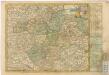
Östliches Deutschland oder Böhmen, Mähren und Schlesien
Hand-Atlas über alle Theile der Erde und über das Weltgebäude Stieler, Adolf Justus Perthes
Říše česká za knížete Boleslava II. okolo r. 973
1 : 2600000 Česko Kalousek, Josef Brož, Josef nákladem Františka Řivnáče

Östliches Deutschland sowie Böhmen, Mähren und Oesterreichisch Schlesien
Handatlas über alle Theile der Erde und über das Weltgebäude Stieler, Adolf Justus Perthes
Géographie. croquis n5, Bohême et Moravie
1 : 1000000 Molard, Jules, Commandant [Paris] : Service Géographique de l'Armée
České království
1 : 720000
La Boheme

Nieuwe kaart van t koninkryk Bohemen, thertogdom Silesien, markgraafschap Moravien en Lusatien
1 : 1750000 Lužice (Německo) Tirion, Isaac
Nieuwe kaart van t koninkryk Bohemen, thertogdom Silesien, markgraafschap Moravien en Lusatien
1 : 1750000 Lužice (Německo) Tirion, Isaac
Mittel-Östliches Deutschland oder Böhmen, Mähren und Schlesien
Hand-Atlas über alle Theile der Erde nach dem neuesten Zustande und über das Weltgebäude Stieler, Adolf bei Justus Perthes
[Mittel-Östliches Deutschland]
Hand-Atlas über alle Theile der Erde nach dem neuesten Zustande und über das Weltgebäude Stieler, Adolf bei Justus Perthes
Mittel-Östliches Deutschland oder Böhmen, Mähren und Schlesien
Stieler's Hand-Atlas Stieler, Adolf bei Justus Perthes
Carte internationale du monde au 1.000,000e
1 : 1000000 Česko Voj. zeměpisný ústav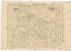
Poštovní mapa korunních zemí Čechy, Morava Slezsko
Česko Rašín, Jan náklad Farského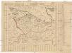
Poštovní mapa korunních zemí Čechy, Morava Slezsko
Česko Rašín, Jan náklad Farského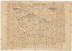
![Bohemia Nova Descriptio Tabula XVII. [Karte], in: Claud. Ptolemaeus. Geographia lat. cum mappis [...], S. 407.](https://images-2.georeferencer.com/images/iiif/250090260481/full/,300/0/native.jpg)

