Maps of Czech Republic

Mezinárodní světová mapa: Praha

Carte internationale du monde au 1.000,000e
1 : 1000000 Česko Voj. zeměpisný ústav
La Boheme
1 : 1600000 Česko Slaart, Pieter van der Pierre Vander
[Böhmen, Mähren, Herzth Schleisien, Prov: Schlesien, Königr: Sachsen]
Schul-Atlas in 36 Karten Völter, Daniel Verlag der J.M. Dannheimer'schen Buchhandlung
La Boheme
Bohemia Nova Descriptio Tabula XVII. [Karte], in: Claud. Ptolemaeus. Geographia lat. cum mappis [...], S. 407.
1 Karte aus Atlas Münster, Sebastian [und Ptolemaeus, Claudius]
Nieuwe kaart van t koninkryk Bohemen, thertogdom Silesien, markgraafschap Moravien en Lusatien
1 : 1750000 Lužice (Německo) Tirion, Isaac
Nieuwe kaart van t koninkryk Bohemen, thertogdom Silesien, markgraafschap Moravien en Lusatien
1 : 1750000 Lužice (Německo) Tirion, Isaac
Nova mappa geographica regni Bohemiae,] duc. [Silesiae marchi. Moraviae, march. Austriae] et Lusatiae ecaet.
1 : 350000 Mollova mapová sbírka Rizzi Zannoni, Giovanni Antonio Probst, Johann Michael
Karten - Skizzen für die Schul - Praxis

Ostdeutsches Mittelgebirge
Plastischer Schul-Atlas über alle Theile der Erde : in 24 Karten Woldermann, G Verlag von P. Eckerlein
The routs of the Prussian armies into Bohemia with the post roads and distances
1 : 2200000 Evropa střední Jefferys, Thomas T. Jefferys
Bohemia Silesia Moravia et Lvsatia
1 : 6900000 Mollova mapová sbírka Franz, Johann Michael Homann, Johann Baptista - dědici
Mittel-östliches Deutschland oder Böhmen, Mähren und Schlesien etc
1 : 1850000 Slezsko Stieler, Adolf Ausfeld, Johann Carl
Bohemia, Moravia, Austrian Silesia.
1 : 1500000 Andree, Richard; Times (London, England)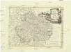
Regno di Boemia, ducato di Silesia, e marchesati di Moravia, e Lusazia
1 : 1800000 Lužice (Německo) Pitteri, Marco Alvise Antonio Zatta
Bojíště [sic]
Evropa střední Farský
Östliches Deutschland oder Böhmen, Mähren und Schlesien
Hand-Atlas über alle Theile der Erde und über das Weltgebäude Stieler, Adolf Justus Perthes
Belli ab obitu Caroli VI. Imperatoris usqve ad pacem Dresdae d. 25. Dec. MDCCXLV :
1 : 1300000 Mollova mapová sbírka Kraus, Lorenz Jacob Homann, Johann Baptista - dědici
[Mittel-Östliches Deutschland]
Hand-Atlas über alle Theile der Erde nach dem neuesten Zustande und über das Weltgebäude Stieler, Adolf bei Justus Perthes
Mittel-Östliches Deutschland oder Böhmen, Mähren und Schlesien
Stieler's Hand-Atlas Stieler, Adolf bei Justus Perthes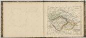

Böhmisch-mährisches Stufenland
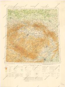
Tschechische Republik

Mappa geographica regnum Bohemiae cum adiunctis ducatu Silesiae et marchionatib[us] Moraviae et Lusatiae repraesentans
1 : 970000 Lužice (Německo) Lotter, Tobias Conrad Tob. Conr. Lotter
Mappa geographica regnum Bohemiae cum adiunctis ducatu Silesiae et marchionatib[us] Moraviae et Lusatiae repraesentans
1 : 970000 Lužice (Německo) Lotter, Tobias Conrad Tob. Conr. Lotter
Östliches Deutschland sowie Böhmen, Mähren und Oesterreichisch Schlesien
Handatlas über alle Theile der Erde und über das Weltgebäude Stieler, Adolf Justus Perthes
Charta Cursum Publicorum per Bohemiam, Silesiam, Moraviam, Lusatiam et Glacium
1 : 1300000 Kladsko-oblast (Polsko) Reilly, Franz Johann Josef von Müller, Franz Franz Johann Josef von Reilly
Le royaume de Boheme duché de Silesie, les marquisat de Moravie et de Lusace
1 : 1100000 Lužice (Německo) Sanson, Nicolas Schenk, Pieter Pierre Schenk