Maps of Czech Republic

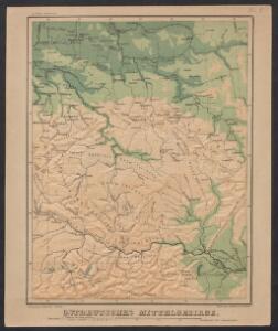
Ostdeutsches Mittelgebirge
Plastischer Schul-Atlas über alle Theile der Erde : in 24 Karten Woldermann, G Verlag von P. Eckerlein
Belli ab obitu Caroli VI. Imperatoris usqve ad pacem Dresdae d. 25. Dec. MDCCXLV :
1 : 1300000 Mollova mapová sbírka Kraus, Lorenz Jacob Homann, Johann Baptista - dědici
La Boheme, la Silesie.
1 : 3800000 Clouet, J. B. L. (Jean-Baptiste Louis), b. 1730
Nova mappa geographica regni Bohemiae,] duc. [Silesiae marchi. Moraviae, march. Austriae] et Lusatiae ecaet.
1 : 350000 Mollova mapová sbírka Rizzi Zannoni, Giovanni Antonio Probst, Johann Michael
Bez titulu: Čechy

Sbírka map a diagramů použitých na mírových konferencích v Paříži v letech 1919 - 1920

Historická mapa zemí Koruny České od XV. stol. a dnešní Slovensko

Politické rozdělení Československé republiky
Vojenský zeměpisný ústav
The routs of the Prussian armies into Bohemia with the post roads and distances
1 : 2200000 Evropa střední Jefferys, Thomas T. Jefferys
Nieuwe kaart van t koninkryk Bohemen, thertogdom Silesien, markgraafschap Moravien en Lusatien
1 : 1750000 Lužice (Německo) Tirion, Isaac
Nieuwe kaart van t koninkryk Bohemen, thertogdom Silesien, markgraafschap Moravien en Lusatien
1 : 1750000 Lužice (Německo) Tirion, Isaac
Böhmisch-mährisches Stufenland
Tschechische Republik
Regno di Boemia, ducato di Silesia, e marchesati di Moravia, e Lusazia
1 : 1800000 Lužice (Německo) Pitteri, Marco Alvise Antonio Zatta
Bojiště válek husitských v letech 1419-1434 : do bitvy u Lipan 30. května 1434
1 : 1500000 Evropa střední Kuffner, Hanuš Wagner, Jan Eduard R. Prombergr
Posádky v Zemích koruny české a v zemích zahraničních
1 : 1500000 Evropa střední Kuffner, Hanuš Wagner, Jan Eduard nákladem R. Prombergra
Mittel-Östliches Deutschland oder Böhmen, Mähren und Schlesien
Hand-Atlas über alle Theile der Erde nach dem neuesten Zustande und über das Weltgebäude Stieler, Adolf bei Justus Perthes
Regni Bohemiae Duc Silesiae Marchionatuum Moraviae et Lusatiae

Mappa geographica regnum Bohemiae cum adiunctis ducatu Silesiae et marchionatib[us] Moraviae et Lusatiae repraesentans
1 : 970000 Lužice (Německo) Lotter, Tobias Conrad Tob. Conr. Lotter
Mappa geographica regnum Bohemiae cum adiunctis ducatu Silesiae et marchionatib[us] Moraviae et Lusatiae repraesentans
1 : 970000 Lužice (Německo) Lotter, Tobias Conrad Tob. Conr. Lotter
Regni Bohemiae, Duc. Silesiae, Marchionatuum Moraviae et Lusatiae...

Bohemia Silesia Moravia et Lvsatia
1 : 6900000 Mollova mapová sbírka Franz, Johann Michael Homann, Johann Baptista - dědici
Mittel-östliches Deutschland oder Böhmen, Mähren und Schlesien etc
1 : 1850000 Slezsko Stieler, Adolf Ausfeld, Johann Carl
Karten - Skizzen für die Schul - Praxis

Bojíště [sic]
Evropa střední Farský
A map of Bohemia, Moravia, Silesia, Lussatia, with great part of Saxony & Brandenburg, shewing the present seat of war, in Germany
1 : 1970000 Braniborsko (Německo)
Mittel-Östliches Deutschland oder Böhmen, Mähren und Schlesien
Stieler's Hand-Atlas Stieler, Adolf bei Justus Perthes
Regnum Bohemia eique annexae provinciae ut ducatus Silesia marchionatus Moravia et Lusatia accuratissime delineata
1 : 1500000 Lužice (Německo) Kauffer, Michael Michael Kauffer iunior
Regni Bohemiae, Duc. Silesiae, Marchionatuum Moraviae et Lusatiae

Regni Bohemiae, dvc Silesiae, marchionatvvm Moraviae et Lvsatiae tabula generalis
1 : 987000 Česko Mayer, Tobias Müller, Johann Jacob Homann. Heredibus