Maps of Czech Republic
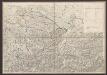
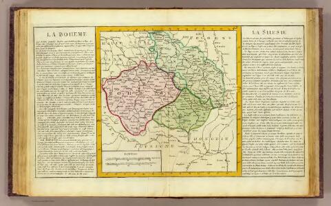
La Boheme, la Silesie.
1 : 3800000 Clouet, J. B. L. (Jean-Baptiste Louis), b. 1730
Historická mapa zemí Koruny České od XV. stol. a dnešní Slovensko

Bez titulu: Čechy

Sbírka map a diagramů použitých na mírových konferencích v Paříži v letech 1919 - 1920

Belli ab obitu Caroli VI. Imperatoris usqve ad pacem Dresdae d. 25. Dec. MDCCXLV :
1 : 1300000 Mollova mapová sbírka Kraus, Lorenz Jacob Homann, Johann Baptista - dědici
Mapa vsi Dědová s přilehlým vrchnostenských dvorem a lesem
1 : 3625
Il Regno di Boemia la Slesia Prussiana ed Austriaca noc li Marchesati di Muravia e Lusazia

A map of Bohemia, Moravia, Silesia, Lussatia, with great part of Saxony & Brandenburg, shewing the present seat of war, in Germany
1 : 1970000 Braniborsko (Německo)
Regni Bohemiae, Duc. Silesiae, Marchionatuum Moraviae et Lusatiae...

Ostdeutsches Mittelgebirge
Plastischer Schul-Atlas über alle Theile der Erde : in 24 Karten Woldermann, G Verlag von P. Eckerlein
Mittel-Östliches Deutschland oder Böhmen, Mähren und Schlesien
Hand-Atlas über alle Theile der Erde nach dem neuesten Zustande und über das Weltgebäude Stieler, Adolf bei Justus Perthes
Regnum Bohemiae...Ducatus Silesiae Marchionatus Moraviae et Lusatiae...

Mittel-östliches Deutschland oder Böhmen, Mähren und Schlesien etc
1 : 1850000 Slezsko Stieler, Adolf Ausfeld, Johann Carl
Mapa království českého
1 : 1000000
Mittel-Östliches Deutschland oder Böhmen, Mähren und Schlesien
Stieler's Hand-Atlas Stieler, Adolf bei Justus Perthes
[Mittel-Östliches Deutschland]
Hand-Atlas über alle Theile der Erde nach dem neuesten Zustande und über das Weltgebäude Stieler, Adolf bei Justus Perthes

Nova mappa geographica regni Bohemiae,] duc. [Silesiae marchi. Moraviae, march. Austriae] et Lusatiae ecaet.
1 : 350000 Mollova mapová sbírka Rizzi Zannoni, Giovanni Antonio Probst, Johann Michael
Karte des deuschen Krieggschauplatzes
Prusko Wiligut, Franz Karl Friedrich Beek
Östliches Deutschland sowie Böhmen, Mähren und Oesterreichisch Schlesien
Handatlas über alle Theile der Erde und über das Weltgebäude Stieler, Adolf Justus Perthes
Verkehrs - Karte von Böhmen, Mähren, Schlesien, Erzh. Oesterreich...

Regni Bohemiae Duc Silesiae Marchionatuum Moraviae et Lusatiae

Železniční a národopisná mapa zemí koruny české a rakouska-uherska s vyznačením hranic dicésáních a obvodů obchodních komor

Regni Bohemiae, Duc. Silesiae, Marchionatuum Moraviae et Lusatiae

Östliches Deutschland oder Böhmen, Mähren und Schlesien
Hand-Atlas über alle Theile der Erde und über das Weltgebäude Stieler, Adolf Justus Perthes
Germany. Deutschland IV. Austrian Dominions I.
1 : 1760000 Society for the Diffusion of Useful Knowledge (Great Britain)
Mapa království českého
1 : 1000000
Bez titulu: Rakouské dějiny