Maps of Metropolitan France

[Historisch-geographischer Atlas zu den allgemeinen Geschichtswerken von C. v. Rotteck, Pölitz u. Becker] : Deutschland und Frankreich während und nach der Reformation
von Julius Loewenberg Lithographie von B. Herder in Freiburg im Breisgau [Freiburg im Breisgau] : [Herder]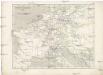
Napoleon's Kaiserreich im Jahre 1812
Evropa západní
[Historisch-geographischer Atlas zu den allgemeinen Geschichtswerken von C. v. Rotteck, Pölitz u. Becker] : Napoleon's Kaiserreich mit Angabe der Hauptbegebenheiten und der Vergrösserungen Frankreichs
von Julius Loewenberg Lithographie v. B. Herder in Freiburg im Breisgau [Freiburg im Breisgau] : [Herder]
Napoleon's Kaiserreich im Jahre 1812
Frankreich, Mitteleuropa, Napoleon I., Frankreich, Kaiser
Neueste Eisenbahn-Karte von Central-Europa
1 : 4000000 Evropa střední Issleib & Rietzschel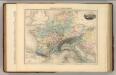
Empire de Charlemagne.
1 : 5000000 Migeon, J.
Die Republik und das Kaiserthum Frankreich mit seinen Bundes-Staaten.
1 : 5200000 Spruner von Merz, Karl
Die Reiche der Karolinger.
1 : 5300000 Spruner von Merz, Karl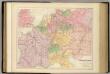
Central Europe with the Railways.
1 : 3168000 Fullarton, A. & Co.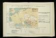
Izvoz robe i vrijednost produkcije većih tvornica 1912. Kralj. Hrvatska i Slavonija
Kroatien Slawonien Export Statistik Industrie
Gallia Germania Britannia
Schul-Atlas der alten Welt bei Justus Perthes

[Historisch-geographischer Atlas zu den allgemeinen Geschichtswerken von C. v. Rotteck, Pölitz u. Becker] : Das Reich Karls des Grossen nach der Theilung seiner Enkel zu Verdun 843
von Julius Loewenberg Lithographie von B. Herder in Freiburg im Breisgau [Freiburg im Breisgau] : [Herder]
Gallia, Britannia, Germania, Provinciae danuvienses.
1 : 5000000 Kiepert, Heinrich, 1818-1899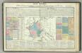
Tableau l'historie de France.
1 : 8250000 Duval, Henri
Die Zeit der ersten franz. Republik
Frankreich, Deutschland, Französische Revolution
Gallia et Germania ultimorum Romani Imperii temporum aequalis
1 : 4000000 Mollova mapová sbírka Liebe, Christian Sigismund
Rozšíření nejstarší keramiky české v Evropě
Evropa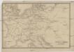
Übersichtskarte des Eisenbahn- und Telegraphen-Verbindungen von Mittel-Europa
1 : 6170000 Evropa střední Mayer, Alexander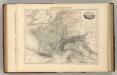
Empire Francais en 1811.
1 : 4840000 Migeon, J.
Carta delle strade ferrate dell'Europa centrale
1 : 2000000 Evropa střední Kirchmayr, C. Colombo Coen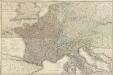
Carte géographique et administrative du Royaume de France comprenant en outre le Royaume des Pays-Bas, l'Allemagne, l'Empire d'Autriche, la Suisse, les Etats du Roi de Sardaigne sur le continent, les duchés de Parme et de Toscane, l'Etat de l'Eglise, l'Ile d'Elbe, les Sept-Iles Ioniennes en supplement et une partie de l'Empire Turc, des Royaumes de Prusse, de Naples, d'Angleterre, d'Espagne jusqu'à Madrid
1 : 1200000 dessinée par Hérisson Paris : chez Desray, J. Goujon
[Geschichtlich-geographischer Atlas von Europa :] X. Karte von Mittel-Europa mit der Provinzial-Eintheilung der verschiedenen Staaten
entworfen und gezeichnet durch Ferd. Aug. v. Witzleben [Berlin etc.] : [Mittler]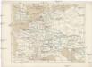
Gallia, Britannia, Rhaetia, Noricum, Pannonia, Germania
Galie
Die Reiche der Carolinger
1 : 8400000 Evropa západní
Die Verbreitung des Kropfes in Mittel-Europa
1 : 8000000 Bircher, Heinrich Benno Schwabe, Schweighauserische Verlagsbuchhandlung
France &c.
1 : 2400000 Brue, Adrien Hubert, 1786-1832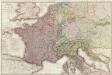
Composite: France.
1 : 1170000 Herisson, Eustache, b. 1759
Imperivm Francicvm vel Romanvm Occidentale Posterivs sub ipso Carolo Magno
1 : 28000000 Mollova mapová sbírka Homann, Johann Baptist Homann, Johann Baptista - dědici
![[Historisch-geographischer Atlas zu den allgemeinen Geschichtswerken von C. v. Rotteck, Pölitz u. Becker] : Deutschland und Frankreich während und nach der Reformation](https://images-1.georeferencer.com/images/iiif/802687665771/full/,300/0/native.jpg)

