Maps of Metropolitan France

[Geschichtlich-geographischer Atlas von Europa :] X. Karte von Mittel-Europa mit der Provinzial-Eintheilung der verschiedenen Staaten
entworfen und gezeichnet durch Ferd. Aug. v. Witzleben [Berlin etc.] : [Mittler]
Rozšíření nejstarší keramiky české v Evropě
Evropa
Gallia, Britannia, Germania, Provinciae danuvienses.
1 : 5000000 Kiepert, Heinrich, 1818-1899
Neueste Eisenbahn-Karte von Central-Europa
1 : 4000000 Evropa střední Issleib & Rietzschel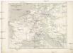
Napoleon's Kaiserreich im Jahre 1812
Evropa západní
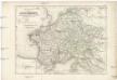
[Historisch-geographischer Atlas zu den allgemeinen Geschichtswerken von C. v. Rotteck, Pölitz u. Becker] : Gallien, Britannien, Germanien und die obern Donau-Länder nach Cæsar, Tacitus, Ptolemæus, Plinius, etc.
von Joh. Val. Kutscheit Lithographie der Herderschen Verlags-Handlung zu Freiburg im Breisg. [Freiburg im Breisgau] : [Herder]
Itineraire-Karte
1 : 6000000 Evropa
Die Reiche der Karolinger.
1 : 5300000 Spruner von Merz, Karl
Tableau l'historie de France.
1 : 8250000 Duval, Henri
Schul-Atlas für die alte Erdbeschreibung : zur allgemeinen Schul-encyclopädie gehörig
J. H. Campe Zusammensetzung und Zeichnung von [...] Dufour, unter Leitung von Heusinger ; gestochen von Frentzel. Braunschweig : Schulbuchhandlung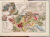
Geognost. Karte, Central- u. West-Europa.
1 : 4070000 Meyer, Joseph, 1796-1856
Gallia Germania Britannia
Schul-Atlas der alten Welt bei Justus Perthes
Kriegszusammenhänge IV (1740 - 1763)
1 : 15000000 Europa Österreichischer Erbfolgekrieg , Schlesische Kriege
Říše Karla Velikého
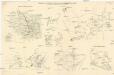
Skizzen zu den größeren Manövern der fremden Armeen 1906
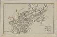
Francie Streffleur, Valentin Ritter von L. W. Seidel & Sohn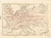
Eisenbahnkarte von Mitteleuropa
Die Reiche der Carolinger
1 : 8400000 Evropa západní
Gallia, Britannia, Rhaetia, Noricum, Pannonia, Germania
Galie
France, Switzerland, Germany.
Goodrich, S.G.
Germany.
from A new systeme of the mathematicks: containing I. Arithmetick, as well natural and decimal, as in species, or the principles of algebra. II. Practical geometry, together with the first six books of Euclid's Elements, as also the eleventh and twelfth, symbo
Gallia et Germania ultimorum Romani Imperii temporum aequalis
1 : 4000000 Mollova mapová sbírka Liebe, Christian Sigismund
[Historisch-geographischer Atlas zu den allgemeinen Geschichtswerken von C. v. Rotteck, Pölitz u. Becker] : Napoleon's Kaiserreich mit Angabe der Hauptbegebenheiten und der Vergrösserungen Frankreichs
von Julius Loewenberg Lithographie v. B. Herder in Freiburg im Breisgau [Freiburg im Breisgau] : [Herder]
Geognostische Übersichts-Karte von Deutschland, Frankreich, England und den angrenzenden Laendern
Francie Buch, Leopold von Dechen, Heinrich von bei Simon Schropp et Comp.
Die Republik und das Kaiserthum Frankreich mit seinen Bundes-Staaten.
1 : 5200000 Spruner von Merz, Karl
Stannard & Son's, panoramic birds-eye view of France & Prussia and the surrounding countries likely to be involved in the War, with the railways & startegic positions of each army, & the great fortresses of the Rhine provinces
1 : 1
Gran carta del teatro della guerra nel 1870
1 : 2340000 Evropa střední Stabilimento civelli

Die Zeit der ersten franz. Republik
Frankreich, Deutschland, Französische Revolution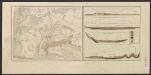
![[Geschichtlich-geographischer Atlas von Europa :] X. Karte von Mittel-Europa mit der Provinzial-Eintheilung der verschiedenen Staaten](https://images-2.georeferencer.com/images/iiif/626502273064/full/,300/0/native.jpg)

