Maps of Metropolitan France

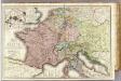
Imperivm Francicvm vel Romanvm Occidentale Posterivs sub ipso Carolo Magno
1 : 28000000 Mollova mapová sbírka Homann, Johann Baptist Homann, Johann Baptista - dědici
Tab. IV. Imperii Francici vel Romano German S. Romani Occid.
1 : 8500000 Mollova mapová sbírka Homann, Johann Baptist Homann, Johann Baptista - dědici
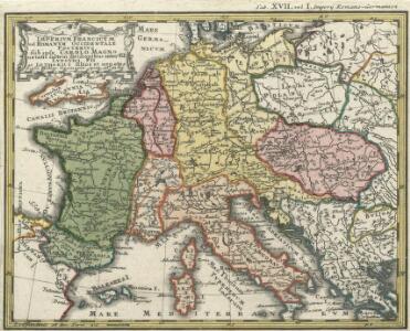
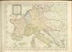
Tab. IV. Imperii Francici vel Romano-German. S. Romani Occid.
1 : 8500000 Mollova mapová sbírka Homann, Johann Baptist Homann, Johann Baptista - dědici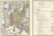
Tab. IV. Imperii Francici vel Romano-German. S. Romani Occid.
1 : 8500000 Mollova mapová sbírka Homann, Johann Baptist Homann, Johann Baptista - dědici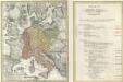
Tab. IV. Imperii Francici vel Romano-German. S. Romani Occid.
1 : 8500000 Mollova mapová sbírka Homann, Johann Baptist Homann, Johann Baptista - dědici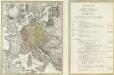
Tab. IV. Imperii Francici vel Romano-German. S. Romani Occid.
1 : 8500000 Mollova mapová sbírka Homann, Johann Baptist Homann, Johann Baptista - dědici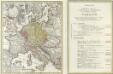
Tab. IV. Imperii Francici vel Romano-German. S. Romani Occid.
1 : 8500000 Mollova mapová sbírka Homann, Johann Baptist Homann, Johann Baptista - dědici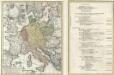
Tab. IV. Imperii Francici vel Romano-German. S. Romani Occid.
1 : 8500000 Mollova mapová sbírka Homann, Johann Baptist Homann, Johann Baptista - dědici
Říše Karla Velikého

West- u. Mittel- Europa im Zeitalter Napoleons (bis 1810)
Evropa střední F. Tempsky

[Europa's Haupt-Gebirgs-Systeme]
Erster Band, enthaltend in vier Abtheilungen die Erscheinungen der anorganischen Natur: 1. Meteorologie und Klimatographie. 2. Hydrologie und Hydrographie. 3. Geologie. 4. Tellurischer Magnetismus Humboldt, Alexander von Verlag von Justus Perthes
Napoleon's Kaiserreich im Jahre 1812
Frankreich, Mitteleuropa, Napoleon I., Frankreich, Kaiser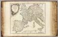
Imper. Caroli Magni.
1 : 5000000 Robert de Vaugondy, Gilles, 1688-1766
[Historisch-geographischer Atlas zu den allgemeinen Geschichtswerken von C. v. Rotteck, Pölitz u. Becker] : Napoleon's Kaiserreich mit Angabe der Hauptbegebenheiten und der Vergrösserungen Frankreichs
von Julius Loewenberg Lithographie v. B. Herder in Freiburg im Breisgau [Freiburg im Breisgau] : [Herder]
[Historisch-geographischer Atlas zu den allgemeinen Geschichtswerken von C. v. Rotteck, Pölitz u. Becker] : Das Reich Karls des Grossen nach der Theilung seiner Enkel zu Verdun 843
von Julius Loewenberg Lithographie von B. Herder in Freiburg im Breisgau [Freiburg im Breisgau] : [Herder]
Die Republik und das Kaiserthum Frankreich mit seinen Bundes-Staaten.
1 : 5200000 Spruner von Merz, Karl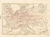
Eisenbahnkarte von Mitteleuropa

Gallia, Britannia, Germania, Provinciae danuvienses.
1 : 5000000 Kiepert, Heinrich, 1818-1899
Rozšíření nejstarší keramiky české v Evropě
Evropa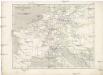
Napoleon's Kaiserreich im Jahre 1812
Evropa západní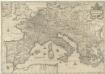
Imperium Caroli Magni
1 : 7400000 Mollova mapová sbírka Janssonius, Johannes Janssonius, Johannes I
Sbírka map a diagramů použitých na mírových konferencích v Paříži v letech 1919 - 1920

Kriegszusammenhänge IV (1740 - 1763)
1 : 15000000 Europa Österreichischer Erbfolgekrieg , Schlesische Kriege
32. Mitteleuropa nach dem Reichsdeputationshauptschluss im Jahre 1803
Mitteleuropa Reichsdeputationshauptschluss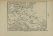
La Germanie à l’époque des invasions des Cimbres et des Teutons à travers l’Europe
Mitteleuropa Germanien Kimbern Teutonen Augustus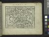
Germania.
from Abraham Ortelius his epitome of the theater of the worlde / nowe latlye ... renewed and augmented ... by Micheal Coignet, mathematitian of Antwarpe.
Neueste Eisenbahn-Karte von Central-Europa
1 : 4000000 Evropa střední Issleib & Rietzschel