Maps of Mediterranean Sea
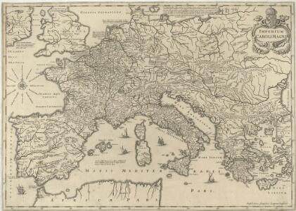
Imperium Caroli Magni
1 : 7400000 Mollova mapová sbírka Janssonius, Johannes Janssonius, Johannes I
Centraal-, West-, en Zuid-Europa
1 : 3700000 [S.l. : s.n.]
IMPERII | CAROLI MAGNI | et vicinarum regionum | DESCRIPTIO, | Dedicata et inscripta | LVDOVICO, | REGI, VICTORI, | ET DEFENSORI ECCLESIÆ | CHRISTI
ab Auctore Petro Bertio | ejusdem Cosmographo. [Amsterdam : Joan Blaeu]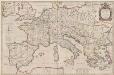
Imperii Caroli Magni et vicinarum regionum Descriptio [Karte], in: Theatrum orbis terrarum, sive, Atlas novus, Bd. 2, S. 167.
1 Karte aus Atlas Blaeu, Joan Blaeu, Willem Janszoon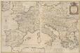
Imperii Caroli Magni et vicinarum regionum Descriptio [...] [Karte], in: Novus Atlas, das ist, Weltbeschreibung, Bd. 2, S. 165.
1 Karte aus Atlas Blaeu, Joan Blaeu, Willem Janszoon
[Historisch-geographischer Atlas zu den allgemeinen Geschichtswerken von C. v. Rotteck, Pölitz u. Becker] : Die Reiche im Süden Europa's im Anfange des achten Jahrhunderts
von Julius Loewenberg Lithographie von B. Herder in Freiburg im Breisg. [Freiburg im Breisgau] : [Herder]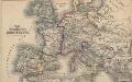
Das Zeitalter der Hohenstaufen
Mitteleuropa
Europa zur Zeit Napoleons
Europa Napoleon I., Frankreich, Kaiser
[Historisch-geographischer Atlas zu den allgemeinen Geschichtswerken von C. v. Rotteck, Pölitz u. Becker] : Das Weströmische Reich bis zu seinem Untergange unter Romulus Augustulus
von Julius Loewenberg Lithographie von B. Herder in Freiburg im Breisgau [Freiburg im Breisgau] : [Herder]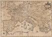
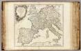
Imperium Caroli Magni [Karte], in: Novus atlas absolutissimus, Bd. 4, S. 28.
1 Karte aus Atlas Janssonius Offizin
Imperii Caroli Magni et vicinarum regionum Descriptio [Karte], in: Le théâtre du monde, ou, Nouvel atlas contenant les chartes et descriptions de tous les païs de la terre, Bd. 2, S. 165.
1 Karte aus Atlas Blaeu, Willem Janszoon und Blaeu, Joan Blaeu, Willem Janszoon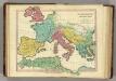
Patriarchati Occidentalis. (1826)
1 : 12100000 Tanner, Henry S.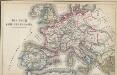
Das Reich Karl des Großen
Europa Karl I., Heiliges Römisches Reich, Kaiser
[Europa's Haupt-Gebirgs-Systeme]
Erster Band, enthaltend in vier Abtheilungen die Erscheinungen der anorganischen Natur: 1. Meteorologie und Klimatographie. 2. Hydrologie und Hydrographie. 3. Geologie. 4. Tellurischer Magnetismus Humboldt, Alexander von Verlag von Justus Perthes
Mittel- u. Westeuropa zur Zeit der größten Gebietsausdehnung des Napoleonischen Reichs
1 : 13700000 Westeuropa, Mitteleuropa, Napoleon I., Frankreich, Kaiser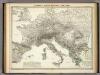
Europa's Haupt-Gebirgs Systeme.
1 : 6640000 Berghaus, Heinrich
[Personifizierte Europa als Königin mit Reichsapfel und Zepter, Hispania bildet den Kopf]
1 Karte : Holzschnitt ; 16 x 26 cm Münster, Sebastian [Sebastian Münster]
[Personifizierte Europa als Königin mit Reichsapfel und Zepter, Hispania bildet den Kopf]
1 Karte : Holzschnitt ; 16 x 26 cm Münster, Sebastian [Sebastian Münster]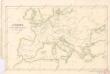
Evropa v době humdsko - germánské od 4. do 6. stol.

Carte Generale des Chemin de Fer Europeens.
1 : 3200000 Migeon, J.
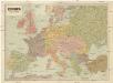
Europe
1 : 4000000 Evropa Andriveau-Goujon, E. E. Andriveau-Goujon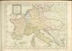
Západní a střední Evropa v době absolutismu až do konce francouzské revoluce
Imper. Caroli Magni.
1 : 5000000 Robert de Vaugondy, Gilles, 1688-1766
Cestovní spoje v Evropě
Evropa
Carte Routiere et Postale de la France

Europa im Zeitalter Napoleons
1 : 15000000 Europa Napoleon I., Frankreich, Kaiser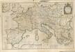
Evropa
1 : 5000000 Evropa V. Neubert