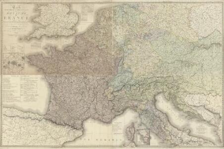
Maps of Metropolitan France
Carte géographique et administrative du Royaume de France comprenant en outre le Royaume des Pays-Bas, l'Allemagne, l'Empire d'Autriche, la Suisse, les Etats du Roi de Sardaigne sur le continent, les duchés de Parme et de Toscane, l'Etat de l'Eglise, l'Ile d'Elbe, les Sept-Iles Ioniennes en supplement et une partie de l'Empire Turc, des Royaumes de Prusse, de Naples, d'Angleterre, d'Espagne jusqu'à Madrid
1 : 1200000 dessinée par Hérisson Paris : chez Desray, J. Goujon
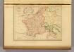
Composite: France.
1 : 1170000 Herisson, Eustache, b. 1759
[Historisch-geographischer Atlas zu den allgemeinen Geschichtswerken von C. v. Rotteck, Pölitz u. Becker] : Das Reich Karls des Grossen nach der Theilung seiner Enkel zu Verdun 843
von Julius Loewenberg Lithographie von B. Herder in Freiburg im Breisgau [Freiburg im Breisgau] : [Herder]
France &c.
1 : 2400000 Brue, Adrien Hubert, 1786-1832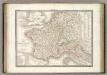
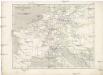
France 1789, 1813.
1 : 3700000 Lapie, M. (Pierre), 1779-1850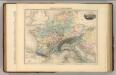
Empire de Charlemagne.
1 : 5000000 Migeon, J.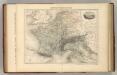
Empire Francais en 1811.
1 : 4840000 Migeon, J.

Die Republik und das Kaiserthum Frankreich mit seinen Bundes-Staaten.
1 : 5200000 Spruner von Merz, Karl
Die Zeit der ersten franz. Republik
Frankreich, Deutschland, Französische Revolution
Die Reiche der Karolinger.
1 : 5300000 Spruner von Merz, Karl
Itineraire-Karte
1 : 6000000 Evropa
Gallia Germania Britannia
Schul-Atlas der alten Welt bei Justus Perthes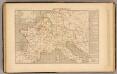
Demembrement de l'Empre. de Charlemagne.
1 : 5800000 Houze, Antoine Philippe

Tableau l'historie de France.
1 : 8250000 Duval, Henri
Kriegszusammenhänge IV (1740 - 1763)
1 : 15000000 Europa Österreichischer Erbfolgekrieg , Schlesische Kriege
Gallia et Germania ultimorum Romani Imperii temporum aequalis
1 : 4000000 Mollova mapová sbírka Liebe, Christian Sigismund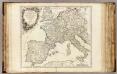
Imper. Caroli Magni.
1 : 5000000 Robert de Vaugondy, Gilles, 1688-1766
Říše Karla Velikého
Empire France et Royaume d"Italie, 1812.
1 : 6900000 Malte-Brun, Conrad, 1775-1826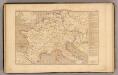
L'Empre. de Charlemagne de 768 a 814.
1 : 5800000 Houze, Antoine Philippe
[Historisch-geographischer Atlas zu den allgemeinen Geschichtswerken von C. v. Rotteck, Pölitz u. Becker] : Deutschland und Frankreich während und nach der Reformation
von Julius Loewenberg Lithographie von B. Herder in Freiburg im Breisgau [Freiburg im Breisgau] : [Herder]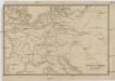
Übersichtskarte des Eisenbahn- und Telegraphen-Verbindungen von Mittel-Europa
1 : 6170000 Evropa střední Mayer, Alexander
Neueste Eisenbahn-Karte von Central-Europa
1 : 4000000 Evropa střední Issleib & Rietzschel
Napoleon's Kaiserreich im Jahre 1812
Frankreich, Mitteleuropa, Napoleon I., Frankreich, Kaiser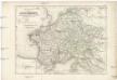
Die Reiche der Carolinger
1 : 8400000 Evropa západní
Západní Evropa při konci XIV. věku
Napoleon's Kaiserreich im Jahre 1812
Evropa západní