Maps of Studánka
Porostní mapa lesního hospodářského okresu A. Svatá, B. Studánka, C. Trnová
1 : 11493
Hospodářská mapa revíru Tachov-Studánka
1 : 5760
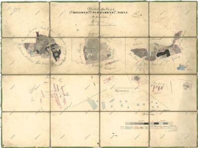
Katastrální mapa obce Studánky
1 : 2880
Schönbrunn - c7497-3-003 - Kaiserpflichtexemplar der Landkarten des stabilen Katasters
1 : 2880
Schönbrunn - c7497-3-001 - Kaiserpflichtexemplar der Landkarten des stabilen Katasters
1 : 2880
Schönbrunn - c7497-3-004 - Kaiserpflichtexemplar der Landkarten des stabilen Katasters
1 : 2880
Schönbrunn - c7497-3-002 - Kaiserpflichtexemplar der Landkarten des stabilen Katasters
1 : 2880
Albersdorf - c5777-1-004 - Kaiserpflichtexemplar der Landkarten des stabilen Katasters
1 : 2880
Albersdorf - c5777-1-002 - Kaiserpflichtexemplar der Landkarten des stabilen Katasters
1 : 2880
Albersdorf - c5777-1-003 - Kaiserpflichtexemplar der Landkarten des stabilen Katasters
1 : 2880
Albersdorf - c5777-1-001 - Kaiserpflichtexemplar der Landkarten des stabilen Katasters
1 : 2880
Katastrální mapa obce Studánky
1 : 2880
Přehledná mapa panství Planá
1 : 25000
[Kartenblatt]
1 : 25000 Halže (Česko) Reichsamt für Landesaufnahme
Lesní přehledová mapa velkostatku Tachov
1 : 20173

Bestandeskarte des Hauptcomplexes der Domaine Tachau
1 : 29000 Tachov-oblast (Česko) Anderlik, Otto Verlag des böhm. Forstvereins
Uibersichtskarte der Herrschaft Tachau
Tachov-oblast (Česko) Waraus, E. André Verlag des böhm. Forstvereins
Hayder Vicariat
Bor-oblast (Tachov, Česko)
Marienbad und Tachau
1 : 75000 Mariánské Lázně (Česko : oblast) Höller, K. K. u. k. Militärgeographisches Institut
Marienbad und Tachau
1 : 75000 Mariánské Lázně (Česko : oblast) K. u. k. Militärgeographisches Institut
Přehledová mapa velkostatku Tachov
1 : 17280
Mariánské Lázně
1 : 75000 Chodová Planá (Česko : oblast) Vojenský zeměpisný ústav
Mariánské Lázně
1 : 75000 Mariánské Lázně (Česko : oblast) Vojenský zeměpisný ústav
Mariánské Lázně
1 : 75000 Mariánské Lázně-oblast (Česko) Vojenský zeměpisný ústav
III. vojenské mapování 4049
1 : 75000
Politický okres Tachov
1 : 75000 Tachov (Česko : okres : 1960-) Vojenský zeměpisný ústav
Politický okres Tachov

Vilímkovy místopisné mapy zemí Koruny české
1 : 100000 Chodová Planá (Česko : oblast) Srp, Jan Jos. R. Vilímek