Maps of Milíře

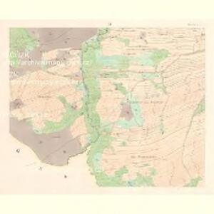
Albersdorf - c5777-1-004 - Kaiserpflichtexemplar der Landkarten des stabilen Katasters
1 : 2880
Albersdorf - c5777-1-002 - Kaiserpflichtexemplar der Landkarten des stabilen Katasters
1 : 2880
Albersdorf - c5777-1-003 - Kaiserpflichtexemplar der Landkarten des stabilen Katasters
1 : 2880
Albersdorf - c5777-1-001 - Kaiserpflichtexemplar der Landkarten des stabilen Katasters
1 : 2880
Brand - c4673-1-001 - Kaiserpflichtexemplar der Landkarten des stabilen Katasters
1 : 2880
Brand - c4673-1-002 - Kaiserpflichtexemplar der Landkarten des stabilen Katasters
1 : 2880
Brand - c4673-1-006 - Kaiserpflichtexemplar der Landkarten des stabilen Katasters
1 : 2880
Brand - c4673-1-007 - Kaiserpflichtexemplar der Landkarten des stabilen Katasters
1 : 2880
Brand - c4673-1-003 - Kaiserpflichtexemplar der Landkarten des stabilen Katasters
1 : 2880
Brand - c4673-1-005 - Kaiserpflichtexemplar der Landkarten des stabilen Katasters
1 : 2880
Brand - c4673-1-004 - Kaiserpflichtexemplar der Landkarten des stabilen Katasters
1 : 2880
Mapa revíru Milíře
1 : 11257
Přehledová mapa velkostatku Tachov
1 : 5747
Katastrální mapa obce Studánky
1 : 2880
Katastrální mapa obce Milíře
1 : 2880
Porostní mapa lesního hospodářského okresu A. Svatá, B. Studánka, C. Trnová
1 : 11493
Hospodářská mapa revíru Tachov-Studánka
1 : 5760
Katastrální mapa obce Studánky
1 : 2880
Hospodářská lesní mapa panství Tachov - část Obora

Lesní hospodářská mapa revíru Milíře
1 : 5747
Porostní mapa revíru Obora
1 : 11520
Mapa česko-bavorské hranice v prostoru sporného území mezi panstvím Tachov a bavorským městem Bärnau
1 : 12842
Předloha k porostní mapě revíru Milíře
1 : 11520
Porostní mapa revíru Milíře
1 : 11520
Předloha k porostní mapě revíru Milíře
1 : 11520
Hospodářská mapa revíru Milíře
1 : 5760
Porostní mapa revíru Obora
1 : 11671
Porostní mapa revíru Jalový Dvůr (Branka) a Horní Výšina
1 : 11520
Přehledová mapa velkostatku Tachov
1 : 5747
Schönwald - c3869-2-004 - Kaiserpflichtexemplar der Landkarten des stabilen Katasters
1 : 2880
Schönwald - c3869-2-002 - Kaiserpflichtexemplar der Landkarten des stabilen Katasters
1 : 2880
Schönwald - c3869-2-001 - Kaiserpflichtexemplar der Landkarten des stabilen Katasters
1 : 2880
Schönwald - c3869-2-006 - Kaiserpflichtexemplar der Landkarten des stabilen Katasters
1 : 2880
Schönwald - c3869-2-008 - Kaiserpflichtexemplar der Landkarten des stabilen Katasters
1 : 2880
Schönwald - c3869-2-003 - Kaiserpflichtexemplar der Landkarten des stabilen Katasters
1 : 2880
Schönwald - c3869-2-005 - Kaiserpflichtexemplar der Landkarten des stabilen Katasters
1 : 2880