Maps of Bor

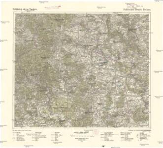
Politický okres Tachov
1 : 75000 Tachov (Česko : okres : 1960-) Vojenský zeměpisný ústav
Politický okres Tachov

Uibersichtskarte der Herrschaft Tachau
Tachov-oblast (Česko) Waraus, E. André Verlag des böhm. Forstvereins
III. vojenské mapování 4149
1 : 75000
Bestandeskarte des Hauptcomplexes der Domaine Tachau
1 : 29000 Tachov-oblast (Česko) Anderlik, Otto Verlag des böhm. Forstvereins
Hayder Vicariat
Bor-oblast (Tachov, Česko)

Pfraumberg
1 : 75000 Poběžovice (Domažlice, Česko : oblast) Kimlein K. u. k. militär-geographisches Institut
Pfraumberg
1 : 75000 Poběžovice (Domažlice, Česko : oblast) Kimlein K. u. k. Militärgeographisches Institut
Pfraumberg
1 : 75000 Přimda-oblast (Česko) K. u. k. Militärgeographisches Institut

Lesní přehledová mapa velkostatku Tachov
1 : 29327
[Kartenblatt]
1 : 25000 Bor (Tachov, Česko : oblast) Reichsamt für Landesaufnahme
Gradkartenblatt
1 : 25000 Přimda-oblast (Česko) Bulla, Eduard
III. vojenské mapování 4149/2
1 : 25000
III. vojenské mapování 4049/4
1 : 25000

Lesní přehledová mapa velkostatku Tachov
1 : 20173
Gradkartenblatt
1 : 25000 Tachov-oblast (Česko) Bulla, Eduard
Přehledná mapa panství Planá
1 : 25000
III. vojenské mapování 4149/1
1 : 25000
Přehledová mapa revírů Horní Výšina, Jalový Dvůr, Obora, Milíře, Pavlův Studenec, Zlatý Potok, Nový Losimtál
1 : 22942
[Kartenblatt]
1 : 25000 Planá (Tachov, Česko : oblast) Reichsamt für Landesaufnahme
Gradkartenblatt
1 : 25000 Čechy (Česko) Bulla, Eduard
III. vojenské mapování 4049/3
1 : 25000
Gradkartenblatt
1 : 25000 Rozvadov-oblast (Česko) Bulla, Eduard
Generalkarte der sämtlichen obrigkeitlichen Herrschaft Mayerhöfer Waldungen
Rozvadov-oblast (Česko) Biedermann, Kurt Walter, Maxmilian
Hospodářská lesní mapa panství Tachov - část Obora

Přehledová mapa velkostatku Tachov
1 : 17280