Maps of Tachov

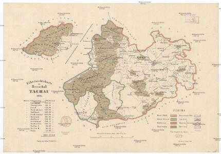
Uibersichtskarte der Herrschaft Tachau
Tachov-oblast (Česko) Waraus, E. André Verlag des böhm. Forstvereins
Hayder Vicariat
Bor-oblast (Tachov, Česko)
Bestandeskarte des Hauptcomplexes der Domaine Tachau
1 : 29000 Tachov-oblast (Česko) Anderlik, Otto Verlag des böhm. Forstvereins
Lesní přehledová mapa velkostatku Tachov
1 : 29327

Lesní přehledová mapa velkostatku Tachov
1 : 20173
Přehledná mapa panství Planá
1 : 25000
Přehledová mapa revírů Horní Výšina, Jalový Dvůr, Obora, Milíře, Pavlův Studenec, Zlatý Potok, Nový Losimtál
1 : 22942
III. vojenské mapování 4049/3
1 : 25000
Gradkartenblatt
1 : 25000 Čechy (Česko) Bulla, Eduard
III. vojenské mapování 4049/4
1 : 25000

Gradkartenblatt
1 : 25000 Tachov-oblast (Česko) Bulla, Eduard
[Kartenblatt]
1 : 25000 Planá (Tachov, Česko : oblast) Reichsamt für Landesaufnahme
[Kartenblatt]
1 : 25000 Halže (Česko) Reichsamt für Landesaufnahme
Mapa česko-bavorské hranice v prostoru panství Tachov, Planá a Chodová Planá
1 : 12842
Přehledová mapa velkostatku Tachov
1 : 17280
Hospodářská lesní mapa panství Tachov - část Obora

Přehledová mapa velkostatku Tachov
1 : 17280
Přehledová mapa velkostatku Tachov
1 : 17280
Přehledová mapa velkostatku Tachov
1 : 17280
Paulusbrunn - c5672-1-006 - Kaiserpflichtexemplar der Landkarten des stabilen Katasters
1 : 2880
Paulusbrunn - c5672-1-008 - Kaiserpflichtexemplar der Landkarten des stabilen Katasters
1 : 2880
Paulusbrunn - c5672-1-010 - Kaiserpflichtexemplar der Landkarten des stabilen Katasters
1 : 2880
Paulusbrunn - c5672-1-014 - Kaiserpflichtexemplar der Landkarten des stabilen Katasters
1 : 2880
Paulusbrunn - c5672-1-009 - Kaiserpflichtexemplar der Landkarten des stabilen Katasters
1 : 2880
Paulusbrunn - c5672-1-013 - Kaiserpflichtexemplar der Landkarten des stabilen Katasters
1 : 2880
Paulusbrunn - c5672-1-007 - Kaiserpflichtexemplar der Landkarten des stabilen Katasters
1 : 2880
Paulusbrunn - c5672-1-002 - Kaiserpflichtexemplar der Landkarten des stabilen Katasters
1 : 2880
Paulusbrunn - c5672-1-012 - Kaiserpflichtexemplar der Landkarten des stabilen Katasters
1 : 2880
Paulusbrunn - c5672-1-001 - Kaiserpflichtexemplar der Landkarten des stabilen Katasters
1 : 2880
Paulusbrunn - c5672-1-004 - Kaiserpflichtexemplar der Landkarten des stabilen Katasters
1 : 2880
Paulusbrunn - c5672-1-017 - Kaiserpflichtexemplar der Landkarten des stabilen Katasters
1 : 2880
Paulusbrunn - c5672-1-003 - Kaiserpflichtexemplar der Landkarten des stabilen Katasters
1 : 2880
Paulusbrunn - c5672-1-011 - Kaiserpflichtexemplar der Landkarten des stabilen Katasters
1 : 2880
Paulusbrunn - c5672-1-005 - Kaiserpflichtexemplar der Landkarten des stabilen Katasters
1 : 2880
Paulusbrunn - c5672-1-015 - Kaiserpflichtexemplar der Landkarten des stabilen Katasters
1 : 2880