Maps of Herzogtum Lauenburg

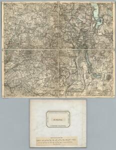
147. Ratzeburg. (Germany)
1 : 100000 Reichsamt fur Landesaufnahme
Composite: 147. Ratzeburg. (Germany)
1 : 100000 Reichsamt fur Landesaufnahme
Meßtischblatt 2430 : Gudow, 1900
1 : 250000 Gudow. - Hrsg. 1881, letzte Nachtr. 1900. - 1:25000. - [Berlin]: Reichsamt für Landesaufnahme, 1900. - 1 Kt.
Meßtischblatt 1033 : Siebeneichen, 1881
1 : 250000 Siebeneichen. - Aufn. 1879. - 1:25000. - [Berlin]: Reichsamt für Landesaufnahme, 1881. - 1 Kt.
Meßtischblatt 218 : Schwarzenbek, 1881
1 : 250000 Schwarzenbek. - Aufn. 1879. - 1:25000. - [Berlin]: Reichsamt für Landesaufnahme, 1881. - 1 Kt.
Meßtischblatt 938 : Mölln, 1881
1 : 250000 Mölln. - Aufn. 1879. - 1:25000. - [Berlin]: Reichsamt für Landesaufnahme, 1881. - 1 Kt.
Meßtischblatt Nusse
1 : 250000 Nusse. - Aufn. 1879. - 1:25000. - [Berlin]: Reichsamt für Landesaufnahme, 1881. - 1 Kt.
Meßtischblatt 936 : Trittau, 1881
1 : 250000 Trittau. - Aufn. 1879. - 1:25000. - [Berlin]: Reichsamt für Landesaufnahme, 1881. - 1 Kt.
Meßtischblatt 839 : Eichede, 1898
1 : 250000 Eichede. - Aufn. 1877/79, hrsg. 1881, einz. Nachtr. 1898. - 1:25000. - [Berlin]: Reichsamt für Landesaufnahme, 1898. - 1 Kt.
Meßtischblatt 840 : Crummesse, 1898
1 : 250000 Crummesse. - Aufn. 1877/79, hrsg. 1881, einz. Nachtr. 1898. - 1:25000. - [Berlin]: Reichsamt für Landesaufnahme, 1898. - 1 Kt.
Meßtischblatt 841, neue Nr. 2230 : Ratzeburg, 1937
1 : 250000 Ratzeburg. - Hrsg. 1881, einz. Nachtr. 1908, gedr. [19]37. - 1:25000. - [Berlin]: Reichsamt für Landesaufnahme, 1937. - 1 Kt.
Meßtischblatt 841 : Ratzeburg, 1908
1 : 250000 Ratzeburg. - Aufn. 1877/79, hrsg. 1881, einzelne Nachtr. 1908. - 1:25000. - [Berlin]: Reichsamt für Landesaufnahme, 1908. - 1 Kt.
Meßtischblatt 1031 : Glinde, 1933
1 : 250000 Glinde. - Hrsg. 1880, bericht. 1922. - 1:25000. - [Berlin]: Reichsamt für Landesaufnahme, 1933. - 1 Kt.
Meßtischblatt Ahrensburg
1 : 250000 Ahrensburg. - Hrsg. 1880, einz. Nachtr. 1928, gedr. - 1:25000. - [Berlin]: Reichsamt für Landesaufnahme, 1936. - 1 Kt.
Præfecturæ | Trittow, | Reinbeeck, | Tremsbüttel | et | Steinhorst.
Andras Lorensen, | Rodtgießer Husum. | sculps. [Amsterdam : Joan Blaeu]
146. Hamburg. (Germany)
1 : 100000 Reichsamt fur Landesaufnahme
41. Lübeck, uit: Topographische Uebersichtskarte des Deutschen Reiches / herausgegeben v. d. Kartogr. Abt. d. Königl. Preuß. Landesaufnahme
1 : 200000 titelvariant: Topogr. Übersichtskarte des Deutschen Reiches; Annotatie: Titel boven bladen ook: Topogr. Übersichtskarte des Deutschen Reiches; Annotatie geografische gegevens: Op elk blad twee maatstokken: 10 Kilometer = 5,5 cm; 1 geogr. Meile = 3,6 cm; Legenda onder op elk blad Königlich Preußische Landesaufnahme. Kartographische Abtheilung [S.l : Königlich Preußische Landesaufnahme, Kartographische Abtheilung]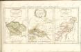

Meßtischblatt 838 : Bargteheide, 1910
1 : 250000 Bargteheide. - Aufn. 1878, hrsg. 1880, einz. Nachtr. 1910. - 1:25000. - [Berlin]: Reichsamt für Landesaufnahme, 1910. - 1 Kt.
Meßtischblatt 2530 : Gresse, 1938
1 : 250000 Gresse. - Hrsg. 1881, einz. Nachtr. 1910. - 1:25000. - [Berlin]: Reichsamt für Landesaufnahme, 1938. - 1 Kt.
Meßtischblatt 2529 : Büchen, 1952
1 : 250000 Büchen. - Hrsg. 1881, letzte Nachtr. 1924, Ausgabe 1924. - 1:25000. - [S.l.]: Vermessungsdienst des Landes Sachsen-Anhalt , 1952. - 1 Kt.
Meßtischblatt 1124 : Hamwarde, 1922
1 : 250000 Hamwarde. - Aufn. 1879, bericht. 1922. - 1:25000. - [Berlin]: Reichsamt für Landesaufnahme, 1922. - 1 Kt.

Typus Geographicus Ducat. Lauenburgici Novus
1 : 270000 Mollova mapová sbírka Homann, Johann Christoph Schneider, Ruprecht Adam Homann, Johann Baptista - dědici

[Herzogthum Holstein und Lauenburg, Fürstenthum Lübeck, Fr. Städte Hamburg und Lübeck nebst Amt Bergedorf]
Grosser Hand-Atlas über alle Theile der Erde in 170 Karten Meyer, J. Verlag des Bibliographischen Instituts
Holstein, Lauenburg, Lubeck, Hamburg.
1 : 440000 Meyer, Joseph, 1796-1856
Holstein, Lauenburg, Hamburg, Lubeck.
1 : 435000 Flemming, Carl
Tabvla Generalis Holsatiae complectens Holsatiae Dithmarsiae Stormariae et Vagriae Dvcatvs
1 : 310000 Mollova mapová sbírka Homann, Johann Baptist Homann, Johann Baptista