Maps of Herzogtum Lauenburg

41. Lübeck, uit: Topographische Uebersichtskarte des Deutschen Reiches / herausgegeben v. d. Kartogr. Abt. d. Königl. Preuß. Landesaufnahme
1 : 200000 titelvariant: Topogr. Übersichtskarte des Deutschen Reiches; Annotatie: Titel boven bladen ook: Topogr. Übersichtskarte des Deutschen Reiches; Annotatie geografische gegevens: Op elk blad twee maatstokken: 10 Kilometer = 5,5 cm; 1 geogr. Meile = 3,6 cm; Legenda onder op elk blad Königlich Preußische Landesaufnahme. Kartographische Abtheilung [S.l : Königlich Preußische Landesaufnahme, Kartographische Abtheilung]
58. Lauenburg a.d. Elbe, uit: Topographische Uebersichtskarte des Deutschen Reiches / herausgegeben v. d. Kartogr. Abt. d. Königl. Preuß. Landesaufnahme
1 : 200000 titelvariant: Topogr. Übersichtskarte des Deutschen Reiches; Annotatie: Titel boven bladen ook: Topogr. Übersichtskarte des Deutschen Reiches; Annotatie geografische gegevens: Op elk blad twee maatstokken: 10 Kilometer = 5,5 cm; 1 geogr. Meile = 3,6 cm; Legenda onder op elk blad Königlich Preußische Landesaufnahme. Kartographische Abtheilung [S.l : Königlich Preußische Landesaufnahme, Kartographische Abtheilung]
146. Hamburg. (Germany)
1 : 100000 Reichsamt fur Landesaufnahme
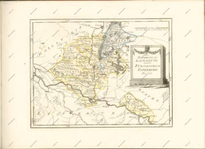
Præfecturæ | Trittow, | Reinbeeck, | Tremsbüttel | et | Steinhorst.
Andras Lorensen, | Rodtgießer Husum. | sculps. [Amsterdam : Joan Blaeu]
115. Schonberg in Mecklenbg. (Germany)
1 : 100000 Reichsamt fur Landesaufnahme
147. Ratzeburg. (Germany)
1 : 100000 Reichsamt fur Landesaufnahme
Composite: 147. Ratzeburg. (Germany)
1 : 100000 Reichsamt fur Landesaufnahme
Composite: 180. Hagenow. (Germany)
1 : 100000 Reichsamt fur Landesaufnahme
179. Lauenburg a. d. Elbe. (Germany)
1 : 100000 Reichsamt fur Landesaufnahme

Composite: 179. Lauenburg a. d. Elbe. (Germany)
1 : 100000 Reichsamt fur Landesaufnahme
Composite: 148. Wittenburg. (Germany)
1 : 100000 Reichsamt fur Landesaufnahme
180. Hagenow. (Germany)
1 : 100000 Reichsamt fur Landesaufnahme
148. Wittenburg. (Germany)
1 : 100000 Reichsamt fur Landesaufnahme
Composite: 115. Schonberg in Mecklenbg. (Germany)
1 : 100000 Reichsamt fur Landesaufnahme
114. Lubeck. (Germany)
1 : 100000 Reichsamt fur Landesaufnahme
Composite: 114. Lubeck. (Germany)
1 : 100000 Reichsamt fur Landesaufnahme
Germany 1:25,000, Luneberg
Germany 1:25,000 , Series GSGS 4414. Great Britain. War Office. [London] : War Office
Germany 1:25,000, Kirchgellersen
Germany 1:25,000 , Series GSGS 4414. Great Britain. War Office. [London] : War Office
Meßtischblatt 2733 : Leussow, 1939
1 : 250000 Leussow. - Hrsg. 1881, ber. 1906, einz. Nachtr. 1939. - 1:25000. - [Berlin]: Reichsamt für Landesaufnahme, 1939. - 1 Kt.
Meßtischblatt 2732 : Jessenitz, 1953
1 : 250000 Jessenitz. - Hrsg. 1900, bericht. 1906, letzte Nachtr. 1939. - 1:25000. - [S.l.]: 1953. - 1 Kt.
Meßtischblatt 1303 : Neuhaus a. d. Elbe, 1938
1 : 250000 Neuhaus a. d. Elbe. - Hrsg. 1881, bericht. 1906, einz. Nachtr. 1919, redakt. Änd. 1938. - 1:25000. - [Berlin]: Reichsamt für Landesaufnahme, 1938. - 1 Kt.
Meßtischblatt 1303 : Neuhaus a. d. Elbe, 1913
1 : 250000 Neuhaus a. d. Elbe. - Aufn. 1879, hrsg. 1881, Auflagedr. 1913. - 1:25000. - [Berlin]: Reichsamt für Landesaufnahme, 1913. - 1 Kt.
Meßtischblatt 1302 : Bleckede, 1901
1 : 250000 Bleckede. - Aufn. 1879/99. - 1:25000. - [Berlin]: Reichsamt für Landesaufnahme, 1901. - 1 Kt.
Meßtischblatt 1301 : Neetze, 1901
1 : 250000 Neetze. - Aufn. 1879/99, hrsg. 1901. - 1:25000. - [Berlin]: Reichsamt für Landesaufnahme, 1901. - 1 Kt.
Meßtischblatt 1300 : Lüneburg, 1910
1 : 250000 Lüneburg. - bericht. 1899, einz. Nachtr. 1910. - 1:25000. - [Berlin]: Reichsamt für Landesaufnahme, 1910. - 1 Kt.
Meßtischblatt 1300 : Lüneburg, 1881
1 : 250000 Lüneburg. - Aufn. 1879. - 1:25000. - [Berlin]: Reichsamt für Landesaufnahme, 1881. - 1 Kt.
Meßtischblatt 1299 : Kirchgellersen, 1901
1 : 250000 Kirchgellersen. - Aufn. 1878/99. - 1:25000. - [Berlin]: Reichsamt für Landesaufnahme, 1901. - 1 Kt.