Maps of Geesthacht

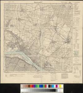
Meßtischblatt 1124 : Hamwarde, 1922
1 : 250000 Hamwarde. - Aufn. 1879, bericht. 1922. - 1:25000. - [Berlin]: Reichsamt für Landesaufnahme, 1922. - 1 Kt.
Composite: 179. Lauenburg a. d. Elbe. (Germany)
1 : 100000 Reichsamt fur Landesaufnahme
179. Lauenburg a. d. Elbe. (Germany)
1 : 100000 Reichsamt fur Landesaufnahme
Celeberrimi Fluvii Albis nova delineatio [Karte, Teil 1], in: Le théâtre du monde, ou, Nouvel atlas contenant les chartes et descriptions de tous les païs de la terre, Bd. 1, S. 148.
1 Karte aus Atlas Blaeu, Willem Janszoon und Blaeu, Joan Blaeu, Willem Janszoon
Celeberrimi Fluvii Albis nova delineatio [Karte, Teil 1], in: Novus Atlas, das ist, Weltbeschreibung, Bd. 1, S. 117.
1 Karte aus Atlas Blaeu, Joan Blaeu, Willem Janszoon
Nobilis fluvius Albis : maximâ curâ, ex varijs, famosisq. ... / a Nicolao Johannide Piscatore
1 : 152900 Annotatie: Origineel is Blad 81 in atlas factice; Annotatie geografische gegevens: Schaalstok: 2 Miliaria Germanica communia quorum 15 gradum unum latitudinis constituunt = 9 cm; Zuid boven; Inzet: Emporium Hamburgum Claes Jansz. Visscher 1586/1587-1652 [S.l. : s.n.]
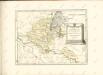
Præfecturæ | Trittow, | Reinbeeck, | Tremsbüttel | et | Steinhorst.
Andras Lorensen, | Rodtgießer Husum. | sculps. [Amsterdam : Joan Blaeu]
Tabula Geographica novissima Ducatus Stormariae in Meridionali parte Holsatiae
1 : 210000 Mollova mapová sbírka Schenk, Pieter Schenk, Peter I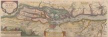
Nobilis Fluvius Albis maximâ curâ, ex variis famosisque Autoribus collectus, et in lucem editus. [Karte, Teil 1], in: Novus atlas absolutissimus, Bd. 2, S. 33.
1 Karte aus Atlas Janssonius Offizin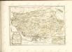
Celeberrimi Fluvii Albis nova delineatio [Karte, Teil 1], in: Theatrum orbis terrarum, sive, Atlas novus, Bd. 1, S. 182.
1 Karte aus Atlas Blaeu, Joan Blaeu, Willem Janszoon
Tabula geographica novissima ducatus Stormariae in meridionali parte Holsatiae
1 : 209000 Holštýnsko Schenk, Pieter Valk, Gerhard apud P. Schenk et G. Valk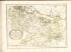

STORMARIA | DVCATVS
Auctore Joh: Meyer Husumensi. Matthias & Nicolaus Peters | Goldtschmide gebr. Hus. sculp. [Amsterdam : Joan Blaeu]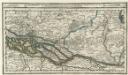
Hamburg mit dero Gegend Oostwerts bis Lauenburg Sampt denen in Gemeinschaft Lubeck besitzenden Vier Laendern.
1 : 320000 Mollova mapová sbírka Bodenehr, Gabriel Bodenehr, Gabriel
Hamburg 33, uit: Special-Karte von Mittel-Europa / nach amtlichen Quellen bearbeitet von W. Liebenow
1 : 300000 titelvariant: W. Liebenow's Mittel-Europa; Annotatie: Titel boven de bladen: W. Liebenow's Mittel-Europa Johannes Wilhelm Liebenow 1822-1897 Frankfurt a. M. : Ludwig Ravenstein
Typus Geographicus Ducat. Lauenburgici Novus
1 : 270000 Mollova mapová sbírka Homann, Johann Christoph Schneider, Ruprecht Adam Homann, Johann Baptista - dědici
Tabula Geographica novissima Ducatus Stormariae, in Meridionali parte Holsatiae. [Karte], in: Novus atlas absolutissimus, Bd. 1, S. 152.
1 Karte aus Atlas Janssonius Offizin

[Herzogthum Holstein und Lauenburg, Fürstenthum Lübeck, Fr. Städte Hamburg und Lübeck nebst Amt Bergedorf]
Grosser Hand-Atlas über alle Theile der Erde in 170 Karten Meyer, J. Verlag des Bibliographischen Instituts
Holstein, Lauenburg, Lubeck, Hamburg.
1 : 440000 Meyer, Joseph, 1796-1856
Holstein, Lauenburg, Hamburg, Lubeck.
1 : 435000 Flemming, Carl
Tabvla Generalis Holsatiae complectens Holsatiae Dithmarsiae Stormariae et Vagriae Dvcatvs
1 : 310000 Mollova mapová sbírka Homann, Johann Baptist Homann, Johann Baptista
Tabvla Generalis Holsatiae complectens Holsatiae Dithmarsiae Stormariae et Vagriae Dvcatvs
1 : 310000 Mollova mapová sbírka Homann, Johann Baptist Homann, Johann Baptista

Holsatiae Tabula Generalis in qua sunt Ducatus Holsatiae Ditmarsiae Stormariae et Wagriae
1 : 310000 Mollova mapová sbírka Schenk, Pieter Schenk, Peter I

DUCATUS BREMAE et FERDAE, Maximaeque partis DUCATUS STORMARIAE, COMITATUS OLDENBURGI, ALBIS, VISURGISQUE FLUMINUM Novissima Descriptio
1 : 330000 Labe-oblast (Česko a Německo) Visscher, Nicolaus per Nicolaum Visscher
Holsatiae Dithmarsiae Stormariae et Vagriae Dvcatvs
1 : 480000 Mollova mapová sbírka Weigel, Christoph Kauffer, Michael Weigel, Christoph I.