Maps of Sandesneben-Nusse

Composite: 147. Ratzeburg. (Germany)
1 : 100000 Reichsamt fur Landesaufnahme
147. Ratzeburg. (Germany)
1 : 100000 Reichsamt fur Landesaufnahme
Meßtischblatt 938 : Mölln, 1881
1 : 250000 Mölln. - Aufn. 1879. - 1:25000. - [Berlin]: Reichsamt für Landesaufnahme, 1881. - 1 Kt.
Meßtischblatt Nusse
1 : 250000 Nusse. - Aufn. 1879. - 1:25000. - [Berlin]: Reichsamt für Landesaufnahme, 1881. - 1 Kt.
Meßtischblatt 936 : Trittau, 1881
1 : 250000 Trittau. - Aufn. 1879. - 1:25000. - [Berlin]: Reichsamt für Landesaufnahme, 1881. - 1 Kt.
Meßtischblatt 2430 : Gudow, 1900
1 : 250000 Gudow. - Hrsg. 1881, letzte Nachtr. 1900. - 1:25000. - [Berlin]: Reichsamt für Landesaufnahme, 1900. - 1 Kt.
Meßtischblatt 1033 : Siebeneichen, 1881
1 : 250000 Siebeneichen. - Aufn. 1879. - 1:25000. - [Berlin]: Reichsamt für Landesaufnahme, 1881. - 1 Kt.
Meßtischblatt 218 : Schwarzenbek, 1881
1 : 250000 Schwarzenbek. - Aufn. 1879. - 1:25000. - [Berlin]: Reichsamt für Landesaufnahme, 1881. - 1 Kt.
Meßtischblatt 839 : Eichede, 1898
1 : 250000 Eichede. - Aufn. 1877/79, hrsg. 1881, einz. Nachtr. 1898. - 1:25000. - [Berlin]: Reichsamt für Landesaufnahme, 1898. - 1 Kt.
Meßtischblatt 840 : Crummesse, 1898
1 : 250000 Crummesse. - Aufn. 1877/79, hrsg. 1881, einz. Nachtr. 1898. - 1:25000. - [Berlin]: Reichsamt für Landesaufnahme, 1898. - 1 Kt.
Meßtischblatt 841, neue Nr. 2230 : Ratzeburg, 1937
1 : 250000 Ratzeburg. - Hrsg. 1881, einz. Nachtr. 1908, gedr. [19]37. - 1:25000. - [Berlin]: Reichsamt für Landesaufnahme, 1937. - 1 Kt.
Meßtischblatt 841 : Ratzeburg, 1908
1 : 250000 Ratzeburg. - Aufn. 1877/79, hrsg. 1881, einzelne Nachtr. 1908. - 1:25000. - [Berlin]: Reichsamt für Landesaufnahme, 1908. - 1 Kt.
Præfecturæ | Trittow, | Reinbeeck, | Tremsbüttel | et | Steinhorst.
Andras Lorensen, | Rodtgießer Husum. | sculps. [Amsterdam : Joan Blaeu]
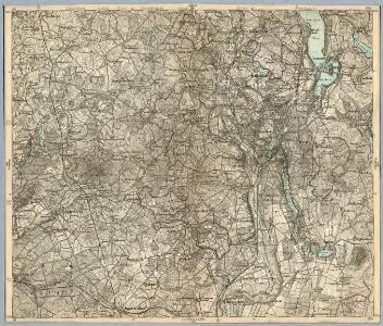
41. Lübeck, uit: Topographische Uebersichtskarte des Deutschen Reiches / herausgegeben v. d. Kartogr. Abt. d. Königl. Preuß. Landesaufnahme
1 : 200000 titelvariant: Topogr. Übersichtskarte des Deutschen Reiches; Annotatie: Titel boven bladen ook: Topogr. Übersichtskarte des Deutschen Reiches; Annotatie geografische gegevens: Op elk blad twee maatstokken: 10 Kilometer = 5,5 cm; 1 geogr. Meile = 3,6 cm; Legenda onder op elk blad Königlich Preußische Landesaufnahme. Kartographische Abtheilung [S.l : Königlich Preußische Landesaufnahme, Kartographische Abtheilung]

Meßtischblatt Ahrensburg
1 : 250000 Ahrensburg. - Hrsg. 1880, einz. Nachtr. 1928, gedr. - 1:25000. - [Berlin]: Reichsamt für Landesaufnahme, 1936. - 1 Kt.
Meßtischblatt 1031 : Glinde, 1933
1 : 250000 Glinde. - Hrsg. 1880, bericht. 1922. - 1:25000. - [Berlin]: Reichsamt für Landesaufnahme, 1933. - 1 Kt.
Meßtischblatt 838 : Bargteheide, 1910
1 : 250000 Bargteheide. - Aufn. 1878, hrsg. 1880, einz. Nachtr. 1910. - 1:25000. - [Berlin]: Reichsamt für Landesaufnahme, 1910. - 1 Kt.

146. Hamburg. (Germany)
1 : 100000 Reichsamt fur Landesaufnahme
Typus Geographicus Ducat. Lauenburgici Novus
1 : 270000 Mollova mapová sbírka Homann, Johann Christoph Schneider, Ruprecht Adam Homann, Johann Baptista - dědici
Tabula Geographica novissima Ducatus Stormariae, in Meridionali parte Holsatiae. [Karte], in: Novus atlas absolutissimus, Bd. 1, S. 152.
1 Karte aus Atlas Janssonius Offizin
Tabula geographica novissima ducatus Stormariae in meridionali parte Holsatiae
1 : 209000 Holštýnsko Schenk, Pieter Valk, Gerhard apud P. Schenk et G. Valk
STORMARIA | DVCATVS
Auctore Joh: Meyer Husumensi. Matthias & Nicolaus Peters | Goldtschmide gebr. Hus. sculp. [Amsterdam : Joan Blaeu]
Hamburg 33, uit: Special-Karte von Mittel-Europa / nach amtlichen Quellen bearbeitet von W. Liebenow
1 : 300000 titelvariant: W. Liebenow's Mittel-Europa; Annotatie: Titel boven de bladen: W. Liebenow's Mittel-Europa Johannes Wilhelm Liebenow 1822-1897 Frankfurt a. M. : Ludwig Ravenstein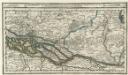
Hamburg mit dero Gegend Oostwerts bis Lauenburg Sampt denen in Gemeinschaft Lubeck besitzenden Vier Laendern.
1 : 320000 Mollova mapová sbírka Bodenehr, Gabriel Bodenehr, Gabriel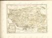

Tabula Geographica novissima Ducatus Stormariae in Meridionali parte Holsatiae
1 : 210000 Mollova mapová sbírka Schenk, Pieter Schenk, Peter I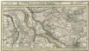
Hamburg mit dero Gegend Westwerts, die Elbe hinunter zu fahren Bis Gluckstadt.
1 : 320000 Mollova mapová sbírka Bodenehr, Gabriel Bodenehr, Gabriel