Maps of Lütau

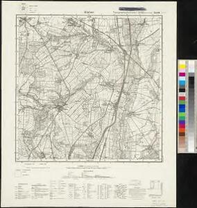
Meßtischblatt 2529 : Büchen, 1952
1 : 250000 Büchen. - Hrsg. 1881, letzte Nachtr. 1924, Ausgabe 1924. - 1:25000. - [S.l.]: Vermessungsdienst des Landes Sachsen-Anhalt , 1952. - 1 Kt.
Composite: 179. Lauenburg a. d. Elbe. (Germany)
1 : 100000 Reichsamt fur Landesaufnahme
179. Lauenburg a. d. Elbe. (Germany)
1 : 100000 Reichsamt fur Landesaufnahme
Præfecturæ | Trittow, | Reinbeeck, | Tremsbüttel | et | Steinhorst.
Andras Lorensen, | Rodtgießer Husum. | sculps. [Amsterdam : Joan Blaeu]
58. Lauenburg a.d. Elbe, uit: Topographische Uebersichtskarte des Deutschen Reiches / herausgegeben v. d. Kartogr. Abt. d. Königl. Preuß. Landesaufnahme
1 : 200000 titelvariant: Topogr. Übersichtskarte des Deutschen Reiches; Annotatie: Titel boven bladen ook: Topogr. Übersichtskarte des Deutschen Reiches; Annotatie geografische gegevens: Op elk blad twee maatstokken: 10 Kilometer = 5,5 cm; 1 geogr. Meile = 3,6 cm; Legenda onder op elk blad Königlich Preußische Landesaufnahme. Kartographische Abtheilung [S.l : Königlich Preußische Landesaufnahme, Kartographische Abtheilung]
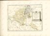
Tabula geographica novissima ducatus Stormariae in meridionali parte Holsatiae
1 : 209000 Holštýnsko Schenk, Pieter Valk, Gerhard apud P. Schenk et G. Valk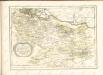

STORMARIA | DVCATVS
Auctore Joh: Meyer Husumensi. Matthias & Nicolaus Peters | Goldtschmide gebr. Hus. sculp. [Amsterdam : Joan Blaeu]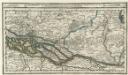
Hamburg mit dero Gegend Oostwerts bis Lauenburg Sampt denen in Gemeinschaft Lubeck besitzenden Vier Laendern.
1 : 320000 Mollova mapová sbírka Bodenehr, Gabriel Bodenehr, Gabriel
Hamburg 33, uit: Special-Karte von Mittel-Europa / nach amtlichen Quellen bearbeitet von W. Liebenow
1 : 300000 titelvariant: W. Liebenow's Mittel-Europa; Annotatie: Titel boven de bladen: W. Liebenow's Mittel-Europa Johannes Wilhelm Liebenow 1822-1897 Frankfurt a. M. : Ludwig Ravenstein
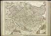
Typus Geographicus Ducat. Lauenburgici Novus
1 : 270000 Mollova mapová sbírka Homann, Johann Christoph Schneider, Ruprecht Adam Homann, Johann Baptista - dědici
Tabula Geographica novissima Ducatus Stormariae, in Meridionali parte Holsatiae. [Karte], in: Novus atlas absolutissimus, Bd. 1, S. 152.
1 Karte aus Atlas Janssonius Offizin

[Herzogthum Holstein und Lauenburg, Fürstenthum Lübeck, Fr. Städte Hamburg und Lübeck nebst Amt Bergedorf]
Grosser Hand-Atlas über alle Theile der Erde in 170 Karten Meyer, J. Verlag des Bibliographischen Instituts
Holstein, Lauenburg, Lubeck, Hamburg.
1 : 440000 Meyer, Joseph, 1796-1856
Holstein, Lauenburg, Hamburg, Lubeck.
1 : 435000 Flemming, Carl
Tabvla Generalis Holsatiae complectens Holsatiae Dithmarsiae Stormariae et Vagriae Dvcatvs
1 : 310000 Mollova mapová sbírka Homann, Johann Baptist Homann, Johann Baptista
Tabvla Generalis Holsatiae complectens Holsatiae Dithmarsiae Stormariae et Vagriae Dvcatvs
1 : 310000 Mollova mapová sbírka Homann, Johann Baptist Homann, Johann Baptista

Holsatiae Tabula Generalis in qua sunt Ducatus Holsatiae Ditmarsiae Stormariae et Wagriae
1 : 310000 Mollova mapová sbírka Schenk, Pieter Schenk, Peter I

Holsatiae Dithmarsiae Stormariae et Vagriae Dvcatvs
1 : 480000 Mollova mapová sbírka Weigel, Christoph Kauffer, Michael Weigel, Christoph I.
Herzogthum Holstein im Nieder Sächsischen Creisse mit seinen abgetheilten Provintzien
Mollova mapová sbírka Weigel, Christoph Weigel, Christoph I.
Ducatus Luneburgicus cum comitatu Dannebergensi
1 : 336000 Lüneburg (Německo) Seutter, Matthäus Matth. Seutter

Tabvla generalis Holsatiae complectens Holsatiae Dithmarsiae Stormariae et Vargiae dvcatvs
1 : 316000 Holštýnsko Homann, Johann Baptist a Ioh. Bapt. Homanno
Ducatus Luneburgici et comitatus Dannenbergensis
1 : 363000 Lüneburg (Německo) Visscher, Nicolaus Schenk, Pieter Pet. Schenk Iun.
Tabula Generalis Holsatiae
1 : 310000 Mollova mapová sbírka Danckerts, Theodorus Danckerts, Theodor