Maps of gmina Barczewo

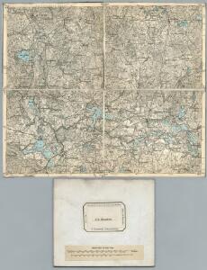
134. Allenstein. (Germany)
1 : 100000 Reichsamt fur Landesaufnahme
Composite: 134. Allenstein. (Germany)
1 : 100000 Reichsamt fur Landesaufnahme
Meßtischblatt 2189 : Alt Wartenburg, 1938
1 : 250000 Alt Wartenburg. - Hrsg. 1914, einz. Nachtr. 1929, redakt. Änd. 193. - 1:25000. - [Berlin]: Reichsamt für Landesaufnahme, 1938. - 1 Kt.
Meßtischblatt 2190 : Wartenburg, 1938
1 : 250000 Wartenburg. - Hrsg. 1915, einz. Nachtr. 1929, redakt. Änd. 193. - 1:25000. - [Berlin]: Reichsamt für Landesaufnahme, 1938. - 1 Kt.
Meßtischblatt 2089 : Freudenberg, 1915
1 : 250000 Freudenberg. - Aufn. 1912. - 1:25000. - [Berlin]: Reichsamt für Landesaufnahme, 1915. - 1 Kt.
Meßtischblatt 2090 : Seeburg, 1936
1 : 250000 Seeburg. - Hrsg. 1915, Nachtr. 1921, gedr. [19]36. - 1:25000. - [Berlin]: Reichsamt für Landesaufnahme, 1936. - 1 Kt.
Meßtischblatt 2188 : Göttkendorf, 1938
1 : 250000 Göttkendorf. - Hrsg. 1915, einz. Nachtr. 1929, redakt. Änd. 193. - 1:25000. - [Berlin]: Reichsamt für Landesaufnahme, 1938. - 1 Kt.
Meßtischblatt 2088 : Guttstadt, 1938
1 : 250000 Guttstadt. - Hrsg. 1914, red. Änd. 1938. - 1:25000. - [Berlin]: Reichsamt für Landesaufnahme, 1938. - 1 Kt.
Meßtischblatt 2290 : Gr. Purden, 1938
1 : 250000 Gr. Purden. - Hrsg. 1914, bericht. 1929, redakt. Änd. 1938. - 1:25000. - [Berlin]: Reichsamt für Landesaufnahme, 1938. - 1 Kt.
Meßtischblatt 2289 : Gr. Kleeberg, 1929
1 : 250000 Gr. Kleeberg. - Hrsg. 1914, bericht. 1929. - 1:25000. - [Berlin]: Reichsamt für Landesaufnahme, 1929. - 1 Kt.
Meßtischblatt Allenstein
1 : 250000 Allenstein. - Hrsg. 1914, bericht. 1929, redakt. Änd. 1938. - 1:25000. - [Berlin]: Reichsamt für Landesaufnahme, 1938. - 1 Kt.
Composite: 73. Heiligenbeil. (Germany)
1 : 100000 Reichsamt fur Landesaufnahme
Karte von Ermeland oder zweites Blat von Westpreussen
1 : 225000 Prusko Západní Endersch, Johann Friedrich Amon, Anton F.A. Schraembl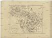
Karte von Ermeland oder zweites Blat von Westpreussen
1 : 225000 Prusko Západní Endersch, Johann Friedrich Amon, Anton F.A. Schraembl
Karte von Ermeland oder zweites Blat von Westpreussen
1 : 225000 Prusko Západní Endersch, Johann Friedrich Amon, Anton F.A. Schraembl
Tabvla geographica episcopatvm Warmiensem in Prvssia exhibens, Heilsberg, solita habitatio episcopalis, longitudinem 38. graduum, et 16. minutorum ab insula Ferro numerat
1 : 220000 Lidzbark Warmiński-oblast (Polsko) Endersch, Johann Friedrich Grabowski, Adam Stanisław Ioannes Fridericus Endersch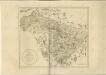

28 Lötzen, uit: Special-Karte von Mittel-Europa / nach amtlichen Quellen bearbeitet von W. Liebenow
1 : 300000 titelvariant: W. Liebenow's Mittel-Europa; Annotatie: Titel boven de bladen: W. Liebenow's Mittel-Europa Johannes Wilhelm Liebenow 1822-1897 Frankfurt a. M. : Ludwig Ravenstein
Karte vom Kreise Rössel, Reg. Bez. Königsberg
Karte vom Kreise Rössel, Reg. Bez. Königsberg, gefestigt und herausgegeben von G. Schamberg's lithographischer Anstalt. Königsberg
Östlicher Kriegsschauplatz II: Schlacht bei Tannenberg
1 : 750000 Tannenberg Schlacht bei Tannenberg <1914>
Operationskarte
1 : 300000 Annotatie: Uit Bd. 4 van: Der Krieg von 1806 und 1807 / O. von Lettow-Vorbeck. - Berlin : Mittler, 1896; Fotogr. reprod. van origineel uit: Der Krieg von 1806 und 1807 ... / E. von Höpfner. - Berlin : Schropp, 1850 Berlin : Mittler

Sect. 11: Allenstein, uit: Geologische Karte des Deutschen Reichs in 27 Blaettern / [von] Richard Lepsius ; Red. von C. Vogel
1 : 500000 Annotatie: Blad 18 ontbreekt; Een aantal bladen op linnen; Een aantal bladen gereviseerd 1913-1914; Annotatie geografische gegevens: Met schaalstokken o.a. in kilometers; Legenda Carl Vogel 1828-1897 Gotha : Justus Perthes
Provinz Ostpreussen
1 : 1250000 Ostpreußen
Litauisch und Masurisch
Ostpreußen Litauisch, Masurisch
Prvssia
1 Karte : Kupferdruck ; 35 x 47 cm Mercator; Hondius Henricus Hondius
Königsberg, Guttstadt, Biełostok, Suwałki
1 : 750000 Białystok (Polsko : oblast) Konrad, Adalbert K. u. k. Militärgeographisches Institut
Königsberg, Guttstadt, Bielostok, Suwalki
1 : 750000 Białystok (Polsko : oblast) K. k. militär-geographisches Institut
Ost-Preussen.
1 : 935000 Flemming, Carl