Maps of Bartąg

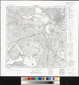
Meßtischblatt Allenstein
1 : 250000 Allenstein. - Hrsg. 1914, bericht. 1929, redakt. Änd. 1938. - 1:25000. - [Berlin]: Reichsamt für Landesaufnahme, 1938. - 1 Kt.
134. Allenstein. (Germany)
1 : 100000 Reichsamt fur Landesaufnahme
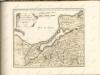
Composite: 167. Passenheim. (Germany)
1 : 100000 Reichsamt fur Landesaufnahme
Östlicher Kriegsschauplatz II: Schlacht bei Tannenberg
1 : 750000 Tannenberg Schlacht bei Tannenberg <1914>
Composite: 73. Heiligenbeil. (Germany)
1 : 100000 Reichsamt fur Landesaufnahme
Elbing 27, uit: Special-Karte von Mittel-Europa / nach amtlichen Quellen bearbeitet von W. Liebenow
1 : 300000 titelvariant: W. Liebenow's Mittel-Europa; Annotatie: Titel boven de bladen: W. Liebenow's Mittel-Europa Johannes Wilhelm Liebenow 1822-1897 Frankfurt a. M. : Ludwig Ravenstein
Tabvla geographica episcopatvm Warmiensem in Prvssia exhibens, Heilsberg, solita habitatio episcopalis, longitudinem 38. graduum, et 16. minutorum ab insula Ferro numerat
1 : 220000 Lidzbark Warmiński-oblast (Polsko) Endersch, Johann Friedrich Grabowski, Adam Stanisław Ioannes Fridericus Endersch

Operationskarte
1 : 300000 Annotatie: Uit Bd. 4 van: Der Krieg von 1806 und 1807 / O. von Lettow-Vorbeck. - Berlin : Mittler, 1896; Fotogr. reprod. van origineel uit: Der Krieg von 1806 und 1807 ... / E. von Höpfner. - Berlin : Schropp, 1850 Berlin : Mittler
Regni Borussiae Episcopatus Warmiensis Palatinatus Mariaeburgensis et Culmensis cum Territorio Dantiscano et Ichnographia Urbis Regiomontis].
Mollova mapová sbírka

Sect. 11: Allenstein, uit: Geologische Karte des Deutschen Reichs in 27 Blaettern / [von] Richard Lepsius ; Red. von C. Vogel
1 : 500000 Annotatie: Blad 18 ontbreekt; Een aantal bladen op linnen; Een aantal bladen gereviseerd 1913-1914; Annotatie geografische gegevens: Met schaalstokken o.a. in kilometers; Legenda Carl Vogel 1828-1897 Gotha : Justus Perthes
Provinz Ostpreussen
1 : 1250000 Ostpreußen
Litauisch und Masurisch
Ostpreußen Litauisch, Masurisch
Prvssia
1 Karte : Kupferdruck ; 35 x 47 cm Mercator; Hondius Henricus Hondius
Königsberg, Guttstadt, Biełostok, Suwałki
1 : 750000 Białystok (Polsko : oblast) Konrad, Adalbert K. u. k. Militärgeographisches Institut
Königsberg, Guttstadt, Bielostok, Suwalki
1 : 750000 Białystok (Polsko : oblast) K. k. militär-geographisches Institut
Ost-Preussen.
1 : 935000 Flemming, Carl
Übersichtskarte von Mittel - Europa

Übersichtskarte von Mittel - Europa

Schema Teatra kampanīi 1806-7 gg.
Polen Napoleonische Kriege
Plan einer trigonometrischen Ausmessung welche in den Jahren 1796 und 1797 in Ostpreussen und Lithauen ausgeführt worden
1 : 800000 Landes-Industrie-Comptoir
Prvssiae nova tabvla
1 : 1100000 Mollova mapová sbírka Merian, Matthäus Merian, Matthäus - dědici
[Recto], uit: Archangel Port : revised plan of saw mills and loading places
1 : 90000 Annotatie geografische gegevens: Met legenda, 1-45 Archangel : A.J. Anderson & Son

Provinz Ost - Preussen

West Preussen.
1 : 940000 Flemming, Carl
Regnum Borussiae gloriosis auspiciis serenissimi et potentissimi princip. Friderici III primi Borussiae regis march. et elect. Brandenburg inauguratum die 18 Jan A 1701
1 : 760000 Prusko Homann, Johann Baptist J.B. Homann
REGNUM BORUSSIAE Gloriosis auspiciis Serenissimi et Potentissimi Pri. FRIDERICI III PRIMI BORUSSIAE REGIS, MARCH. ET ELECT. BRAN. inauguratum die 18. Ian A. 1701 Geographice cum vicinis Regionibus adumbratum
1 : 750000 Prusko Homann, Johann Baptist a Ioh. Baptista Homanno
Regnum Borussiae gloriosis auspiciis serenissimi et potentissimi prin Friderici III primi Borussiae regis, march. et elect. Brandenburg inauguratum die 18. Ian A. 1701
1 : 760000 Prusko Homann, Johann Baptist a Ioh Baptista Homanno
Regnum Borussiae gloriosis auspiciis serenissimi et potentissimi prin Friderici III primi Borussiae regis, march. et elect. Bran inauguratum die 18. Ian. A. 1701
1 : 760000 Prusko Homann, Johann Baptist a Ioh. Baptista Homanno
Regnum Borussiae gloriosis auspiciis serenissimi et potentissimi princ. Friderici III primi Borussiae regis, march. et elect. Brand. inauguratum die 18. Ian. A. 1701
1 : 760000 Prusko Homann, Johann Baptist a Ioh. Baptista Homanno