Maps of powiat olsztyński

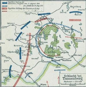
Östlicher Kriegsschauplatz II: Schlacht bei Tannenberg
1 : 750000 Tannenberg Schlacht bei Tannenberg <1914>
Composite: 199.1. Neidenburg. 230.1. Bialutten. (Germany)
1 : 100000 Reichsamt fur Landesaufnahme
199.1. Neidenburg. 230.1 Bialutten. (Germany)
1 : 100000 Reichsamt fur Landesaufnahme
Composite: 230.1. (199.1. Neidenburg). Bialutten.
1 : 100000 Reichsamt fur Landesaufnahme
230. (199. Neidenburg). Bialutten.
1 : 100000 Reichsamt fur Landesaufnahme
199. Neidenburg. (230. Bialutten) (Germany)
1 : 100000 Reichsamt fur Landesaufnahme
230.1. (199.1Neidenburg). Bialutten.
1 : 100000 Reichsamt fur Landesaufnahme
Composite: 167. Passenheim. (Germany)
1 : 100000 Reichsamt fur Landesaufnahme
198. Gilgenburg. (Germany)
1 : 100000 Reichsamt fur Landesaufnahme
167. Passenheim. (Germany)
1 : 100000 Reichsamt fur Landesaufnahme
Composite: 198. Gilgenburg. (Germany)
1 : 100000 Reichsamt fur Landesaufnahme
Composite: 200. Willenberg. (Germany)
1 : 100000 Reichsamt fur Landesaufnahme
Composite: 134. Allenstein. (Germany)
1 : 100000 Reichsamt fur Landesaufnahme
Composite: 133. Mohrungen. (Germany)
1 : 100000 Reichsamt fur Landesaufnahme
134. Allenstein. (Germany)
1 : 100000 Reichsamt fur Landesaufnahme
Composite: 229. Soldau.
1 : 100000 Reichsamt fur Landesaufnahme
168. Ortelsburg. (Germany)
1 : 100000 Reichsamt fur Landesaufnahme
Composite: 168. Ortelsburg. (Germany)
1 : 100000 Reichsamt fur Landesaufnahme
Meßtischblatt 2888 : Mlawa, 1940
1 : 250000 Mlawa. - Aufn. 1909, letzte Nachtr. 1928 (nach Polen 1935. - 1:25000. - [Berlin]: Reichsamt für Landesaufnahme, 1940. - 1 Kt.
Meßtischblatt 2886 : Königshagen, 1940
1 : 250000 Königshagen. - Aufn. 1909, letzte Nachtr. 1929/30. - 1:25000. - [Berlin]: Reichsamt für Landesaufnahme, 1940. - 1 Kt.
Meßtischblatt 2885 : Neu- Zielun, 1940
1 : 250000 Neu- Zielun. - Aufn. 1909, letzte Nachtr. 1929/30. - 1:25000. - [Berlin]: Reichsamt für Landesaufnahme, 1940. - 1 Kt.
Meßtischblatt 2887 : Illowo, 1910
1 : 250000 Illowo. - Aufn. 1909. - 1:25000. - [Berlin]: Reichsamt für Landesaufnahme, 1910. - 1 Kt.
Meßtischblatt 2791 : Flammberg, 1940
1 : 250000 Flammberg. - Aufn. 1910, bericht. 1927. - 1:25000. - [Berlin]: Reichsamt für Landesaufnahme, 1940. - 1 Kt.
Meßtischblatt 2788 : Bartkenguth, 1940
1 : 250000 Bartkenguth. - Hrsg. 1910, einz. Nachtr. 1928, redakt. Änd. 193. - 1:25000. - [Berlin]: Reichsamt für Landesaufnahme, 1940. - 1 Kt.
Meßtischblatt 2786 : Heinrichsdorf, 1940
1 : 250000 Heinrichsdorf. - Aufn. 1909, letzte Nachtr. 1929/30. - 1:25000. - [Berlin]: Reichsamt für Landesaufnahme, 1940. - 1 Kt.
Meßtischblatt 2785 : Gr. Lensk, 1940
1 : 250000 Gr. Lensk. - Aufn. 1909, letzte Nachtr. 1929/30. - 1:25000. - [Berlin]: Reichsamt für Landesaufnahme, 1940. - 1 Kt.
Meßtischblatt 2787 : Soldau, 1940
1 : 250000 Soldau. - Aufn. 1909, letzte Nachtr. 1928/29, redakt. Änd. - 1:25000. - [Berlin]: Reichsamt für Landesaufnahme, 1940. - 1 Kt.
Meßtischblatt 2691 : Willenberg (Süd), 1938
1 : 250000 Willenberg (Süd). - Hrsg. 1911, bericht. 1927, red. Änd. 12.38. - 1:25000. - [Berlin]: Reichsamt für Landesaufnahme, 1938. - 1 Kt.
Meßtischblatt 2689 : Muschaken, 1938
1 : 250000 Muschaken. - Hrsg. 1911, einz. Nachtr. 1929, redakt. Änd. 1938. - 1:25000. - [Berlin]: Reichsamt für Landesaufnahme, 1938. - 1 Kt.