Maps of powiat bartoszycki

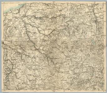
Composite: 73. Heiligenbeil. (Germany)
1 : 100000 Reichsamt fur Landesaufnahme
Karte von Ermeland oder zweites Blat von Westpreussen
1 : 225000 Prusko Západní Endersch, Johann Friedrich Amon, Anton F.A. Schraembl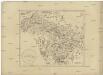
Karte von Ermeland oder zweites Blat von Westpreussen
1 : 225000 Prusko Západní Endersch, Johann Friedrich Amon, Anton F.A. Schraembl
Karte von Ermeland oder zweites Blat von Westpreussen
1 : 225000 Prusko Západní Endersch, Johann Friedrich Amon, Anton F.A. Schraembl
Tabvla geographica episcopatvm Warmiensem in Prvssia exhibens, Heilsberg, solita habitatio episcopalis, longitudinem 38. graduum, et 16. minutorum ab insula Ferro numerat
1 : 220000 Lidzbark Warmiński-oblast (Polsko) Endersch, Johann Friedrich Grabowski, Adam Stanisław Ioannes Fridericus Endersch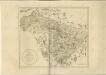

73. Heiligenbeil. (Germany)
1 : 100000 Reichsamt fur Landesaufnahme
Karte vom Kreise Rössel, Reg. Bez. Königsberg
Karte vom Kreise Rössel, Reg. Bez. Königsberg, gefestigt und herausgegeben von G. Schamberg's lithographischer Anstalt. Königsberg
Composite: 102. Wormditt. (Germany)
1 : 100000 Reichsamt fur Landesaufnahme
Composite: 133. Mohrungen. (Germany)
1 : 100000 Reichsamt fur Landesaufnahme
102. Wormditt. (Germany)
1 : 100000 Reichsamt fur Landesaufnahme
134. Allenstein. (Germany)
1 : 100000 Reichsamt fur Landesaufnahme
103. Heilsberg. (Germany)
1 : 100000 Reichsamt fur Landesaufnahme
Composite: 134. Allenstein. (Germany)
1 : 100000 Reichsamt fur Landesaufnahme
Composite: 103. Heilsberg. (Germany)
1 : 100000 Reichsamt fur Landesaufnahme
Composite: 104. Rossel. (Germany)
1 : 100000 Reichsamt fur Landesaufnahme
104. Rossel. (Germany)
1 : 100000 Reichsamt fur Landesaufnahme
Composite: 135. Sensburg. (Germany)
1 : 100000 Reichsamt fur Landesaufnahme
Sect. 14. Heiligenbeil, uit: Geologische Karte der Provinz Preussen
1 : 100000 Annotatie: Incompleet; Voor aanwezige bladen zie bladoverzicht; Met inzetkaarten; Annotatie geografische gegevens: Coördinaten gebaseerd op nulmeridiaan van Ferro (Hierro) Berlin : Neumann
Sect. 15. Friedland, uit: Geologische Karte der Provinz Preussen
1 : 100000 Annotatie: Incompleet; Voor aanwezige bladen zie bladoverzicht; Met inzetkaarten; Annotatie geografische gegevens: Coördinaten gebaseerd op nulmeridiaan van Ferro (Hierro) Berlin : Neumann
Plan zur Schlacht bei Heilsberg am 10. Juni 1807
1 : 25000 Annotatie: Uit Bd. 4 van: Der Krieg von 1806 und 1807 / O. von Lettow-Vorbeck. - Berlin : Mittler, 1896; Fotogr. reprod. van origineel uit: Der Krieg von 1806 und 1807 ... / E. von Höpfner. - Berlin : Schropp, 1850 Berlin : Mittler
Meßtischblatt 2292 : Ribben, 1938
1 : 250000 Ribben. - Hrsg. 1914, einz. Nachtr. 1929, redakt. Änd. 193. - 1:25000. - [Berlin]: Reichsamt für Landesaufnahme, 1938. - 1 Kt.
Meßtischblatt 2291 : Mensguth, 1938
1 : 250000 Mensguth. - Hrsg. 1915, bericht. 1929, redakt. Änd. 1938. - 1:25000. - [Berlin]: Reichsamt für Landesaufnahme, 1938. - 1 Kt.
Meßtischblatt 2289 : Gr. Kleeberg, 1929
1 : 250000 Gr. Kleeberg. - Hrsg. 1914, bericht. 1929. - 1:25000. - [Berlin]: Reichsamt für Landesaufnahme, 1929. - 1 Kt.
Meßtischblatt Allenstein
1 : 250000 Allenstein. - Hrsg. 1914, bericht. 1929, redakt. Änd. 1938. - 1:25000. - [Berlin]: Reichsamt für Landesaufnahme, 1938. - 1 Kt.
Meßtischblatt 2286 : Thierberg, 1929
1 : 250000 Thierberg. - Hrsg. 1913, bericht. 1929. - 1:25000. - [Berlin]: Reichsamt für Landesaufnahme, 1929. - 1 Kt.
Meßtischblatt 2285 : Osterode, 1929
1 : 250000 Osterode. - Hrsg. 1913, bericht. 1929. - 1:25000. - [Berlin]: Reichsamt für Landesaufnahme, 1929. - 1 Kt.
Meßtischblatt 2290 : Gr. Purden, 1938
1 : 250000 Gr. Purden. - Hrsg. 1914, bericht. 1929, redakt. Änd. 1938. - 1:25000. - [Berlin]: Reichsamt für Landesaufnahme, 1938. - 1 Kt.
Meßtischblatt 2287 : Dietrichswalde, 1938
1 : 250000 Dietrichswalde. - Hrsg. 1913, bericht. 1929, redakt. Änd. 1938. - 1:25000. - [Berlin]: Reichsamt für Landesaufnahme, 1938. - 1 Kt.