Maps of gmina Biskupiec

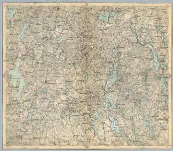
Composite: 135. Sensburg. (Germany)
1 : 100000 Reichsamt fur Landesaufnahme
135. Sensburg. (Germany)
1 : 100000 Reichsamt fur Landesaufnahme
Meßtischblatt 2192 : Bredinken, 1938
1 : 250000 Bredinken. - Hrsg. 1918, einz. Nachtr. 1928, redakt. Änd. 193. - 1:25000. - [Berlin]: Reichsamt für Landesaufnahme, 1938. - 1 Kt.
Meßtischblatt 2191 : Bischofsburg, 1938
1 : 250000 Bischofsburg. - Hrsg. 1918, einz. Nachtr. 1928, redakt. Änd. 193. - 1:25000. - [Berlin]: Reichsamt für Landesaufnahme, 1938. - 1 Kt.
Meßtischblatt 2193 : Sensburg, 1938
1 : 250000 Sensburg. - Hrsg. 1918, einz. Nachtr. 1928, redakt. Änd. 193. - 1:25000. - [Berlin]: Reichsamt für Landesaufnahme, 1938. - 1 Kt.
Meßtischblatt 2092 : Kabienen, 1935
1 : 250000 Kabienen. - Hrsg. 1918, einz. Nachtr. 1928, gedr. [19]35. - 1:25000. - [Berlin]: Reichsamt für Landesaufnahme, 1935. - 1 Kt.
Meßtischblatt 2091 : Rothfließ, 1932
1 : 250000 Rothfließ. - Hrsg. 1918, einz. Nachtr. 1928, gedr. [19]32. - 1:25000. - [Berlin]: Reichsamt für Landesaufnahme, 1932. - 1 Kt.
Meßtischblatt 2093 : Giesenau, 1938
1 : 250000 Giesenau. - Hrsg. 1918, einz. Nachtr. 1928, redakt. Änd. 193. - 1:25000. - [Berlin]: Reichsamt für Landesaufnahme, 1938. - 1 Kt.
Meßtischblatt 2293 : Aweyden, 1938
1 : 250000 Aweyden. - Hrsg. 1915, einz. Nachtr. 1929, redakt. Änd. 193. - 1:25000. - [Berlin]: Reichsamt für Landesaufnahme, 1938. - 1 Kt.
Meßtischblatt 2292 : Ribben, 1938
1 : 250000 Ribben. - Hrsg. 1914, einz. Nachtr. 1929, redakt. Änd. 193. - 1:25000. - [Berlin]: Reichsamt für Landesaufnahme, 1938. - 1 Kt.
Meßtischblatt 2291 : Mensguth, 1938
1 : 250000 Mensguth. - Hrsg. 1915, bericht. 1929, redakt. Änd. 1938. - 1:25000. - [Berlin]: Reichsamt für Landesaufnahme, 1938. - 1 Kt.
133. Mohrungen. (Germany)
1 : 100000 Reichsamt fur Landesaufnahme
Karte vom Kreise Rössel, Reg. Bez. Königsberg
Karte vom Kreise Rössel, Reg. Bez. Königsberg, gefestigt und herausgegeben von G. Schamberg's lithographischer Anstalt. Königsberg
28 Lötzen, uit: Special-Karte von Mittel-Europa / nach amtlichen Quellen bearbeitet von W. Liebenow
1 : 300000 titelvariant: W. Liebenow's Mittel-Europa; Annotatie: Titel boven de bladen: W. Liebenow's Mittel-Europa Johannes Wilhelm Liebenow 1822-1897 Frankfurt a. M. : Ludwig Ravenstein
Regni Borussiae Episcopatus Warmiensis Palatinatus Mariaeburgensis et Culmensis cum Territorio Dantiscano et Ichnographia Urbis Regiomontis].
Mollova mapová sbírka
Composite: 73. Heiligenbeil. (Germany)
1 : 100000 Reichsamt fur Landesaufnahme

Karte von Ermeland oder zweites Blat von Westpreussen
1 : 225000 Prusko Západní Endersch, Johann Friedrich Amon, Anton F.A. Schraembl
Karte von Ermeland oder zweites Blat von Westpreussen
1 : 225000 Prusko Západní Endersch, Johann Friedrich Amon, Anton F.A. Schraembl
Karte von Ermeland oder zweites Blat von Westpreussen
1 : 225000 Prusko Západní Endersch, Johann Friedrich Amon, Anton F.A. Schraembl
168. Ortelsburg. (Germany)
1 : 100000 Reichsamt fur Landesaufnahme
Composite: 168. Ortelsburg. (Germany)
1 : 100000 Reichsamt fur Landesaufnahme
Composite: 104. Rossel. (Germany)
1 : 100000 Reichsamt fur Landesaufnahme
Meßtischblatt 1991 : Bischofstein, 1938
1 : 250000 Bischofstein. - Hrsg. 1915, einzelne Nachtr. 1928, redakt. Änd. - 1:25000. - [Berlin]: Reichsamt für Landesaufnahme, 1938. - 1 Kt.
Meßtischblatt 1992 : Rößel, 1938
1 : 250000 Rößel. - Hrsg. 1915, einzelne Nachtr. 1928, redakt. Änd. - 1:25000. - [Berlin]: Reichsamt für Landesaufnahme, 1938. - 1 Kt.
Meßtischblatt 1993 : Heiligelinde, 1941
1 : 250000 Heiligelinde. - Aufn. 1913., hrsg. 1918, letzte Nachtr. 1928, Au. - 1:25000. - [Berlin]: Reichsamt für Landesaufnahme, 1941. - 1 Kt.
104. Rossel. (Germany)
1 : 100000 Reichsamt fur Landesaufnahme
Meßtischblatt 2094 : Weißenburg, 1938
1 : 250000 Weißenburg. - Hrsg. 1927, einz. Nachtr. 1928, redakt. Änd. 193. - 1:25000. - [Berlin]: Reichsamt für Landesaufnahme, 1938. - 1 Kt.
Meßtischblatt 2194 : Rechenberg, 1938
1 : 250000 Rechenberg. - Hrsg. 1927, einz. Nachtr. 1928, redakt. Änd. 193. - 1:25000. - [Berlin]: Reichsamt für Landesaufnahme, 1938. - 1 Kt.