Maps of Süderlügum

Composite: 22. Tondern. (Germany)
1 : 100000 Reichsamt fur Landesaufnahme
Messtischblatt 95 : Tondern, 1895 Tondern
1 : 250000 Tondern. - Aufn. 1878, hrsg. 1880, einz. Nachtr. 1895. - 1:25000. - [Berlin]: Reichsamt für Landesaufnahme, 1895. - 1 Kt.
Messtischblatt 126 : Süder-Lügum, 1888 Süder-Lügum
1 : 250000 Süder-Lügum. - Aufn. 1878, hrsg. 1880, einz. Nachtr. 1888. - 1:25000. - [Berlin]: Reichsamt für Landesaufnahme, 1888. - 1 Kt.
22. Tondern. (Germany)
1 : 100000 Reichsamt fur Landesaufnahme
Messtischblatt 96 : Bülderup, 1880 Bülderup
1 : 250000 Bülderup. - Aufn. 1878. - 1:25000. - [Berlin]: Reichsamt für Landesaufnahme, 1880. - 1 Kt.
Messtischblatt 127 : Ladelund, 1880 Ladelund
1 : 250000 Ladelund. - Aufn. 1878. - 1:25000. - [Berlin]: Reichsamt für Landesaufnahme, 1880. - 1 Kt.
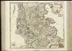
PRÆFECTVRA | TONDERN | sine Lundtofft Herde | Anno 1648
Christian Rothgießer | Husum. sculps. [Amsterdam : Joan Blaeu]
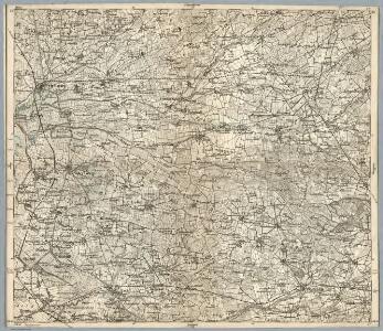
8. Westerland 9. Tondern, uit: Topographische Uebersichtskarte des Deutschen Reiches / herausgegeben v. d. Kartogr. Abt. d. Königl. Preuß. Landesaufnahme
1 : 200000 titelvariant: Topogr. Übersichtskarte des Deutschen Reiches; Annotatie: Titel boven bladen ook: Topogr. Übersichtskarte des Deutschen Reiches; Annotatie geografische gegevens: Op elk blad twee maatstokken: 10 Kilometer = 5,5 cm; 1 geogr. Meile = 3,6 cm; Legenda onder op elk blad Königlich Preußische Landesaufnahme. Kartographische Abtheilung [S.l : Königlich Preußische Landesaufnahme, Kartographische Abtheilung]
PRÆFECTVRÆ | TONDERANÆ | ORA MARITIMA
Matthias & Nicolaus Peters | Goldtschmide gebr. Hus. | sculps. [Amsterdam : Joan Blaeu]
Praefectvra Apenrade et Luntoft herde
1 : 95000 Mollova mapová sbírka Mejer, Johannes Rothgiesser, Christian Lorenzen Blaeu, Joan I.
Messtischblatt 94 : Hoyer, 1895 Hoyer
1 : 250000 Hoyer. - Aufn. 1878, hrsg. 1880, einz. Nachtr. 1895. - 1:25000. - [Berlin]: Reichsamt für Landesaufnahme, 1895. - 1 Kt
Messtischblatt 125 : Neukirchen, 1886 Neukirchen (in Schleswig)
1 : 250000 Neukirchen (in Schleswig). - Aufn. 1878, hrsg. 1880, einz. Nachtr. 1886. - 1:25000. - [Berlin]: Reichsamt für Landesaufnahme, 1886. - 1 Kt.
Tondern 10, uit: Special-Karte von Mittel-Europa / nach amtlichen Quellen bearbeitet von W. Liebenow
1 : 300000 titelvariant: W. Liebenow's Mittel-Europa; Annotatie: Titel boven de bladen: W. Liebenow's Mittel-Europa Johannes Wilhelm Liebenow 1822-1897 Frankfurt a. M. : Ludwig Ravenstein
Szleswig
Deutschland Dänemark Regierungsbezirk Schleswig Grenze Wierzbicki, B.
Ducatus Slesvicensis Pars Septentrionalis. [Karte], in: Novus atlas absolutissimus, Bd. 1, S. 158.
1 Karte aus Atlas Janssonius Offizin
[left] FRISIA BOREALIS | IN DVCATV SLESWICENSI | sive FRISIA CIMBRICA | Anno 1651. [right] FRISIA BOREALIS | IN DVCATV SLESWICENSI | Anno 1240. | Frisia Cimbrica Antiqua.
Matthias & Nicolao Peters | Goldtschmide gbr. Husum. sculps. [Amsterdam : Joan Blaeu]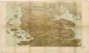
Das Herzongthum Schleswig

Schleswig.
1 : 427000 Gotthard, A.
Herzogthum Schleswig
Grosser Hand-Atlas über alle Theile der Erde in 170 Karten Meyer, J. Verlag des Bibliographischen Instituts
DVCATVS | SLESWICI | PARS MERIDIONALIS.
Matthias undt Nicolaus Peters Goldts. gebr. | Hus. sculps. [Amsterdam : Joan Blaeu]
Ducatus Slesvicensis
1 : 312700 Šlesvicko Homann, Johann Baptist a Ioh. Baptista Homan[n]o
DUCATUS SLESVICENSIS juxta novißimam et accuratißimam Designationem
1 : 325000 Šlesvicko Seutter, Matthäus sumtibus Matth. Seutteri

Fiona vulgo Funen [Karte], in: Theatrum orbis terrarum, sive, Atlas novus, Bd. 1, S. 50.
1 Karte aus Atlas Blaeu, Joan Blaeu, Willem Janszoon
Holsatiae descrip
1 Karte : Kupferdruck ; 32 x 23 cm Jorden; Ortelius s.n.
Ducatus Slesvicensis in omnes suas praefecturas circulos et provincias distinté divisus
1 : 310000 per F. de Wit 't Amsterdam : by F. de Wit, op den Dam, inde Witte Pascaert
Fionia vulgo Funen [Karte], in: Le théâtre du monde, ou, Nouvel atlas contenant les chartes et descriptions de tous les païs de la terre, Bd. 1, S. 52.
1 Karte aus Atlas Blaeu, Willem Janszoon und Blaeu, Joan Blaeu, Willem Janszoon
Ducatus Slevicensis Australis Pars. [Karte], in: Novus atlas absolutissimus, Bd. 1, S. 161.
1 Karte aus Atlas Janssonius Offizin